Published September 20, 2013 02:42PM
Pacific Crest Trail: WA Section 4
SHEEP LAKE to WHITE PASS: Get high into the snowy contours of Goat Rocks Wilderness on this 22.2-mile leg. Bring an ice axe and lightweight crampons for the Packwood Glacier.


Trail Facts
- Distance: 35.8
Waypoints
PCT1463
Location: 46.453067779541, -121.431396484375
Head NE on Nannie Ridge Trail to Sheep Lake to reach the PCT; very nice camping, good swimming and views towards Mt. Adams.
PCT1464
Location: 46.4722328186035, -121.431137084961
Ridge offers beautiful views of the Goat Rocks and Klickton Divide. Continue N through one of the most scenic sections of the entire PCT.
PCT1465
Location: 46.4829483032227, -121.434364318848
Head NW from Cispus Pass; look for herds of mountain goats that often hang out below the pass to the SE in the Klickitat headwaters
PCT1466
Location: 46.4898834228516, -121.434753417969
Pass a spectacular camp near small clump of trees; enjoy the alpen glow on the mountain face that rises above campsite
PCT1467
Location: 46.4903831481934, -121.435066223145
Cispus River crossing.
PCT1468
Location: 46.4898986816406, -121.443168640137
Trail passes below a 20-ft. waterfall
PCT1469
Location: 46.4873657226562, -121.444129943848
Pass decent camps perched on this steep slope over the Cispus River
PCT1470
Location: 46.485782623291, -121.451164245605
Pass another camp
ADVERTISEMENT
PCT1471
Location: 46.4875679016113, -121.459632873535
Stay R @ Bypass Trail jct.
PCT1472
Location: 46.4933319091797, -121.464050292969
Pass a camp
PCT1473
Location: 46.4950828552246, -121.46411895752
Pass spring
PCT1474
Location: 46.4986152648926, -121.464065551758
Stay straight @ Snowgrass Trail jct.; continue N
PCT1475
Location: 46.5115661621094, -121.464965820312
Yelverton Shelter site: No shelter exists here anymore. U-shaped stone walls make a good windbreak in this very exposed area. There are many tent sites above and below this spot. Enjoy spectacular views of peaks, grassy slopes and communities of dwarf hemlock, alpine fir, and less-than-foot-high junipers. Look for marmots in the rocks
PCT1476
Location: 46.5143508911133, -121.460716247559
Follow trail up Old Snowy Mtn.; snowslides and rockslides often destroy the trail. If conditions are sketchy, consider the PCT alternate route (it’s also the access trail for the Old Snowy Summit, a worthy goal). The alternate route travels above the regular trail. From the saddle, veer L on crumbly, narrow trail.
PCT1477
ADVERTISEMENT
Location: 46.5181579589844, -121.455528259277
Begin ridge walk
PCT1478
Location: 46.5382995605469, -121.455017089844
Stay straight on ridge @ jct.
PCT1479
Location: 46.540283203125, -121.449150085449
Cross creek with great alpine campsites
PCT1480
Location: 46.5391159057617, -121.421600341797
Turn L and head N @ trail jct.
PCT1481
Location: 46.5438499450684, -121.418014526367
Pass Lutz Lake on L
PCT1482
Location: 46.5539169311523, -121.420120239258
Head NW from Tieton Pass
PCT1483
Location: 46.5754013061523, -121.398986816406
Veer L @ jct. with Hidden Spring Trail
PCT1484
Location: 46.5847320556641, -121.401168823242
Turn L @ Shoe Lake Trail jct.
PCT1485
Location: 46.59228515625, -121.400115966797
Stay high and veer L; continue N toward Hogback Mtn.
PCT1486
Location: 46.6063003540039, -121.402946472168
Goat Rocks Wilderness boundary
PCT1487
Location: 46.617733001709, -121.387252807617
Stay R @ jct. with Chair Lift Trail
PCT1488
Location: 46.6255836486816, -121.372932434082
Turn L @ jct. with trail that leads to Twin Peaks
PCT1489
Location: 46.6273002624512, -121.37491607666
Pass Ginnette Lake, a tree rimmed lake
PCT1490
Location: 46.6334648132324, -121.378067016602
Cross creek
PCT1491
Location: 46.6430015563965, -121.378852844238
Pass trailhead
PCT1492
ADVERTISEMENT
Location: 46.6435012817383, -121.379364013672
US 12; cross to continue; or turn L, follow road to Kracker Barrel Grocery; not great resupply, staff is welcoming; find fried foods like burritos; indoor seating; laundry. Hotel to E of store has fairly decent prices; offers bunk beds, kitchen.
PCT1493
Location: 46.639331817627, -121.390296936035
White Pass @ US 12.
More PCT: Next Section | Previous Section
Split Rocks
Location: 46.5106391906738, -121.46558380127
©Jack Haskel
Packwood Glacier
Location: 46.5134925842285, -121.462478637695
One of two permanent glacier crossings in Goat Rocks, this shaded patch can be very icy. If so, consider going around, it’s not far if you head downhill to get around. The runout isn’t bad from a fall, but serious injury could result. The second patch later on is much more dangerous even though it’s only 10 feet across. ©Jack Haskel
Glacial striations
Location: 46.511402130127, -121.465713500977
©Jack Haskel
Cairn
Location: 46.5119590759277, -121.464981079102
ADVERTISEMENT
Looking northwest past one of the area’s many large carins at Hawkeye Point and Goat Lake. ©Jack Haskel
Klickton Divide
Location: 46.4721298217773, -121.430877685547
©Jack Haskel
Cispus Pass
Location: 46.482982635498, -121.434532165527
©Jack Haskel
Campsite view
Location: 46.4902839660644, -121.43473815918
Vew up the river to the mountain above the camp. ©Jack Haskel
Valley and Peaks
Location: 46.4783897399902, -121.432861328125
A long-range view over the Goat Rocks. ©Jack Haskel
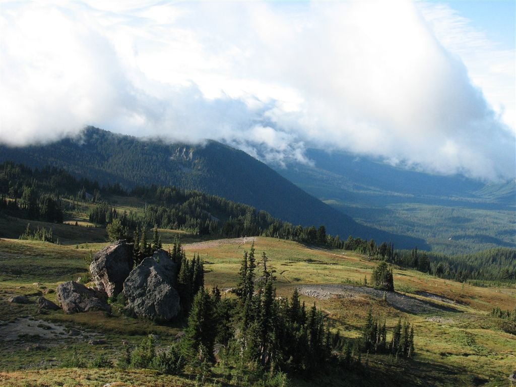
Clouds and valley
Location: 46.5275573730469, -121.452789306641
©Jack Haskel