Published September 20, 2013 02:41PM
Pacific Crest Trail: WA Section 13
HARTS PASS to CANADA: The last 34-mile leg of the PCT might be one of the grandest, and possibly the least-traveled. In the remote Pasatayen Wilderness, hikers are the minority compared to the prized wildlife populations (grizzlies, gray wolves, lynx).


Trail Facts
- Distance: 54.2
Waypoints
PCT1737
Location: 48.7211685180664, -120.670234680176
Trail heads NE from Hart’s Pass and campground with bathroom
PCT1738
Location: 48.7241172790527, -120.664733886719
Creek crossing
PCT1739
Location: 48.7323341369629, -120.677146911621
Stay L @ trail jct.
PCT1740
Location: 48.776683807373, -120.721298217773
Creek crossing
PCT1741
Location: 48.7772331237793, -120.721969604492
Pass camp nestled at the foot of Tamarack Peak
PCT1742
Location: 48.8106155395508, -120.732849121094
Cross Shaw Creek
PCT1743
Location: 48.8210487365723, -120.734382629395
Pass camp; continue N
PCT1744
Location: 48.8344497680664, -120.735847473145
Creek crossing
PCT1745
Location: 48.8397331237793, -120.737686157227
Stay straight @ Holman Pass trail jct.
PCT1746
Location: 48.8525657653809, -120.747779846191
Creek crossing
PCT1747
Location: 48.8580322265625, -120.743919372559
Pass great camp with spring
PCT1748
Location: 48.8629989624023, -120.742469787598
Pass a spring
PCT1749
Location: 48.8828010559082, -120.762199401855
Bear L @ jct.; ascend to Woody Pass
PCT1750
Location: 48.8851509094238, -120.767402648926
Woody Pass; head N
PCT1751
Location: 48.9267845153809, -120.765502929688
Spur to Hopkins Lake on R
PCT1752
Location: 48.9258842468262, -120.767082214355
ADVERTISEMENT
Hopkins Lake, a round lake nestled in a cirque, is a great place to camp your last night on the trail. Head NE to Hopkins Pass
PCT1753
Location: 48.9292678833008, -120.762702941895
Head N from Hopkins Pass; Blizzard Peak rises to the NE
PCT1754
Location: 48.9560661315918, -120.780632019043
Head N to Castle Pass
PCT1755
Location: 48.9779510498047, -120.789817810059
Cross creek; look to the SE for Mt. Winthrop’s pointed peak
PCT1756
Location: 48.9972839355469, -120.805130004883
Cross creek
PCT1757
Location: 49.0019683837891, -120.801750183105
Creek crossing
PCT1758
Location: 49.0002670288086, -120.802085876465
Monument 78 marks the US-Canada border
PCT1759
Location: 49.0022010803223, -120.803031921387
Pass an excellent camp
PCT1760
Location: 49.002498626709, -120.803619384766
Creek crossing
PCT1761
Location: 49.0328483581543, -120.773834228516
Cross creek
PCT1762
Location: 49.036449432373, -120.763763427734
“PCT Camp”
PCT1763
Location: 49.0377006530762, -120.763717651367
Stay straight @ jct. with Frosty Mtn. Trail
PCT1764
Location: 49.0471496582031, -120.764533996582
Keep straight @ jct. with Windy Joe Rd.
PCT1765
Location: 49.0574340820312, -120.775497436523
Trail curves to the W
PCT1766
Location: 49.060115814209, -120.789199829102
Pass beaver dam ponds
PCT1767
Location: 49.0638847351074, -120.798164367676
Head E towards HWY 3 and Manning Park Lodge
PCT1768
Location: 49.0637512207031, -120.799369812012
ADVERTISEMENT
Trailhead. To reach HWY 3, turn R onto Gibson Pass Rd.
PCT1769
Location: 49.0637321472168, -120.785453796387
HWY 3 in Manning Provincial Park.
More PCT: Previous Section
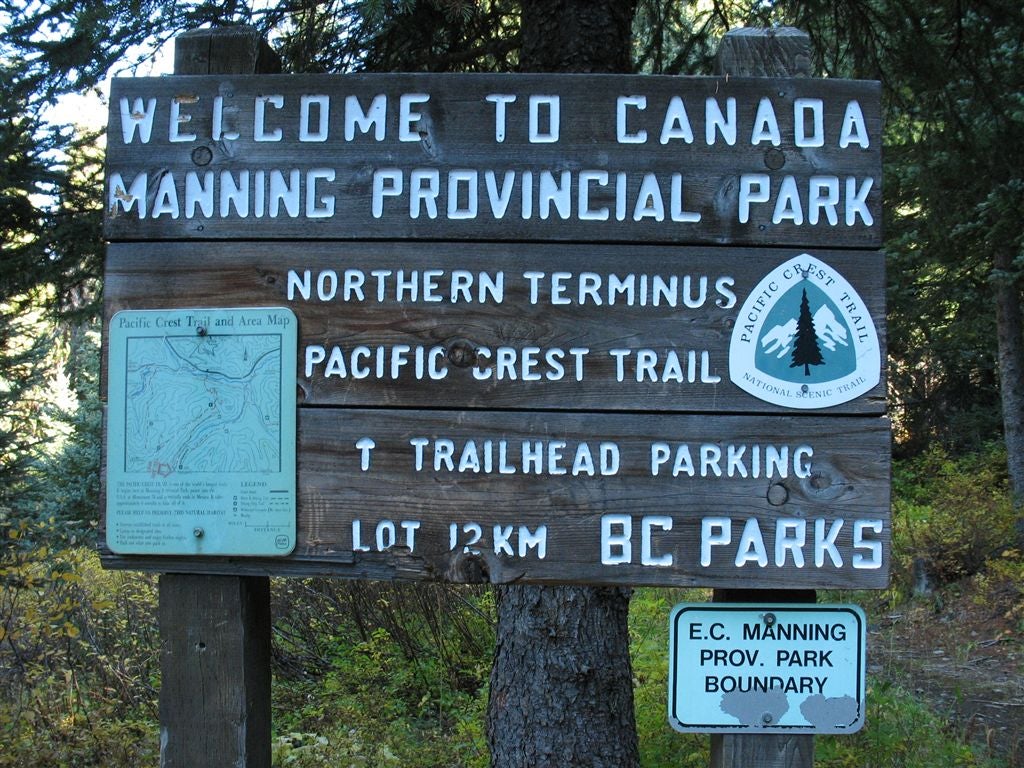
Manning Provincial Park
Location: 48.9992828369141, -120.801376342773
©Jack Haskel
Pop the bubbly
Location: 49.0005950927734, -120.801704406738
A thru-hiker prepares to celebrate after reaching the border. ©Jack Haskel
Jack at the border
Location: 48.9992828369141, -120.800720214844
BACKPACKER’s map contributor 2,600 miles later, at the Canadian border. ©Jack Haskel
Basking in the glow
Location: 48.9996109008789, -120.802360534668
A hiker sits at the nothern terminus. ©Jack Haskel
Treaty of 1840 Marker
Location: 49.0003776550293, -120.801483154297
The offical US-Canada border. ©Jack Haskel
Wildlife
Location: 48.9142570495606, -120.745910644531
A few locals cross a meadow. ©Jack Haskel
Open slopes
Location: 48.957820892334, -120.76399230957
©Jack Haskel
Ridgeline
Location: 48.8841323852539, -120.746376037598
©Jack Haskel