Published September 20, 2013 03:17PM
Olympic National Park: Seven Lakes Loop
Explore old growth rain forest, ascend 5,474-foot Bogachiel Peak, and reap stunning views of Mt. Olympus from High Divide's ridgeline on this 17.5-mile loop around a breathtaking subalpine lake basin.
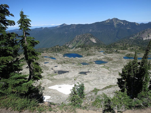
Hikers who scale this airy, 5,000-foot ridgeline will trek above lake-filled basins and score unrivaled views of 7,965-foot Mt. Olympus—the tallest peak in the Olympics. Get there about midway through a 17.5-mile lasso loop starting on the Sol Duc River Trail. Hike southeast .8 mile to Sol Duc Falls, where the river splits into three parallel channels and plummets into a pinched, moss-dusted gorge.
From here, the route climbs up the valley another 4.6 miles, then bends south, gaining nearly 1,400 feet in 2.1 miles to a meadowy campsite near Heart Lake. The next day, ascend the grassy basin for less than half a mile, past thinning patches of subalpine firs and avalanche lilies, to the crest of the ridge.
ADVERTISEMENT
Now comes the big show: Trace the spine west for aerial views of teal-colored Sol Duc, Long, and Lunch Lakes to the north and Mt. Olympus towering above the Hoh River valley to the south. At mile 9.7, take a quarter-mile (round-trip, nontechnical) detour to 5,474-foot Bogachiel Peak for final views of Olympus. Drop 1,900 feet to Deer Lake, then finish off the loop with a 3.3-mile descent along Canyon Creek.
INFO For information on weather and current trail, camp, and road conditions, go to nps.gov/olym/planyourvisit/current-conditions.htm.
PERMIT A wilderness permit is required for all overnight camping in the backcountry. For more details, go to nps.gov/olym/planyourvisit/wilderness-trip-planner.htm
CONTACT Olympic National Park, (360) 565-3130; nps.gov/olym/
ADVERTISEMENT
Trail Facts
- Distance: 28.1
Waypoints
SLK001
Location: 47.954844, -123.834779
Begin hiking east from Sol Duc trailhead
SLK002
Location: 47.952139, -123.820939
Straight @ Deer Lake Trail junction
SLK003
Location: 47.951469, -123.819466
Enjoy the mist of Sol Duc Falls in the middle of this old growth rain forest
SLK004
Location: 47.938195, -123.779615
Trail passes through valley along Sol Duc Creek; elk are commonly spotted here
SLK005
Location: 47.932306, -123.750554
Continue straight at the 3-way junction; the trail gently ascends east. Ahead, pass Sevenmile Shelter on right
SLK006
Location: 47.913188, -123.730845
Pass another shelter, then enter Sol Duc Park, a rugged, treeless expanse to the left
SLK007
Location: 47.909828, -123.73429
ADVERTISEMENT
Heart Lake, great campsite with mountainous views
SLK008
Location: 47.907846, -123.737528
Turn right at T-junction. Option: Add a day and visit Cat Basin; turn left onto Cat Basin spur trail
SLK009
Location: 47.907069, -123.750564
Hike along High Divide, a long ridgeline over-looking Seven Lakes Basin to north and Hoh River Valley to south
SLK010
Location: 47.905457, -123.777745
Summit Bogachiel Peak at 5,474 feet; great views to the north of Sol Duc, Long, and Lunch Lakes, and of 7,828-foot Mt. Olympus to the south. Continue along ridgeline
SLK011
Location: 47.925794, -123.8226
Deer Lake, superb campsite; turn right and follow Deer Lake Trail north to Sol Duc Trail
SLK012
Location: 47.952071, -123.82066
Turn left and retrace route back to the trailhead