Published September 2, 2008 05:46PM
Hike Olympic National Park
Explore two ecosystems in this hinterland of moss-draped forests, ancient trees, and snowcapped peaks.
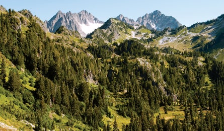
'Dosewallips Mountains (Don Geyer)'
What distinguishes backpacking in Olympic National Park from any other park in the Lower 48? The ability to go from one of the planet’s lushest temperate rainforests to alpine wildflower meadows beneath glaciated peaks. The stunning scenery has not gone unnoticed: Olympic’s best-known hikes can offer all the solitude of a Seattle coffee shop. Beat the crowds by following in the footsteps of the 1890 Press Expedition, led by the first non-native Americans to cross the Low Divide, a high pass that divides drainages between the Pacific and Puget Sound.
Entrance Strategy
Getting there The closest major airport is Sea-Tac (Seattle), which is a bit more than two hours from both Lake Quinault and Port Angeles. From US 101 at the west end of Lake Quinault, drive the North Shore Road east, turn left on the North Fork Road, and follow it to its end at the North Fork Quinault trailhead.
Season July for wildflowers, August and September for clear-sky views, and September for bugling elk.
Best frontcountry campground Sol Duc, an hour’s drive from the gateway town of Port Angeles, has 80 first-come sites tucked among old-growth forest (try to get one on the river). It’s a short walk from your tent site to three hot-spring-fed pools at the Sol Duc Hot Springs Resort ($11; 360-327-3583, visitsolduc.com).
Pre-trip breakfast Port Angeles locals go to Chestnut Cottage for omelets loaded with spinach, mushrooms, cashews, and cream cheese. Top it off with an oversized cinnamon roll. Located just east of downtown at 929 E. Front Street (360-452-8344).
Gear shop Brown’s Outdoor, 112 W. Front St., in Port Angeles (360-457-4150, brownsoutdoor.com) has everything from rain shells to hammocks, perfect for hanging under the mossy canopy.
Permits Get your permit, bear canister, and trail beta at the Wilderness Information Center in the visitor center outside Port Angeles (360-565-3100, nps.gov/olym/wic/index.html). Reservations aren’t needed for the hikes described here, but for other trips, apply up to 30 days predeparture at nps.gov/olym/planyourvisit/upload/wildernesspermitreservationform.pdf.
ADVERTISEMENT
The Trip
Hike a legendary explorer’s route. Retrace the Press Expedition’s adventure on this five-day loop on the North Fork Quinault.
It took James Christie and the Press Expedition five and a half months to traverse the Olympic Peninsula from north to south. Get a memorable taste of their adventure on this 45-mile epic through virgin forest and high alpine peaks along the North Fork Quinault River in the southwest corner of the park. In the rainforest, enormous cedar, hemlock, fir, and spruce tower over an understory of moss and vine; above, the trees give way to jagged mountains smothered in snow and ice.
ADVERTISEMENT
From the end of the North Shore Road, take the undulating North Fork Quinault Trail through gargantuan trees; you’ll hike beneath their canopy for 16 miles before reaching the Low Divide at 3,600 feet. The trail gains elevation steadily–3,100 feet–while crossing numerous gorges slashed into the mountainsides by crashing tributaries. Look for Roosevelt elk, river otters, and three-slash tree marks, the signature blaze of the Press Party. The first of several campsites is located just 2.6 miles out, but press on to Twelvemile Camp (funny, we GPS’d it at 11.6 miles) to set yourself up for the next day’s stellar side hike.
It’s 4.3 miles from Twelvemile Camp to Low Divide Camp on day two. Get there early enough to do the six-mile roundtrip from Low Divide to Martins Park, where you’ll enter a boulder-strewn alpine garden filled with yellow monkey flower and subalpine buttercup, plus Waterford-clear streams babbling beneath the Mt. Christie Glacier. Listen for whistling marmots and keep your eyes peeled for black bears gone fat on late summer’s juicy huckleberry harvest. The path terminates at Martins Lakes, on a ridge high above one of the deepest, longest valleys in the Olympics, the Elwha. Take it in, then backtrack to Low Divide for your second night.
Over days three and four, you’ll traverse the Queets-Quinault Divide, which towers 4,000 feet above impossibly deep valleys. From Low Divide, pick up the Skyline Trail, which trends generally southwest for about 20 miles. The views from the ridge are the best in the Olympics. Eight miles from Low Divide, pitch your tent at secluded Lake Beauty, where chunks of ice bob in the water into late summer. At 5.7 miles beyond Lake Beauty, scramble to the summit of 5,399-foot Kimta Peak. Then continue another 5.2 miles to Three Prune Camp, near an overlook of Three Prune Basin.
The loop’s final nine miles follow the last leg of the Skyline and the Three Lakes, Big Creek, and Irely Lake Trails, descending from subalpine conditions through one of the most magnificent stands of Alaska cedar in the Olympics. (Look for the world’s largest-known specimen. It’s located a mile east of Three Lakes, at approximately 3,000 feet elevation and about 40 feet north of the Big Creek Trail.) Plan B: dosewallips trail loop Severe storms sometimes close roads or wash out bridges, leaving trailheads inaccessible. If your dream trip gets flooded out, head up the Dosewallips and West Fork Dosewallips Trails for a combined 9.1 miles to Honeymoon Meadows. From there, it’s a 23.3-mile loop over Anderson, O’Neil, and La Crosse Passes. Backtrack down the West Fork Dosewallips Trail. The Dosewallips River Road has been closed by a major washout for several years, but you can hike around the 100-yard gap and up the road to the walk-in Dosewallips Campground, where this trip begins.
Exit Strategy
Clean up Get a spit shine at the Clallam County Family YMCA in Port Angeles ($1.50 for shower, $8 for a full-day pass) and save your money for a swanky hotel with an in-room hot tub in Seattle. (360) 452-9244
Pig out The Crabhouse Restaurant on the Port Angeles waterfront has–you guessed it–the best crab cakes on this stretch of coast. They’re made with locally caught Dungeness. (360) 457-0424, pacrabhouse.com
Best Dayhike: Lake Angeles-Heather Park Loop This 13-miler features virgin forest, wildflowers, one of the largest lakes in the Olympics, and climbs to views of Port Angeles, the Olympic Mountains, and the North Cascades across the Strait of Juan de Fuca. Pick up the trailhead on Hurricane Ridge Road near the visitor center, outside Port Angeles.
Try something new You’ve seen two of the three major ecosystems in the Olympics. Now head for the coast on a sea-kayak trip along the Dungeness Spit. From the Dungeness National Wildlife Refuge, near Sequim, paddle seven miles to a historic lighthouse. You’ll see harbor seals, sea lions, bald eagles, and water birds. Olympic Raft and Kayak conducts guided tours and rents gear for DIY trips ($99 per person guided, $45 for an eight-hour kayak rental). (888) 452-1443 or (360) 452-1443, raftandkayak.com
ADVERTISEMENT
Stay Dry in Soggy Country
The Olympics are part rainforest. Don’t grow mold.
Be flexible If the forecast calls for days of heavy rain, head to Obstruction Peak in the park’s northeast corner. The roughly 29-mile loop on the Elk Mountain, Cameron Creek, Grand Pass, and Badger Valley Trails lies entirely in the range’s rainshadow.
Go late Dry weather sometimes lasts into the first half of October, which also falls outside the May 1 to September 30 period when hiker quotas are enforced in popular areas like Ozette Coast and the Hoh Valley.
You’re a Tourist, Now Act Like One
Learn about the 3,300-square-mile Olympic Coast National Marine Sanctuary’s unique ecosystem and wildlife at the Olympic Coast Discovery Center on the Port Angeles waterfront. Staff can also tell you the best spots to see whales, shoot coastal scenes, or enjoy secluded beaches. (360) 452-3255, olympiccoast.noaa.gov/AboutUs/ocdc.html
The Stats
Acres 922,651
Miles of trail 600+
Website nps.gov/olym Phone (360) 565-3131
2007 visitation 3 million (total), 70,215 (backcountry)