Updated December 4, 2024 12:14AM
Mountain Map: New York - Catskills
Explore a pristine wilderness of soaring peaks and quiet valleys just three hours from New York City.
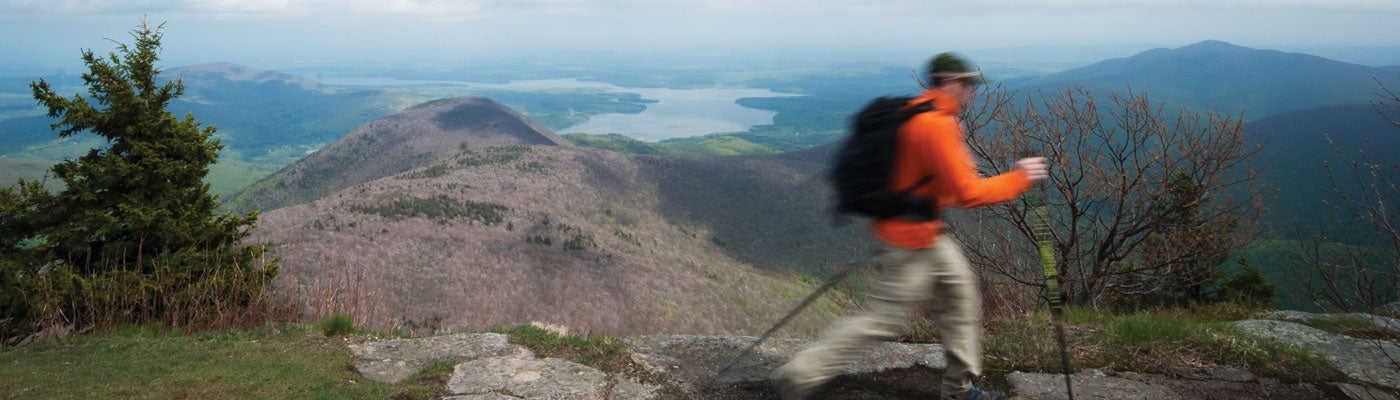
'Wittenberg's Summit View'
Devil’s Path
With an elevation profile like an EKG and nearly 18,000 feet of gain and loss, this 25-mile point-to-point will get your heart pumping. Bag six peaks above 3,500 feet, with stellar views of the area’s glacial cirques. From the Prediger trailhead, warm up by topping 3,573-foot Indian Head at mile 3, then hit three more burly summits over the next 10 miles. The trail’s eastern half offers two more summits, but fewer steep downhills. Rejuvenate with soaks in the many streams along the way. Option: Camp at Devil’s Tombstone at mile 14.1. Trip ID 8836
Balsam Mountain
Challenge yourself on a 5.7-mile out-and-back that includes one of the range’s steepest trails. From the McKinley Hollow parking area, your first mile is deceptively easy. But soon the trail steepens, reaching 35-percent grades as you climb 1,000 feet in the next 1.3 miles. Catch your breath as the slope levels out through mountain ash and red cherry. Reach Balsam’s treed-in, 3,610-foot high point at mile 2.5; continue .3 mile along the level summit to a clearing offering views of Plateau, Hunter, and West Kill Mountains. Trip ID 1240837
Burroughs Range
“The works of man dwindle,” naturalist John Burroughs wrote in the 1880s about his ascent of 4,180-foot Slide Mountain, the Catskills’ tallest peak. Follow his footsteps on this 11.7-mile out-and-back that tags three peaks. From the Slide Mountain parking area, gain 1,760 feet in 2.7 miles up Slide for views of the cliffy Shawangunks to the south. Continue east another 2.4 miles, descending ladders and passing over 3,860-foot Cornell Mountain. Turn back at mile 5.1, after snagging views to the 8,400-acre Ashokan Reservoir from 3,780-foot Wittenberg Mountain. On the way out, take the Curtis-Ormsby Trail .8 mile past Slide’s summit to descend 2.2 miles through balsam forests to the trailhead. Trip ID 31718
Panther Mountain
Sample forested slopes, rock scrambling, and stay-awhile views on this 6.7-mile out-and-back to a 3,720-foot peak. From the trailhead on NY 47, travel through rocky sections, with scrambling at mile .7, to a lookout over the Burroughs Range at mile 1.7. Hike through balsam fir and yellow birch to a steep ascent beginning at mile 2.6 (gain 1,600 feet). Reach Panther Mountain’s unmarked summit at mile 3.3 and enjoy panoramas of more peaks and the lush Hudson Valley. Trip ID 1240852
Peekamoose and Table Mountains
Get two summits to yourself in this isolated corner of the Slide Mountain Wilderness on a 9.9-mile out-and-back. From Denning Road, hike 1.1 miles along the wooded Phoenicia-East Branch Trail. Cross the Neversink River (on bridges) twice in .3 mile, then start a thigh-burning, 2.4-mile, 1,600-foot climb to Table Mountain’s 3,847-foot summit. Look for an unmarked trail leading .1 mile south to views of Slide and Peekamoose, then continue a mile on the established trail. A large boulder marks Peekamoose’s 3,843-foot peak at mile 4.9; walk 50 feet farther for an open panorama. Trip ID 5710