Updated July 11, 2025 01:10PM
Mountain Map: Adirondacks - The High Peaks
Get a field-scouted tour of the High Peaks.
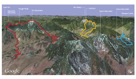
'The Adirondacks (Image from Google Earth)'
They’re not tall, but they’re tougher than snot. The steep, rocky, rooty beasts at the heart of northern New York’s 6.1-million-acre tract of deeply wild forest arguably present the toughest hiking terrain in America. Dive in head first with our primer for the best hiking in and around the ‘Dack’s 43 4,000-footers.
Great Range Loop
Views of the High Peaks are dominated by the Great Range, an imposing chain of eight 4,000-foot peaks 12 miles southeast of Lake Placid. While many hikers choose to gaze at it from easier trails, those who tackle this demanding 11.2-mile lasso will trace the range’s airy ridgeline to three of its northernmost summits. Pick up West River Trail and amble southwest along the East Branch Ausable River through hemlock and beech. The climbing ramps up on Gothics-Armstrong Trail, gaining 2,700 feet in the 2.4-mile stretch to Gothics’s 4,736-foot summit. Hike north across slabs and krummholz to 4,400-foot Armstrong Mountain. Descend ledges on the back to finish the day’s climb on 4,185-foot Upper Wolfjaw. Trip ID*840435
Giant’s Nubble
Need a quick fix? Scale the 2,760-foot knob on the flanks of Giant Mountain to see head-on views of the Great Range’s rolling, granite-topped peaks. Get there on a 3.6-mile point-to-point that ascends the Ridge Trail, past wood sorrel and raspberries, to Giant Washbowl, a cliff-rimmed pool stocked with brook trout. Crest the Nubble at mile 1.3, then return on Roaring Brook Trail. Trip ID938224
Macomb Mountain, Hough Peak, & The Dixes
Sharpen your routefinding skills on this burly 17.3-mile loop that links a set of faint, unmarked trails to the tops of five 4,000-foot peaks. Trip ID368779
Rooster Comb/Snow Mountain
Swarms of hikers buzz the slopes of popular Noonmark Mountain, leaving nearby peaks people-free. Veer north three miles to tag two of its quieter neighbors on a 6.3-mile loop. Climb 1,700 feet in 2.5 miles to 2,789-foot Rooster Comb, then hike east to tackle a short, .3-mile scramble to 2,360-foot Snow Mountain with eastern views of Giant Mountain. Trip ID307753
Mt. Marcy
There’s no better place to scope out the High Peaks than from the tallest vantage point in the state. Climb it on a 14.2-mile out-and-back only 20 minutes south of Lake Placid. Follow the Van Hoevenberg Trail south 2.1 miles to the wooded banks of Marcy Dam. Bear left around the east side of the lake for a 5.1-mile ascent that hits treeline at 5,000 feet and ends on Marcy’s roomy, 5,344-foot rock crown. Trip ID34982
*Get free GPS data and print custom maps by adding the Trip ID to backpacker.com/hikes/_______.