Published September 20, 2013 03:11PM
Mount Rainier National Park: Gobblers Knob
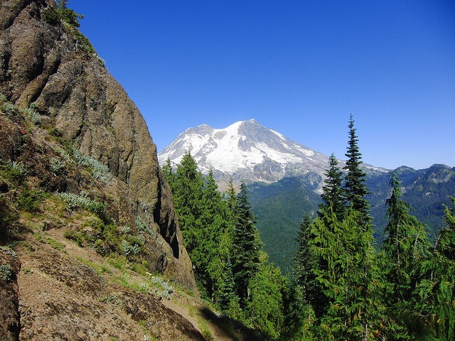
This 7.4-miler boasts unmatched views of Mount Rainier, not to mention wildflower meadows and campsites by a mountain lake.
From the small parking area, hike northeast into Glacier View Wilderness, aptly named for its west-side views of the hanging glaciers on Mount Rainier. In 100 yards, turn right onto Puyallup Trail (Trail 248) for a cruisy stretch south. Less than half a mile later, turn left and hike along the edge of Beljica Meadows, a narrow field covered with bog orchids, asters, and lupines; look south for views of Mount Beljica. Near end of the meadow, the trail skirts a shallow, 2-acre pond (likely seasonal).
One mile into the hike, turn left on Trail 248 and head north toward a steep, ankle-twister descent into Goat Lake basin (huckleberries in summer); campsites rim the long shoreline of Goat Lake. At mile 2.7, continue southeast into Mount Rainier National Park and prepare for a steep uphill ahead. After 3.3 miles, the route turns left for the final, 450-foot climb to Gobblers Knob. Relish the exquisite views of Mount Rainier from this crowd-free summit, then retrace your steps to the car.
ADVERTISEMENT
INFO For information on permits, current trail and camp conditions, and wilderness guidelines, go to nps.gov/mora/planyourvisit/wilderness-camping-and-hiking.htm.
PERMIT A wilderness permit is required for all overnight camping in the backcountry. Reservations requests accepted by fax or mail, starting on March 15th of each year ($20/reservation). Download form at nps.gov/mora/planyourvisit/wilderness-reservation-information.htm.
CONTACT Mt. Rainier National Park, (360) 569-2211; nps.gov/mora
Trail Facts
- Distance: 11.9
Waypoints
GKT001
Location: 46.7962255, -121.9475663
Head east.
GKT002
Location: 46.7966001, -121.9468528
Hike into Glacier View Wilderness, aptly named for its west-side views of the hanging glaciers on Mount Rainier. Turn right onto Puyallup Trail (labeled 248).
GKT003
Location: 46.7925383, -121.9461179
Turn left @ 3-way junction, heading east.
GKT004
Location: 46.7924728, -121.9428864
Beljica Meadows: Half-mile meadow is covered with bog orchids, asters, and lupines, plus view straight up Mount Beljica.
GKT005
Location: 46.7886598, -121.9383609
Near end of meadow is a shallow 2-acre pond (likely seasonal).
GKT006
Location: 46.7899894, -121.9355607
Go left @ junction with Christine Trail (249), staying on Trail 248.
GKT007
Location: 46.7966515, -121.9309902
ADVERTISEMENT
Steep, ankle-twister descent into Goat Lake basin (huckleberries in summer).
GKT008
Location: 46.7945068, -121.9254327
Fine campsites rim the long shoreline of Goat Lake.
GKT009
Location: 46.7930965, -121.9187593
Sign marks boundary of Mount Rainier National Park. Steep uphill ahead.
GKT010
Location: 46.7911206, -121.9130731
More lovely meadows lead to a nondescript pass. Important: Stay straight and go downhill on trail, ignoring faint footpath on left. You need to descend slightly, then go up again.
GKT011
Location: 46.791996, -121.9130249
Turn left @ T with Gobblers Knob Trail. Only 450 feet to the summit.
GKT012
Location: 46.7943077, -121.9143448
Gobblers Knob offers exquisite views of Mount Rainier. After 1 to 3 hours on this crowd-free summit, retrace steps to car.