Updated September 3, 2024 03:34PM
Six Days on the Wonderland Trail: Fryingpan Creek to Mowich Lake Hike
Explore Mount Rainier from nearly every angle on this classic, weeklong stretch of the Wonderland Trail in Mount Rainier National Park.
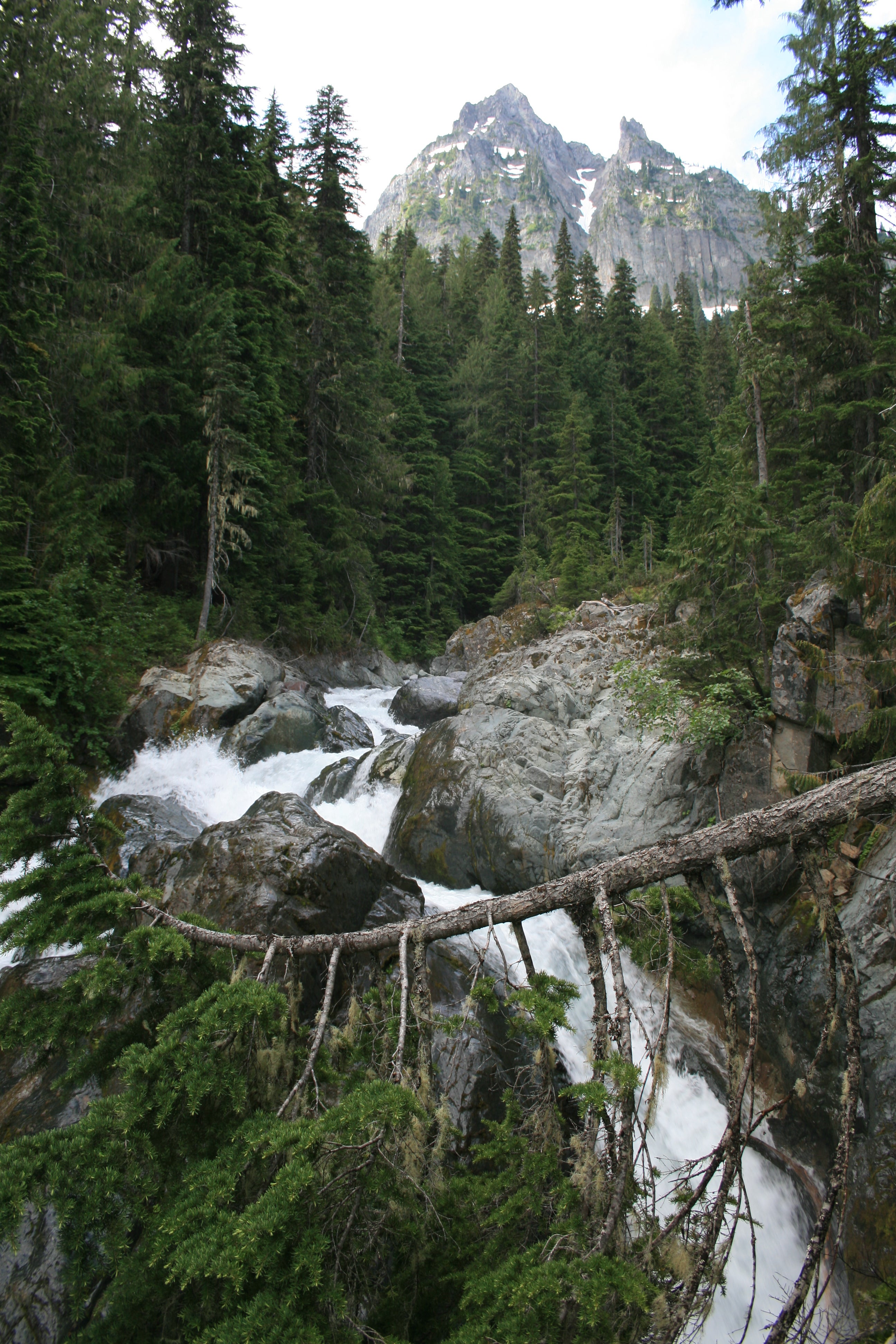
In just six days, this 57.5-mile, roller-coaster route from Fryingpan Creek to Mowich Lake racks up a total elevation gain of 19,301 feet (and a loss of 18,183 feet) as it wraps around Mount Rainier’s glacier-chiseled terrain. This section of the Wonderland Trail in Mount Rainier National Park will let you explore the namesake mountain from just about every angle. The hike has a vast diversity of terrain—flower-filled meadows, snowfields, volcanic riverbeds, multiple amazing waterfalls, and suspension bridges. There are stunning views throughout.
Trail Facts
- Distance: 57.5-mile one-way
- Elevation Gain: 19,301 feet
- Difficulty: Challenging
The Hike from Fryingpan Creek to Mowich Lake
Day One: Fryingpan Creek to Indian Bar Shelter

After leaving the Sunrise Park Road trailhead, start a sustained, nearly 3,000-foot climb that parallels the cascades of Fryingpan Creek. At the head of the valley, scale switchbacks that deliver you to Summerland, a rolling, high-country meadow filled with wildflowers.
Next, pass the Summerland Shelter, a rock and timber lean-to, and keep climbing southwest to 6,750-foot Panhandle Gap, the highpoint of the Wonderland Trail. Linger at the top with resident mountain goats for views that stretch across the southern horizon to distant glacier-capped Mount Adams and, on clear days, Mount Hood.
ADVERTISEMENT
Drop down the backside and traverse small snowfields above Ohanapecosh Park. At mile 8.3, cross Indian Bar, where the braided channels of the Ohanapecosh River vein the volcanic riverbed, then cross a bridge above Wauhaukaupauken Falls, gushing through a small slot canyon. Less than 200 feet later, drop your pack and spend the night at Indian Bar Shelter; deer and elk mingle in the adjacent meadows at dusk.
Day Two: Indian Bar Shelter to Maple Creek Camp

The next day, warm up with an 800-foot climb to a 5,930-foot high point on Cowlitz Divide. Trace the ridgeline southeast for three miles, before descending to Nickel Creek and Box Canyon. Turn south at mile 15.3 and hike roughly 1.5 miles to the mouth of Stevens Canyon. Sleep at Maple Creek Camp near mile 18.
Day Three: Maple Creek Camp to Paradise River Camp
Climb out of the valley on day three, passing Sylvia and Martha falls—and the crowd-pleasing Reflection and Louise lakes at the head of the canyon. Begin the 5.8-mile descent into Paradise Valley and Longmire a mile later. Pause at mile 24 to stare at Narada Falls, a two-tiered waterfall that plunges 168 feet, then 20 feet over cliffs (ice climbers scale the upper falls in winter). Pitch your tent a mile from here in the forested Paradise River Camp.
Day Four: Paradise River Camp to Devils Dream Camp

On day four: Pass back-to-back Madcap and Carter falls at mile 25.2 and 25.5, and continue the southwest descent to Longmire, the park’s former headquarters and the most popular place to start and finish the Wonderland Trail. Just north of the park buildings, the route swings north for a steep, 1,050-foot climb up forested Rampart Ridge (dayhiking crowds diminish in a mile). Less than two miles later, the trail rolls over the ridgetop and drops north into Kautz Creek (springtime washouts are common; link the cairns to find log crossings). Half a mile later, cross Pyramid Creek, then climb 2.2 miles to Devils Dream Camp.
ADVERTISEMENT
Day Five: Devils Dream Camp to North Puyallup Camp
Rise early on the fifth day for the one-mile stretch to Indian Henrys Hunting Ground. Spend some down-time in the sprawling, wildflower fields, backdropped by Rainier’s southwest face, before starting the 1.1-mile, 1,050-foot descent to a suspension bridge slung high above Tahoma Creek’s broad and rocky riverbank. After two more rigorous climbs and two knee-jarring descents, cross the bridge over the North Puyallup and sleep at its same-name camp (mile 45).
Day Six: North Puyallup Camp to Mowich Lake
On the last day, climb past the flowery meadows and clusters of lakes that dot Sunset Park (black bears come here in the fall for the huckleberries) before descending into the Mowich River valley. Cross the South and North Mowich Rivers and begin the final 3.2-mile, 2,330-foot climb to the bustling Mowich Lake Campground and your shuttle car.
Why You’ll Love This Hike to Mowich Lake

The 50-plus-miler from Fryingpan Creek to Mowich Lake Campground is filled with beautiful views of peaks, adventures through passes, and hikes through meadows and past towering waterfalls. Here’s what you can look forward to along this hike:
ADVERTISEMENT
Preserves, Meadows, and Wilderness Areas
- Summerland
- Indian Henry’s Hunting Ground
- Ohanapecosh Park
- Sunset Park
Lakes and Rivers
- Reflection Lake
- Louise Lake
Mountain Views

- Mount Adams
- Mount Hood
Waterfalls
- Wauhaukaupauken Falls
- Sylvia Falls
- Martha Falls
- Narada Falls
- Madcap Falls
- Carter Falls
Parking and Logistics for hike to Mowich Lake

The Trailhead
Shuttle car drop: Drive southeast on WA 410 E for 11 miles and turn right onto Mundy Loss Rd. In 1.2 miles, turn left onto WA 162 E for .3 mile, then go straight on WA 165 S. Go 25 miles to parking at Mowich Lake Campground.
To trailhead: Return to the WA 162/WA 165 junction; turn right to stay on WA 165. In 1.6 miles, turn right onto WA 410 E. In 41.4 miles, bear right onto Sunrise Park Rd./White River Rd. Go 4.3 miles to parking pull-out.
Permits
A wilderness permit is required for all overnight camping in the backcountry. Get more information on permits, current trail and camp conditions, and wilderness guidelines.
ADVERTISEMENT
Other
Food Cache: To decrease the amount of food you must haul on the first three days, leave a food cache at the Longmire Wilderness Information Center before starting the trip. nps.gov/mora/planyourvisit/caching-food-and-fuel.htm
River Crossings: Bridge washouts are common along this route. Check with a ranger before heading out on the trail to get up-to-date information on water levels and trail conditions.
The Map: Fryingpan Creek to Mowich Lake via the Wonderland Trail
Mapping and info provided by David Tate and NPS GIS data