Published September 20, 2013 03:32PM
Moab, UT: Fisher Towers
This short hike threads through a hoodoo-filled climbing mecca with outrageous scenery and countless sidetrip options.
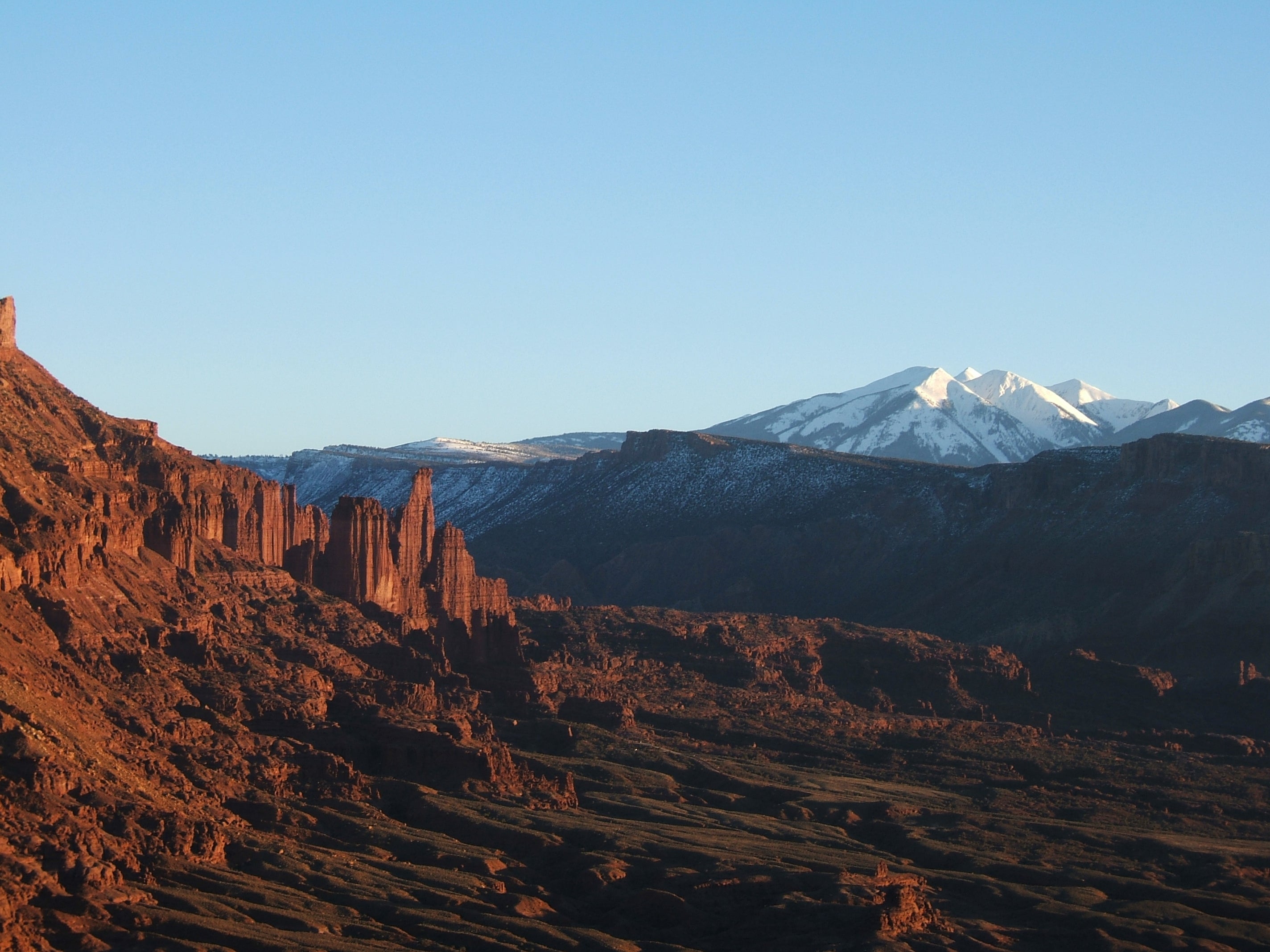

This shot was taken from a cliff we climbed across the Colorado River, about 5 crow miles away from Fisher Towers. It was just about sunset, and the rock started glowing. To the right are the LaSal mountains.

Once on the trail, the views immediately get spectacular. This photo shows the wild variety of shapes and colors in Fisher Towers.

A view from one of many sandstone domes down into a wash where the trail is winding through on its way deeper into the park. The trail moves up to the base of the main wall that most of the spires lift out of; numerous side canyons drop away from trail.

Looking up from the same wash, you get a great sense of the erosive power of wind and water in a redrock environment.

First good view of Ancient Art. The route climbs up the backside of the tower to the small ridge in the sun on the right skyline. Then it wraps up and around the back of the Seusslike main feature on top, emerging on the left of it near the last bump.

More views of Ancient Art from different points along the trail.

John surveys the walls for other possible routes.

Ancient Art from the backside

Our group returns from the endpoint of the official trail, heading toward Ancient Art. By mid-morning, the Feb. sun is just strong enough that we’ve shed the thick fleece layers we were wearing. We’ll climb in long sleeves and vests, and feel just right.

Dougald’s always smiling, more so when he gets to climb.

John attacks the 5.11 crux in the first pitch. You have to make two friction moves in a concave overhang to reach small, pebble-like holds just above the lip. From there, it’s a matter of keeping feet glued to rock—easier for me at 6’6â€.

John belays Dougald with the Titan in the background.

John leading in the middle pitches. The exposure here is starting to get intense.

John walks the gangplank on the last pitch of Ancient Art, with several hundred feet of air to either side.


John Harlin leads the route.


Me rapping off and walking the plank.

John leading up The Cobra, a climb just feet from where the climber’s path for Ancient Art branches off the main trail through Fisher Towers.

John dances his Kokopelli dance atop The Cobra.

Ancient Art glows in burnt red as the sun sets.

Sunset makes the walls glow.
ADVERTISEMENT
Trail Facts
- Distance: 4.2
Waypoints
FTR001
Location: 38.7248802185059, -109.308815002441
ADVERTISEMENT
In 2/05, a small group of us visited Fisher Towers to hike and climb. We had blue skies, temps around 65, and an empty parking lot. At the trailhead were 3 Backpacker editors (Dennis Lewon, John Harlin, and me, Jon Dorn), plus Dougald MacDonald.
FTR002
Location: 38.7231597900391, -109.30876159668
The best time to hike here is dawn or dusk, when the redrock is glowing in the soft sunlight. From this spot, you get your first view of Ancient Art, a classic rock climb up the R pillar of the main formation to your L; the top looks like a crooked hand.
FTR003
Location: 38.7221336364746, -109.306716918945
Turn R and swtichback uphill away from wash. Along this trail, you’ll have towers to your left and washes leading down to your right. You could head down almost any of the washes for an off-trail adventure, even an overnight. The only limitation is water.
FTR004
Location: 38.7203636169434, -109.30396270752
Grand views of Ancient Art on L. On the R, the Titan, a 500-foot formation and classic multiday rock climb.
FTR005
Location: 38.7206420898438, -109.303413391113
ADVERTISEMENT
To reach Ancient Art, the primary feature we came to climb, leave the main trail here, jogging L on a faint track only 20 feet to a climber’s path heading sharply uphill.
FTR008
Location: 38.7188949584961, -109.30281829834
First clear photo op of The Titan, which looms ever larger. The standard climbing route goes from the Finger of Fate (the obvious prong on the L skyline) to the summit. Climbers typically bivy overnight at the base of the Finger.
FTR009
Location: 38.7164039611816, -109.300094604492
Arches National Park just visible to SW; look for the prominent towers thru the obvious notch. You’re also getting better views of Onion Creek to the S and the vast area of wild canyons waiting to be explored to the W.
FTR010
Location: 38.7109756469727, -109.303688049316
Trail ends atop a big mushroom with expansive views of thousands of acres of crazy sandstone sculptures. Return to car or explore one of many side canyons (if you have a map, GPS, and plenty of water). Stay out of narrow slots in monsoon season.
FTR006
Location: 38.7207450866699, -109.303512573242
ADVERTISEMENT
Continue L past a Seusslike formation (The Cobra), then stick to the R side of the wash, still climbing steeply. As the path levels out, you’ll wrap around the head of the wash to the L to reach a sandstone bench and the next waypoint.
FTR007
Location: 38.7213401794434, -109.303901672363
Base of Ancient Art. The route climbs directly up the chimney, then straddles the fin above. The first crux is a few moves up (but it’s also bolted). The second is on top–having the guts to walk the gangplank to the final pillar. Return to waypoint 5.
View of Fisher Towers area
Location: 38.7269630432129, -109.309539794922
This shot was taken from a cliff we climbed across the Colorado River, about 5 crow miles away from Fisher Towers. It was just about sunset, and the rock started glowing. To the right are the LaSal mountains.
Wild shapes
Location: 38.7246437072754, -109.30876159668
Once on the trail, the views immediately get spectacular. This photo shows the wild variety of shapes and colors in Fisher Towers.
Dome view
Location: 38.724178314209, -109.308547973633
ADVERTISEMENT
A view from one of many sandstone domes down into a wash where the trail is winding through on its way deeper into the park. The trail moves up to the base of the main wall that most of the spires lift out of; numerous side canyons drop away from trail.
More wild shapes
Location: 38.7242088317871, -109.308517456055
Looking up from the same wash, you get a great sense of the erosive power of wind and water in a redrock environment.
More Ancient Art
Location: 38.7231216430664, -109.308792114258
First good view of Ancient Art. The route climbs up the backside of the tower to the small ridge in the sun on the right skyline. Then it wraps up and around the back of the Seusslike main feature on top, emerging on the left of it near the last bump.
Ancient Art 2
Location: 38.7230606079102, -109.308731079102
More views of Ancient Art from different points along the trail.
Red wall
Location: 38.7136993408203, -109.301010131836
John surveys the walls for other possible routes.
Backside
Location: 38.7212333679199, -109.30330657959
Ancient Art from the backside.
The approach
Location: 38.7190322875977, -109.302963256836
ADVERTISEMENT
Our group returns from the endpoint of the official trail, heading toward Ancient Art. By mid-morning, the Feb. sun is just strong enough that we’ve shed the thick fleece layers we were wearing. We’ll climb in long sleeves and vests, and feel just right.
Lunch
Location: 38.7214813232422, -109.304084777832
Dougald, the former editor of Rock and Ice magazine, and John, a longtime Backpacker editor and now the editor of the prestigious American Alpine Journal, grab a bite and get their racks ready for a four or five pitch climb.
Dougald
Location: 38.7214813232422, -109.303955078125
Dougald’s always smiling, more so when he gets to climb.
The crux
Location: 38.7216339111328, -109.304145812988
John attacks the 5.11 crux in the first pitch. You have to make two friction moves in a concave overhang to reach small, pebble-like holds just above the lip. From there, it’s a matter of keeping feet glued to rock—easier for me at 6’6”.
On belay
Location: 38.7216033935547, -109.304176330566
John belays Dougald with the Titan in the background.
Middle pitch
Location: 38.7215118408203, -109.304176330566
John leading in the middle pitches. The exposure here is starting to get intense.
The gangplank
Location: 38.7216339111328, -109.304176330566
ADVERTISEMENT
John walks the gangplank on the last pitch of Ancient Art, with several hundred feet of air to either side.
Balance
Location: 38.7215423583984, -109.30411529541
John makes his way up and around to the top.
Start climb
Location: 38.7215728759766, -109.30411529541
Climb 2
Location: 38.7216339111328, -109.304176330566
John Harlin leads the route.
Climb 3
Location: 38.7216033935547, -109.304237365723
On top
Location: 38.7216033935547, -109.304237365723
The rappel
Location: 38.7215728759766, -109.30411529541
Me rapping off and walking the plank.
Thin bridge
Location: 38.7216033935547, -109.304084777832
Me walking the thin bridge in size 13 shoes.
The Cobra
Location: 38.7207069396973, -109.30345916748
John leading up The Cobra, a climb just feet from where the climber’s path for Ancient Art branches off the main trail through Fisher Towers.
Dance, dance
Location: 38.7206726074219, -109.303398132324
John dances his Kokopelli dance atop The Cobra.
Ancient Art
Location: 38.7203636169434, -109.304145812988
Ancient Art glows in burnt red as the sun sets.
Sunset glow
Location: 38.7204093933106, -109.304298400879
Sunset makes the walls glow.