Published September 20, 2013 01:03PM
Los Angeles, CA: Ontario and Bighorn Peaks via Icehouse Canyon
Explore the ruins of historic taverns and watch clouds roll over two 8,000-foot San Gabriel peaks on this 14-mile out-and-back in the Cucumonga Wilderness.
The 7-mile route over Bighorn and Ontario peaks begins in the shade of Icehouse Canyon, where hikers pass through the stone ruins of a 1920s wilderness lodge. The Icehouse Canyon Trail steadily climbs 3,200 feet in the first 5.5 miles of this trip, traveling from a lush creekside environment to coniferous forests to exposed, rocky ridgelines. After only 2 miles, you’ll drop the crowds at Icehouse Saddle and enjoy 360-degree views of nearly every peak in Cucumonga Wilderness.
More views await as you pass the crumbling foundation of another abandoned resort, Kelly Camp, and break through tree cover once again. Big skies offer up a massive panorama of the backside of Ontario, Cucamonga Peak, Bighorn, Timber Mountain, Telegraph Peak, Thunder Peak, Mount Harwood, and Mount Baldy. From the Bighorn Peak Trail, climb up a steep grade with loose talus to Bighorn then take the ridgeline trail 1.5 miles through manzanitas to Ontario. Both summits have a sweeping vista of the evergreen-blanketed San Gabriel Mountains; the tallest peak, Mount Baldy, stands out prominently to the west.
-Mapped by Casey Schreiner

©Casey Schreiner


Trail Facts
- Distance: 22.4
Waypoints
OBP001
ADVERTISEMENT
Location: 34.2503052, -117.6371765
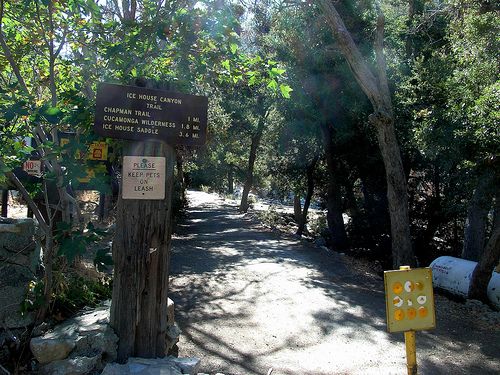
From the southeast corner of the parking lot, pass through the old gate on a semi-paved road. This is the site of Chapman’s Ice House Canyon Resort. Hike east on the Icehouse Canyon Trail for a mile, passing the resort’s stone ruins. The trail sticks to the north side of the creek, making its way through several historic cabins.
OBP002
Location: 34.2489357, -117.6218109
Bear right @ the Y-junction, heading east on Icehouse Canyon Trail.
OBP003
Location: 34.2484016, -117.6154938
Cross a small tributary of the Icehouse Canyon Creek and continue east into Icehouse Canyon. The trail leaves the riparian landscape and traverses through looser boulders and talus.
OBP004
Location: 34.246933, -117.613121
ADVERTISEMENT
Hike east over rocky terrain, making a steady, moderate ascent. The Icehouse Canyon Trail crosses into the Cucamonga Wilderness Area. The boundary is marked by two sizable boulders and a large wooden sign posted with rules, regulations, and safety tips. Hikers and backpackers in this area may be asked to show Wilderness Permits to rangers.
OBP005
Location: 34.2459488, -117.6078873
Pass a steel sign, marked with the number “2.” The trail leaves the canyon floor and begins a major ascent along the canyon’s north wall.
OBP006
Location: 34.2432442, -117.604599
Walk by Columbine Spring, a free-flowing spring and small pool just south of the trail that is the last reliable source of water on the route. Begin climbing a series of long switchbacks on the north side of Icehouse Canyon.
OBP007
Location: 34.2419205, -117.5998611
Keep right @ Y-junction.
OBP008
Location: 34.2392807, -117.5944901
Reach Icehouse Saddle (7,555 feet) at the end of Icehouse Canyon Trail. This is an exposed and often-crowded rest stop.
OBP009
Location: 34.2391014, -117.5943909
ADVERTISEMENT
Veer to the far right @ the 4-way junction, merging onto the Ontario Peak Trail. The trail heads west along the south slope of Icehouse Canyon and cuts through alpine forests and manzanita. It is often very icy during winter. Use crampons and ice axes if the weather requires them.
OBP010
Location: 34.2338982, -117.6044846
Enter Kelly Camp, the site of a former wilderness resort. Several foundations and staircases are still visible. Keep left @ the Y-junction in the camp, and head south as the trail climbs the north slope between Ontario and Bighorn peaks.
OBP011
Location: 34.2323723, -117.605896
Hop over a downed tree and follow the established trail as it climbs toward the southwest. Ignore the use-trail that heads east from the tree toward Bighorn Peak.
OBP012
Location: 34.2314377, -117.6080551
Keep left @ the Y-junction, turning onto Bighorn Peak Trail. Here, you have a phenomenal view of Bighorn Peak and Cucamonga Peak to the east as well as Timber, Telegraph, and Thunder peaks to the north. Continue on the Bighorn Peak Trail as it heads east, staying just north of the ridge.
OBP013
Location: 34.2320747, -117.6005249
ADVERTISEMENT
The Bighorn Peak Trail becomes very faint and disappears beneath patches of manzanita. Hike southeast 100 feet toward the edge of the ridge. From there, the trail becomes visible again as it climbs northeast through the brush on Bighorn Peak’s southwest face.
OBP014
Location: 34.2336845, -117.5981674
Reach the summit plateau of Bighorn Peak. Hike east about 150 feet to the summit, marked by a pile of white rocks.
OBP015
Location: 34.2336998, -117.5977097
Rest at the summit of Bighorn Peak (8,441 feet). Take in the nearly 360-degree views from the bare summit then return west on the Bighorn Peak Trail toward Ontario Peak.
OBP016
Location: 34.2314034, -117.6080246
Stay left @ the Y-junction, taking the Ontario Peak Trail. This trail heads northwest through manzanita and large swaths of dead pines and then winds around a prominent bump on the ridge.
OBP017
Location: 34.2314262, -117.6126938
Head west through another large section of dead trees.
OBP018
Location: 34.228405, -117.6194382
ADVERTISEMENT
Alternate Descent: Turn left off-trail into Falling Rock Canyon for a class 2 bouldering descent back into Icehouse Canyon. Stay on the ridge between Cherry and Falling Rock Canyons as it descends about a mile to the northwest. From here, ascend Sugarloaf Peak (6,924 feet) for commanding views of Mount Baldy Village and the Icehouse Canyon parking area. The ascent adds only about 1,400 feet to the trip. Otherwise, continue a half mile down the western side of Falling Rock Canyon through loose rock and scree. The only major obstacle is a 20-foot waterfall near Icehouse Canyon, which is passable through use-trails east of the falls. While this is not classified as a difficult route by bouldering standards, it is much more difficult than hiking along the trail.
OBP019
Location: 34.2276878, -117.6241074
Reach the summit of Ontario Peak (8,693 feet), a small rocky outcropping with spectacular views of the Baldy Bowl, Mount Baldy Village, and the rest of the San Gabriels. When finished with the view, take the Ontario Peak Trail to Icehouse Saddle and retrace steps back to the trailhead.
Trailhead
Location: 34.250248, -117.63694
©Casey Schreiner
Trail cuts into Icehouse Canyon
Location: 34.2501335, -117.634964
©Casey Schreiner
Historic cabin
Location: 34.2494545, -117.6315155
©Casey Schreiner
Ruined cabin foundation
Location: 34.2475891, -117.6151276
©Casey Schreiner
Rockier trail in upper Icehouse
Location: 34.246685, -117.6126404
©Casey Schreiner
First portion of saddle ascent
Location: 34.2457237, -117.6071014
©Casey Schreiner
Columbine Spring
Location: 34.2434082, -117.6048355
©Casey Schreiner
Hikers rest at Icehouse Saddle.
Location: 34.239563, -117.5946045
©Casey Schreiner
The Ontario Peak Trail
Location: 34.2386634, -117.5939655
©Casey Schreiner
Kelly Camp
Location: 34.2338562, -117.6042709
©Casey Schreiner
Downed log
Location: 34.2323837, -117.6057434
©Casey Schreiner
Final ascent to the ridge
ADVERTISEMENT
Location: 34.2318764, -117.6071014
©Casey Schreiner
The trail to Bighorn Peak
Location: 34.2312546, -117.6059647
©Casey Schreiner
Faint trail
Location: 34.2322159, -117.600029
©Casey Schreiner
View of Ontario from Bighorn
Location: 34.233345, -117.5990753
©Casey Schreiner
Approaching Bighorn’s summit
Location: 34.2337418, -117.5979385
©Casey Schreiner
Dead trees on Ontario’s north slope
Location: 34.2324409, -117.6100388
©Casey Schreiner
Eastern approach to Ontario
Location: 34.229332, -117.617218
©Casey Schreiner
The summit of Ontario Peak
Location: 34.2277489, -117.6243362
©Casey Schreiner
Baldy Bowl from Ontario
Location: 34.2279205, -117.6234894
©Casey Schreiner