Published September 20, 2013 01:19PM
Los Angeles, CA: Mount Markham
Ascend two rigorous saddles on this 6.3-mile out-and-back up to the unsung Mount Markham and panoramas of the San Gabriels and L.A. basin.
'Nancy <I'm gonna SNAP!'
At 5,742 feet, Mount Markham is half the size of San Gabriel’s famed bad boys: Mount Baldy, Pine Mountain, and Dawson Peak. However, this 6.3-mile out-and-back, an hour from downtown, is anything but tame. You’ll conquer two saddles, scramble over boulders, and grab views of 20 neighboring peaks.
From Mount Wilson Road, take the unnamed trail toward San Gabriel Peak, Mount Disappointment, and Mount Lowe. Climb steadily for 1.4 miles before merging with Road 12W24. Pass Mount Disappointment on the right as the L.A. Basin sprawls across the landscape. Bear right at the wooden pole intersection and descend toward the first saddle. Mount Wilson emerges to the east; Mounts Markham and Lowe to the south.
Shortly after crossing the road and taking the Mount Lowe Summit Trail, striking views stretch to the west: Los Angeles’ highest point, Mount Lukens, and the low-lying Santa Monicas. At the second saddle, head northeast toward Mount Markham’s summit up steep switchbacks and manageable boulder scrambling. Walk east on the thin trail to the summit where views of Eaton Canyon and Los Angeles await.
-Mapped by Casey Schreiner

© Casey Schreiner

© Casey Schreiner

© Casey Schreiner

© Casey Schreiner

© Casey Schreiner

© Casey Schreiner

© Casey Schreiner

© Casey Schreiner

© Casey Schreiner

© Casey Schreiner


ADVERTISEMENT
Trail Facts
- Distance: 10.1
- Miles from city center: 28
Waypoints
MTM001
Location: 34.254581, -118.102043
ADVERTISEMENT
Park at locked gate and proceed 52 feet south. Be sure to display your Adventure Pass, which allows you to access National Forests.
MTM002
Location: 34.254352, -118.102121
Trailhead: Look for a small wooden stake against some loose gray rocks. The trail may look indistinct from the parking area, but is very easy to follow. Proceed up switchbacks towards the shaded area.
MTM003
Location: 34.255137, -118.102963
Look through a clearing in the brush to the east for magnificent views of the interior of the Angeles National Forest.
MTM004
Location: 34.25441, -118.104106
At 1893 feet, look south above the low brush. The forested, conical peak topped with radio towers is Mount Disappointment, the site of some old Nike missile equipment.
MTM005
Location: 34.248554, -118.103691
At mile 1.07, the trail parallels Road 12W24. There is a small use-trail leaving the trail for the pavement. Ignore and continue on the trail.
MTM006
Location: 34.248038, -118.103907
At 1.16 miles, bear left @ the Y-junction and join Road 12W24.
MTM007
Location: 34.245159, -118.10289
ADVERTISEMENT
Stay left @ the next Y-junction. The ridge to the south has very nice views of the canyon and peaks ahead.
Option: Right at Y and follow ridge to summit of Mount Disappointment. Adds 0.5 miles roundtrip.
MTM008
Location: 34.244988, -118.102394
At 1.42 miles, pass the foundations and remains of an old Nike Missile Base, hidden behind a small mountain peak.
MTM009
Location: 34.244881, -118.102112
At 1.45 miles, veer left @ Y-junction and continue toward San Gabriel Peak. Look for a dirt trail leaving the paved road.
MTM010
Location: 34.24472, -118.101608
At 1.47 miles, turn right @ Y-junction and descend toward Mount Markham. Option: Stay straight @ Y-junction and ascend the short, steep switchbacks to San Gabriel Peak. A small bench at the top offers near 360-degree views of the San Gabriel front range. This side trip will add less than a mile to the hike.
MTM011
Location: 34.242255, -118.101032
ADVERTISEMENT
Through a clearing on the south side of the trail, look directly south: the peak to the right is Mount Lowe (another side-trip). The peak to the left is Mount Markham, which this trail ascends from the saddle between the peaks.
MTM012
Location: 34.240177, -118.099503
Leave the trail and walk about 100 feet southeast to a clearing in the chaparral. Look west toward the long ridge of Mount Wilson, which is northwest of the Wilson’s actual summit. You can also see the summit of Occidental Peak next to Mt. Wilson.
MTM013
Location: 34.239242, -118.099388
At 2.15 miles, cross the road at the 4-way junction. Traveling southwest, merge onto the Mount Lowe Summit Trail. Look for the rusted metal sign marked “To Mt. Lowe Summit.” The trail parallels the fire road, but makes a slow gain in elevation while the road remains nearly flat.
MTM014
Location: 34.236034, -118.103065
ADVERTISEMENT
Look west through Bear Canyon. The large peak with the towers to the south (left of where you stand) is Mount Lukens, the highest point within L.A. city limits. On a clear day, you may be able to make out the Santa Monica Mountains beyond these peaks.
MTM015
Location: 34.233399, -118.10505
At 2.72 miles, make a sharp left @ the Y-junction. Merge onto the use-trail and head northeast. The faint use-trail runs along a thin ridge toward Mount Markham. Though not marked on maps, it is easy to follow.
Option: Continue south about 200 yards and take a R @ the Y-junction onto the Mount Lowe Trail. Continue on the northwest slope of Mount Lowe Trail as it makes a ridge line ascent to the peak. From there, the trail splits two. One way goes west along the north side of the mountain to the summit, while the other heads south before circling west and up to the summit. Equestrian hookup and picnic benches are at the top of Lowe. This option adds about 0.8 miles round trip.
MTM016
Location: 34.235683, -118.101746
ADVERTISEMENT
At 3.01 miles, the ridge line trail has a series of very steep switchbacks (roughly a 30 percent grade). The route quickly turns into Class 2 scrambling over loose rocks and Spanish bayonets.
MTM017
Location: 34.236053, -118.101097
After 256 feet of scrambling and climbing, the trail returns to level ground as it makes a very slow ascent on Mount Markham’s summit plateau.
MTM018
Location: 34.236076, -118.100281
Continue east on the ridge line trail to the summit of Mount Markham. At 3.11 miles, a small cement cylinder deceptively appears to be a USGS summit marker. It does not mark the summit! Keep going east for 0.1 mile to Mount Markham’s actual summit at 5,742 feet.
MTM019
Location: 34.236744, -118.099197
ADVERTISEMENT
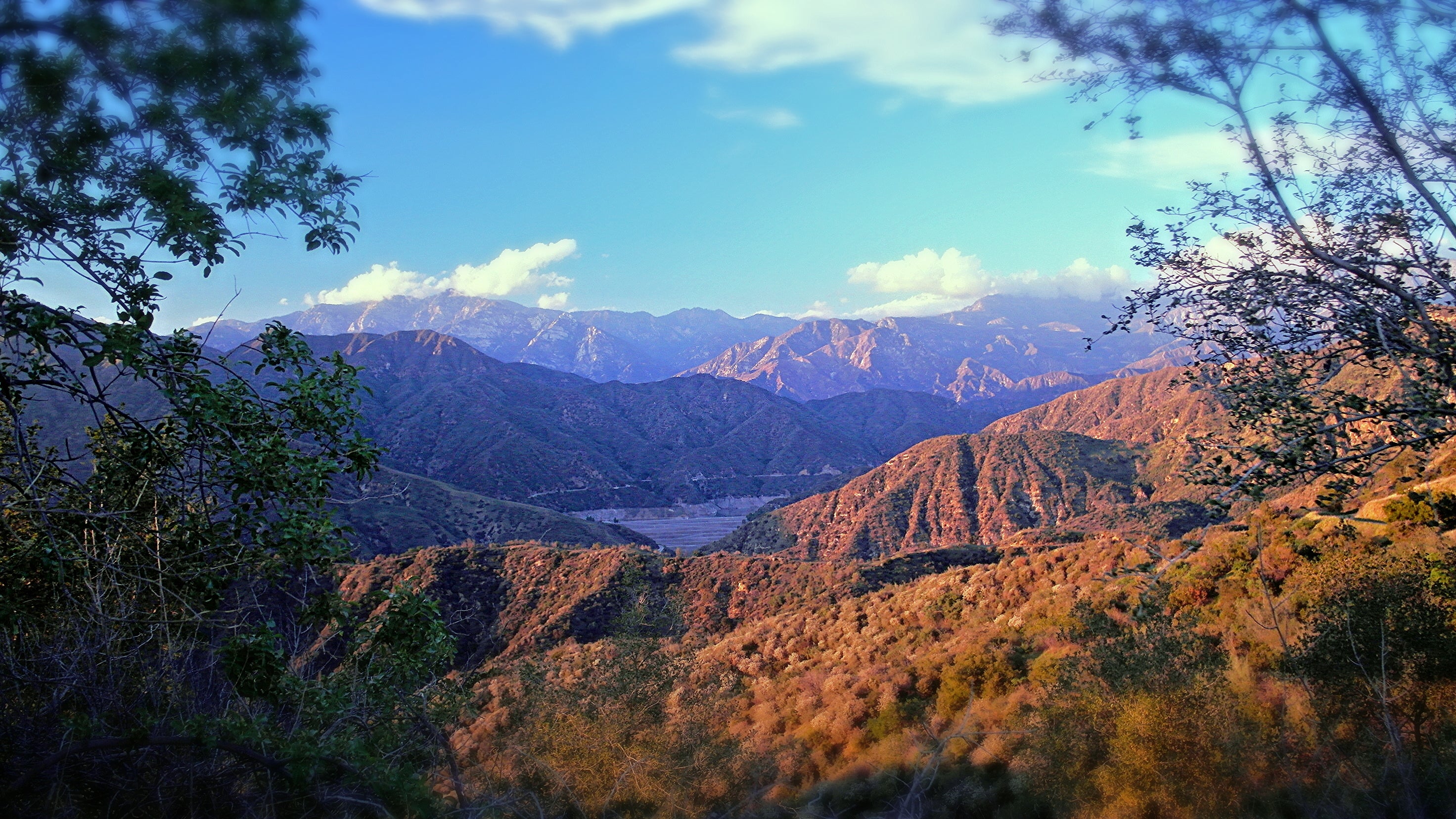
At 3.2 miles, reach the summit of Mount Markham at 5,742 feet. There is no USGS summit marker. Views are expansive on clear days. To the southwest, you can see from Santa Monica Bay and downtown across the L.A. basin. Mountains in the Cleveland National Forest may be visible to the southeast. The ridge line trail continues past the summit toward another trail, which is very overgrown. When you’ve have your fill of the views, retrace your steps back to the trailhead.
Angeles National Forest
Location: 34.255146, -118.102883
Mt. Disappointment
Location: 34.254419, -118.104009
San Gabriel Peak
Location: 34.251873, -118.105301
View west toward the prominent summit of San Gabriel Peak. © Casey Schreiner
Road 12W24
Location: 34.248011, -118.103784
© Casey Schreiner
Pines
Location: 34.24499, -118.102376
© Casey Schreiner
Road to Mt. Disappointment
Location: 34.245162, -118.102856
© Casey Schreiner
Continue on the path toward San Gabriel Peak
Location: 34.244835, -118.10199
© Casey Schreiner
View of Mt. Markham
Location: 34.24226, -118.100962
© Casey Schreiner
View of Mt. Wilson
Location: 34.240182, -118.099463
© Casey Schreiner
Sign to Mt. Lowe
Location: 34.239109, -118.099335
© Casey Schreiner
View of Mt. Lukens
Location: 34.236051, -118.102974
© Casey Schreiner
Use-trail
Location: 34.233399, -118.104942
© Casey Schreiner
Scrambling
Location: 34.235752, -118.101624
© Casey Schreiner
Not a USGS Market
Location: 34.236091, -118.100184
Don’t be fooled. The true summit of Mount Markham is another .1 miles away. © Casey Schreiner
ADVERTISEMENT
Expansive views of L.A. Basin
Location: 34.236745, -118.099154
© Casey Schreiner