Published September 20, 2013 01:05PM
Los Angeles, CA: Kenyon Devore Trail Loop to Mount Wilson
Climb over the picturesque north face of Mount Wilson, the site of a historic observatory, on this 11-mile loop in L.A.'s San Gabriel Mountains.
Starting at the west side of Mount Wilson’s 5, 710-foot summit, this challenging loop drops nearly 3,000 feet in the first 6 miles and includes steep drop-offs, precarious footing, and ridgeline trails.
Head down the Kevore Camp Trail. The forested summits of Mount Markham, San Gabriel, and Mount Lowe appear to the left after only a short distance. The trail follows Mount Wilson’s north-facing slope, and then switchbacks up to Strayns Canyon. Enter Strayns Canyon’s gulch and follow the low-lying ridge to the left of the canyon. Occidental Peak is directly west.
After crossing Strayns Canyon Creek, pass through a dense pine forest before reaching open shrubland. Turn right onto the Gabrielino Trail. You’ll slowly descend another ridge and arrive at the San Gabriel River’s West Fork. The next few miles offer no less than four boulder-hopping, river-crossing opportunities. The twisting trail begins to climb toward 4, 115-foot Newcomb Pass and back to the Mount Wilson summit.
-Mapped by Casey Schreiner


Trail Facts
- Distance: 16.9
Waypoints
MWT001
ADVERTISEMENT
Location: 34.223999, -118.0622406
Hike on Mount Wilson-Red Box Road toward the automatic gate outside the Visitor Center. Keep right @ Y-junction outside the gate. Continue following the road.
MWT002
Location: 34.2276573, -118.067955
Look for a small wooden sign at the intersection between Mount Wilson-Red Box Road, Audio Road, and Video Road. Turn right onto Kenyon DeVore Trail toward the Gabrielino Trail and West Fork Campground. On some maps, this trail is called the Rattlesnake Trail. Optional: Cross the street and look west for a great view of neighboring peaks, including Mount Lowe, Mount Markham, and San Gabriel Peak.
MWT003
Location: 34.228096, -118.0674438
Continue straight @ 4-way junction with Mount Wilson Parking Lot Trail. The trail continues along the mountain’s gradual north-facing slope on a well-marked, well-shaded route. Continue down 4 large switchbacks as the trail heads toward Strayns Canyon.
MWT004
Location: 34.2321053, -118.0666199
ADVERTISEMENT
Cross a seasonal stream running through Strayns Canyon. Pass the locked brick hut to the south and stay straight as the trail meanders along the east side of the canyon. After a little more than a mile, the trail crosses a rocky section of the canyon and then continues northwest.
MWT005
Location: 34.2383423, -118.0701218
Enter the gulch of Strayns Canyon before climbing a long ridge that’s west of the canyon. Follow the trail as it heads northeast along a low ridge above the canyon for slightly less than a half mile.
MWT006
Location: 34.2420387, -118.0686493
Cross Strayns Canyon Creek. Use caution. There is a loosely-anchored rope stretched across the stream to provide support. Over the next mile, the trail gradually leaves the shade of the pine forest and slices through scrubland.
MWT007
Location: 34.2475395, -118.0597229
Bear right @ Y-junction onto Gabrielino Trail. Continue east on the Gabrielino Trail for a little less than a mile. The trail makes a slow, gradual descent down a ridge, then reaches the southern part the San Gabriel River’s West Fork.
MWT008
Location: 34.2452583, -118.0501099
ADVERTISEMENT
Continue straight as the trail drops down to the canyon floor into the shade again. Pass large water tanks. Be aware of poison oak, which is prevalent in this area.
MWT009
Location: 34.245842, -118.0498886
Cross Rush Creek and enter West Fork Camp. After entering the camp, pass a small concrete foundation: the site of the first USFS cabin in California, built in 1900. The cabin has since been moved to the Chilao Visitor Center. The campground itself has several well-maintained sites, picnic tables, fire pits, and portable toilets. During the spring and early summer, it is nearly surrounded by Rush Creek, the West Fork, and Shortcut Canyon Creek.
MWT010
Location: 34.246273, -118.0494995
ADVERTISEMENT
Continue east and cross the dirt Rincon-Red Box Road, which heads toward the West Fork. Depending on the season, the river may be a trickle or a raging torrent of whitewater. Cross carefully to the east, looking for a small, green metal sign on the other bank. A run-down “Pack it Out” sign that marks the continuation of the trail. Look for a broad footpath that continues east.
MWT011
Location: 34.2460327, -118.0468597
Boulder hop across the West Fork to reach the south bank. Continue southeast along the West Fork on the slightly overgrown trail for less than a half mile.
MWT012
Location: 34.2439499, -118.0424881
Boulder hop across the West Fork again–this time heading to the river’s eastern shore. The trail stays north of the river for a half mile, but heads east through dense riparian forest.
MWT013
Location: 34.2432709, -118.0366287
Cross to the West Fork and continue south toward Devore Trail Camp. Optional: Stay on the north side of the West Fork and head northeast. An old angler’s trail continues through beautiful riverside forest for a mile. When the trail ends, continue for another 4 miles of bushwhacking and boulder hopping along the river until it ends at Cogswell Reservoir.
MWT014
Location: 34.2433586, -118.0360565
ADVERTISEMENT
Reach Devore Trail Camp, a primitive campsite with several riverside picnic tables. The campsite is shady and lightly used. This is a good place to camp for the night or take a short break. The rest of this hike is relentlessly uphill. Look south of the campground for the Gabrielino Trail. Merge onto this trail and continue for about a mile as it climbs ridges and switchbacks.
MWT015
Location: 34.2346382, -118.028717
Cross Rincon-Red Box Fire Road @ 4-way junction and continue south on the Gabrielino Trail.
MWT016
Location: 34.2325439, -118.0273743
Stay to the far right @ 5-way junction at Newcomb Pass (4,115 ft.) and walk toward a small memorial plaque. Merge onto the Rim Trail, which heads toward Mount Wilson. For the next mile, the trail stays relatively level, shaded, and in certain spots, eroded and thin. Follow the Rim Trail west as it parallels a long ridge of Mount Wilson. Use caution when walking past the trail’s drop-offs.
MWT017
Location: 34.2318039, -118.0451279
Stop at a highly eroded section of trail, marked by steep drop-offs. Hang on to the prominent, exposed tree roots and maneuver across this small but dangerous section of trail. Continue west. The trail cuts through manzanita bushes before switchbacking to the summit plateau.
MWT018
Location: 34.2273636, -118.0558243
ADVERTISEMENT
Reach the summit plateau of Mount Wilson (5,710 ft.). Continue west as the trail travels through a large, shaded pine grove north of the observatories.
MWT019
Location: 34.2241402, -118.0599289
Bear right @ T-junction and head west on the service road. There are informational plaques that identify the San Gabriels’ major plants. Continue on the service road to reach the parking lot.
Gabrielino Trail
Location: 34.2425575, -118.0357361
The Gabrielino Trail rises out of Devore Trail Camp.
Trail Markers
Location: 34.2296181, -118.0677643
Much of this trail is over-marked, with streamers and ribbons, cairns, and arrows chalked in the ground and on rocks.
Radio Towers
Location: 34.2242775, -118.0631714
Some of the many radio and TV towers on top of Mount Wilson.
Observatories
Location: 34.227314, -118.0562973
The Mount Wilson summit plateau.
West Fork Campground
Location: 34.2462692, -118.0492249
Mountains
Location: 34.2275429, -118.0676956
Left to right: Mount Lowe, Mount Markham, and San Gabriel Peak.
Eroded Trail
Location: 34.2320061, -118.044632
One of the worst sections of eroded trail on the Rim Trail.
Strayns Canyon Creek
Location: 34.2323837, -118.0667572
ADVERTISEMENT
The creek runs dry in late August.
West Fork
Location: 34.2449493, -118.0440063
Some of the beautiful scenery along the West Fork, en route to Devore Trail Camp.
Scrub
Location: 34.2469635, -118.0617294
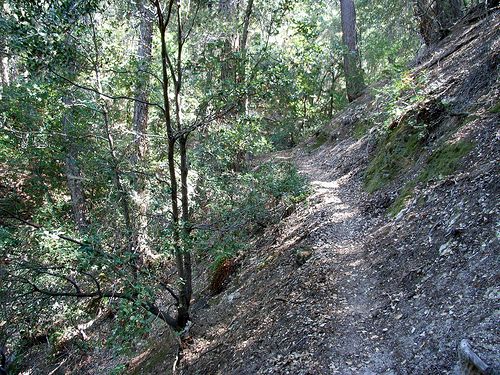
Rim Trail
Location: 34.2328186, -118.0290375
Forested trail typical on the Rim Trail.
Parallel the Gulch
Location: 34.2391701, -118.0697708
Views from Strayns Canyon.