Updated July 8, 2025 02:06PM
Los Angeles, CA: Inner Basin Pass, Joshua Tree National Park
Scramble across the trailless desert in Joshua Tree's wild northeast corner to inner Basin Pass. BY EMELIE FROJEN
'Inner Basin Pass'
I need to scramble on all fours to reach the top of the crumbly ridge. When I look up to survey my progress, I see canyons splitting the desert in every direction. The boulder-strewn wash I followed to get here melts into the desert floor, which is dotted with Joshua trees and yellow wildflowers. I feel like a pioneer in the Wild West—not a tourist midway through a 10.4-mile overnight in a national park. There are no trails in the northeast corner of Joshua Tree National Park, so this could actually be the first time someone has climbed this ridge. But it won’t be the last.
Trip stats
Distance: 10.4 miles (out and back)
Time: 2 days
Turn-by-turn
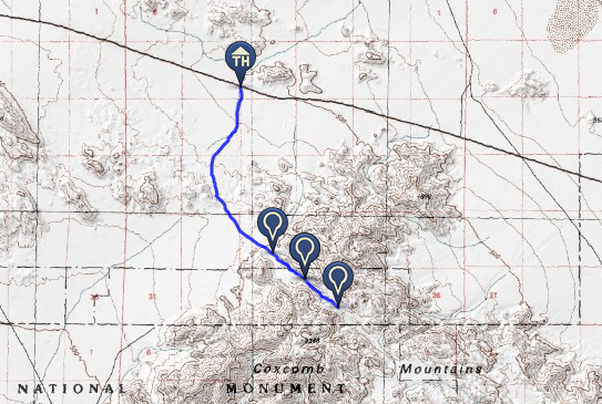
From milepost 73 on Twentynine Palms Highway (CA 62)
(1) Head 3.6 miles south toward the Coxcomb Mountains in a distinct, unnamed wash to where it merges with another (much larger) wash at the base of the mountains.
(2) Continue southeast into the canyon to the end of the wash near mile 4.4.
(3) Scramble .8 mile to the top of Inner Basin Pass.
(4) Retrace your steps.
Campsite
End of the wash (mile 4.4)
There are no designated sites, but we like the plateau at the head of the canyon because it offers a see-forever view down the wash and easy access to Inner Basin Pass. Pack in all water (a gallon per person per day in mild, winter conditions). If weather allows, leave the tent at home and sleep under Joshua Tree’s famed starry sky.
Choose Your Own Adventure
From your basecamp, explore the Coxcomb Mountains. There are no trails, so pick a side canyon, wash, or drainage and follow it to its end (or as far as your legs will let you). One peakbagging option: From Inner Basin Pass, head a mile southwest to the unofficially named 4,416-foot Aqua Peak massif (pictured above).
Tortoises
Desert lavender wildflowers (blooming at lower elevations and in washes as early as late January), cactus pads, and Joshua Tree yucca (fruiting in early spring) double as tortoise food. Identify the plants, then scan nearby for the high-domed, brown shells of desert tortoises (they’re most active January through May). Note: Park rangers are trying to track the tortoise population (they’re threatened), so if you spot one, stop at the visitor center on your way out and let them know where.
DO IT Trailhead 34.095200, -115.420583; 40 miles east of the Twentynine Palms Visitor Center off CA 62 Season September through May; expect lows the 30s in midwinter. Permit Required for camping (free) Custom mapbit.do/BPmapInnerBasinPassContactnps.gov/jotrTrip databackpacker.com/InnerBasinPass
ADVERTISEMENT
Trail Facts
- State: CA
- City: Los Angeles, CA
- Distance: 10.4
- Contact: nps.gov/jotr
- Land Type: National Park