Published September 20, 2013 04:09AM
Long Trail (Section 09): Birch Glen to Buchanan Shelter
One of the toughest stretches on the Long Trail, this 23-miler tackles an exposed, boulder-scrambling climb to Camels Hump while enjoying views of the Greens, Whites, and Adirondacks.
Packing over 8,000 feet of climbing and descending into 22.5 miles, the 9th division of the Long Trail is one of the toughest for thru-hikers. Start from Birch Glen Camp and hike northwest to begin the 8-mile haul to the crux of the hike, the Camels Hump summit.
After passing Cowles Cove shelter, hunker down for a steep climb of Burnt Mountain, the first of four rugged challenges up to Camels Hump. After descending a trail ladder, the Long Trail continues climbing to skirt the summit of Mount Ira Allen; from there it’s a short grunt up to the summit of Mount Ethan Allen (where an overlook offers views east to the White Mountains).
From there, descend past the Montclair Glen Lodge to Wind Gap, and the start of the 1.4- mile, 1,300-foot climb (a 17% grade!) up Camels Hump. Scramble up steep rock slab, navigate exposed sidehill sections, and use occasional hand-over-hand moves to reach the summit (a bad-weather bypass is available via the Alpine Trail). From there, enjoy views of Lake Champlain and the Adirondacks (west), Mount Washington (east), and Mount Mansfield (north).
Heading down the Hump is not much easier; from the top, the LT begins a beautiful 4,000-foot ridgeline descent (passing the Bamforth Ridge shelter about halfway down)–this is one of the few sustained exposed stretches on the Long Trail. Reach Duxbury Road at the bottom and turn west for 3.6-mile walk to rejoin the LT north of the Winooski River outside Jonesville Vermont. End your day at the Duck Brook shelter or trudge on a bit further to make camp on the western slopes of Bolton Mountain at the Buchanan Shelter.
Shelters: Birch Glen Camp, Cowles Cove, Montclair Glen Lodge, Bamforth Ridge, Duckbrook, Buchanan
ADVERTISEMENT
-Mapped by Berne Broudy, AuthenticOutdoors.com
MORE LONG TRAIL MAPS
Section 1 | Section 2 | Section 3 | Section 4 | Section 5 | Section 6 | Section 7 | Section 8 | Section 9 | Section 10 | Section 11 | Section 12


Trail Facts
- Distance: 36.3
Waypoints
LNG116
Location: 44.2366634, -72.9298788
Section 9 departs northeast from Birch Glen Camp heading toward Huntington Gap.
LNG117
Location: 44.2408916, -72.9093414
The LT crosses Huntington Gap and also the Catamount Trail.
LNG118
Location: 44.2545601, -72.9058268
The LT passes the Cowles Cove shelter.
LNG119
Location: 44.2627634, -72.8970479
The LT passes the Hedgehog Trail. Ahead, the climb up Burnt Rock Mountain gets steep with a few scrambling sections.
LNG120
Location: 44.2677141, -72.8959181
Burnt Rock Mountain: Enjoy views north of Ira and Ethan Allen as well as Camel’s Hump. The LT is about to head up all three. Ahead, the LT drops off Burnt Rock via a trail ladder before making a steady ascent of the east slopes of Ira Allen up the “Paris Skidway.”
LNG121
Location: 44.3008874, -72.8795217
The LT meets the Allis Trail and turns left to continue towards the Montclair Glen Lodge and then then Wind Gap.
LNG122
ADVERTISEMENT
Location: 44.2938755, -72.8838587
Mount Ethan Allen: Enjoy the overlook to the east. Ahead, the LT descends north to Wind Gap before the steep climb up Camels Hump.
LNG123
Location: 44.3034792, -72.882426
The LT passes a junction for the Forest City Trail; ahead at Wind Gap, the trail jogs west then east to begin clambering up the southern face of Camels Hump.
LNG124
Location: 44.3188611, -72.8870042
The LT meets a bad weather bypass option (the yellow-blazed Alpine Trail) which leads around the Jump to rejoin the LT heading north. Ahead, the LT skirts below th southern face of the hump and climbs the more manageable (but exposed) rocks on the south/west side.
LNG125
Location: 44.3195506, -72.8863347
ADVERTISEMENT
Camels Hump: Great views abound from the summit–Mt. Mansfield to the north, Mt. Washington to the east, Mt. Marcy (and other Adirondacks) to the west. The LT continues north across the exposed rock summit area; use caution not to disturb the sensitive alpine plants in this area.
LNG126
Location: 44.3219942, -72.8854976
Continue through Camel’s Hump Clearing, the site of an old 19th century mountain lodge. from here, the LT begins a steady descent off the Hump on an exposed ridgeline (one of only a few on the entire LT).
LNG127
Location: 44.3290695, -72.8791801
The LT meets up again with the Alpine Trail (the bad weather bypass around the Hump summit).
LNG128
Location: 44.3494745, -72.8649348
The LT passes the Bamforth Ridge shelter. Here, the descent mellows and the trail soon widens.
LNG129
Location: 44.361841, -72.8765597
The LT turns north to descend through a drainage. Here there is access to the Gleason Brook. Ahead the trail crosses over the Brook via a bridge before finishing the descent.
LNG130
Location: 44.3692018, -72.8794085
ADVERTISEMENT
Here the LT meets Duxbury Road. Turn left to continue continue 3.2 miles to Cochran Road. There, turn right, walk across the Jonesville Bridge, across US-2, under I-89, and continue north for about .3 mi to re-enter the woods at waypoint 131.
LNG131
Location: 44.3888392, -72.9335759
Just before the powerlines, the LT heads back into the woods on the right side of the road.
LNG132
Location: 44.3912303, -72.9183197
The LT passes a junction to the Duck Brook shelter. Ahead, follow and old forest road, cross a stream, and then leave the old road, following white blazes along the way. As the trail climbs ahead, it reaches a trio of valley overlooks. As soon as the LT tops out its climb of the ridge, it turns east to descend to Bolton Notch Road.
LNG133
Location: 44.4179721, -72.8974455
Cross Bolton Notch Road and continue east on a steady climb. After about 800 feet of climging, the LT turns north up the spine of the ridge, offering a few views west to Lake Champlain.
LNG134
Location: 44.4299673, -72.8829399
After turning east, the LT passes a junction to an overlook point.
LNG135
Location: 44.430768, -72.876227
ADVERTISEMENT
The LT arrives at a junction to Buchanan Shelter, a good place to spend the night before the climb up to Bolton Mountain.
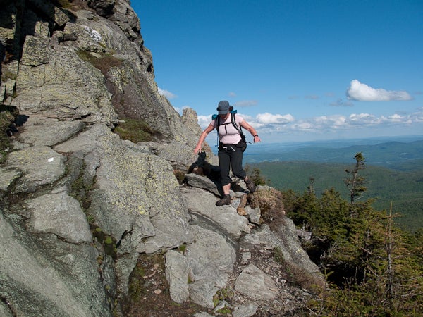
Sidehill Scramble
Location: 44.319548, -72.887579
Managing exposed sidehill slab on Camels Hump
Cowles Cove Shelter
Location: 44.254562, -72.905809
Climbing Burnt Rock
Location: 44.265528, -72.895622
Blazes on Burnt Rock
Location: 44.266092, -72.895392
The LT’s white blazes are painted on the bare rock on the way up Burnt Rock.
Trail Ladder
Location: 44.2721543, -72.8958321
Dropping down a trail ladder into Ladder Ravine
Ethan Allen Overlook
Location: 44.294369, -72.883511
Montclair Glen Lodge
Location: 44.3012473, -72.8827
Up the Hump
Location: 44.306348, -72.882669
Steep rock scrambles are the name of the game.
Hump Ahead
Location: 44.307335, -72.883171
The prominent summit is present throughout the climb.
The Final Push
Location: 44.319371, -72.886776
Approaching the Camels Hump summit
Views on the Descent
Location: 44.3293741, -72.8788376
The descent from Camels Hump offers great views as well
Hump Cairns
Location: 44.330366, -72.878692
Cairns marking the route down from Camels Hump
Steep Roots
Location: 44.359957, -72.868681
ADVERTISEMENT
The descent down towards Bolton steepens here.
The Long Trail in Green
Location: 44.361018, -72.868168
LT Overlook
Location: 44.398694, -72.912363