Published September 20, 2013 02:46AM
Long Trail Compilation
This is a compilation of all 12 sections of the Long Trail hike.


Trail Facts
- Distance: 401.2
Waypoints
LNG001
Location: 42.716101, -73.185277
From the parking lot on Pine Cobble Road, cross the street, and turn left to walk north alongside the pond toward the Pine Cobble Trailhead.
LNG002
Location: 42.716487, -73.185296
At the Pine Cobble Trailhead, turn right off the road and walk around the other side of the pond. Shortly ahead, the route heads east up an increasing climbing grade.
LNG003
Location: 42.722006, -73.166887
Turn right for a .1-mile detour to the Pine Cobble summit; turn left to continue heading northeast and join the Appalachian Trail.
LNG004
Location: 42.727277, -73.161068
At the junction with the Appalachian Trail, continue heading north/northeast.
LNG005
Location: 42.743827, -73.155505
Cross into Vermont and onto the official Long Trail.
LNG006
Location: 42.746791, -73.150353
Continue through stream crossing.
LNG007
Location: 42.768948, -73.136928
ADVERTISEMENT
Continue across dirt road; the Seth Warner Shelter is just head. Beyond the shelter, the Long Trail crosses a dirt road again.
LNG008
Location: 42.791211, -73.118651
Here the climbing eases at a long power line clearing with a view.
LNG009
Location: 42.808477, -73.117221
The trail cuts right, leaving the logging road.
LNG010
Location: 42.82781, -73.123786
Continue straight across the logging road.
LNG011
Location: 42.840673, -73.112569
Continue across jeep road crossing.
LNG012
Location: 42.848009, -73.109767
The Long Trail passes the Congdon Shelter. Continuing west on a slight uphill grade, the trail crosses a logging road just ahead.
LNG013
Location: 42.858493, -73.130133
Continue north across a poorly marked logging road crossing. The trail crosses the road again in another 100 yards or so.
LNG014
Location: 42.871167, -73.132425
From the top of Harmon Hill, the trail descends gradually, then down very steep steps for the last half-mile of section 1.
LNG015
Location: 42.884951, -73.115495
Section 1 ends and Section 2 begins at this parking lot on Route 9. A toilet is available here.
ADVERTISEMENT
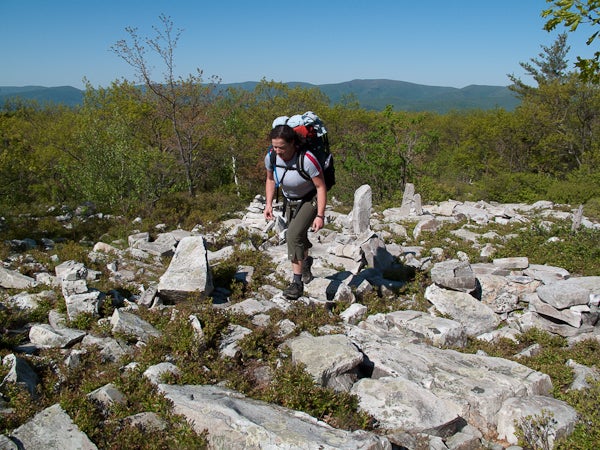
Rugged Terrain
Location: 42.726785, -73.161741
Rough terrain is common on the Long Trail.
Pine Cobble Trail
Location: 42.715474, -73.184447
The Official Long Trail Start
Location: 42.744102, -73.155335
Seth Warner Shelter Junction
Location: 42.771208, -73.134524
Beaver Pond
Location: 42.801563, -73.117107
The Long Trail skirts a large beaver pond.
Long Trail Flora
Location: 42.818014, -73.122417
Harmon Hill
Location: 42.871121, -73.131738
LNG016
Location: 42.884951, -73.115495
From the parking lot on VT-9 (toilet available), the Long Trail crosses City Stream and immediately begins a steep ascent up rock steps.
LNG017
Location: 42.888011, -73.096494
Turn right for the Melville Nauheim shelter; otherwise continue north on the Long Trail.
LNG018
Location: 42.894403, -73.092124
Just below the summit of Maple Hill, the Long Trail enters the Glastenbury Wilderness.
LNG019
Location: 42.906561, -73.087383
Cross Hell Hollow Brook; if you have time to linger (and it’s a hot day), there’s a swimming hole here.
LNG020
Location: 42.974086, -73.072225
ADVERTISEMENT
Shortly after leaving the Glastenbury Wilderness, the trail passes a junction down to the Goddard Shelter here. Just ahead, reach the firetower near the summit of Glastenbury Mountain.
LNG021
Location: 43.014401, -73.043342
Near the bottom of the descent from Glastenbury, the trail passes a junction to the Kid Gore Shelter.
LNG022
Location: 43.023533, -73.037457
Come to a powerline view point with a bench.
LNG023
Location: 43.041551, -73.01921
Here the trail encounters the first of two crossings of South Alder Brook. Ahead, the trail skirts a long beaver pond.
LNG024
Location: 43.050382, -73.012481
A short walk from the end of the section, the trail passes the Story Spring Shelter.
LNG025
Location: 43.053826, -72.990341
The white-blazed Long Trail continues straight across USFS-71. Note: in bad weather, you may want to consider bypassing the exposed summit of Stratton Mountain. To do so, turn left here, continue to the T-junction with Stratton-Arlington Rd., make a right and then a quick left onto a trail route that bypasses Stratton Mountain and rejoins the Long Trail at Stratton Pond.
LNG026
Location: 43.053318, -72.974831
ADVERTISEMENT
Cross Black Brook.
LNG027
Location: 43.053818, -72.971802
Here the Long Trail/AT turn east off of a jeep road.
LNG028
Location: 43.061195, -72.968597
The Long Trail/AT turns east on Stratton-Arlington Rd., crosses East Branch Deerfield River, then heads W @ the far end of the parking lot.
Goddard Shelter
Location: 42.973852, -73.0723
Glastenbury Summit View
Location: 42.977841, -73.071544
Fire Tower Summit
Location: 42.977841, -73.071544
Atop Glastenbury Mountain
Beaver Pond
Location: 43.046132, -73.013792
White Blaze
Location: 43.046561, -73.013826
Kid Gore Shelter
Location: 43.014093, -73.042946
Story Spring Shelter
Location: 43.050388, -73.012304
SBP001
Location: 43.061456, -72.986664
Optional Stratton Mountain Bypass: On gnarly weather days, the exposed summit of Stratton Mountain can be bypassed by this 3.5-mile route that picks up at the intersection of USFS-71 and Stratton-Arlington Road. The bypass route rejoins the Long Trail at Stratton Pond.
LNG029
Location: 43.061165, -72.968582
ADVERTISEMENT
At its crossing on Stratton-Arlington Road, the Long Trail (also the AT) heads east from the Branch Deerfield River, then departs back into the woods from the far end of the parking lot.
LNG030
Location: 43.068466, -72.949165
Cross a jeep road. Ahead, the climb up Stratton Mountain increases in pitch, gaining approximately 1,300 feet in the next 2.1 miles.
LNG031
Location: 43.085934, -72.924896
Stratton Mountain (3,936 ft.): A summit firetower offers great Green Mountain views. Continue downhill, heading northwest from the summit.
LNG032
Location: 43.099983, -72.946182
Shortly after a spring, cross a jeep road to continue west towards Stratton Pond. Ahead the trail meets a small river.
LNG033
Location: 43.102001, -72.96405
Turn right to continue north along Stratton Pond on the Long Trail. This junction also leads to the Stratton Pond shelter. A tenting area is available here via the North Shore Trail.
LNG034
Location: 43.103233, -72.96456
Continue to the right at Stratton Pond. Tenting areas are available to the left and right here.
LNG035
Location: 43.104481, -72.964438
Go right on the Long Trail, heading away from the pond.
LNG036
ADVERTISEMENT
Location: 43.123454, -72.976139
Cross a bridge over the Winhall River.
LNG037
Location: 43.150295, -72.991653
After passing the turnoff for the William B. Douglas shelter, cross a bridge over Bourn Brook. Shortly ahead the trail joins a forest road.
LNG038
Location: 43.154015, -73.008276
The Long Trail turns off the road here heading northeast, passing Prospect Rock (and a great view point) on the left–and the only trash can on the entire Long Trail!
LNG039
Location: 43.179416, -72.994071
The trail to Spruce Peak shelter shoots off to the left towards a fully enclosed shelter with wood burning stove in center, large sleeping lofts, a dining area and front porch.
LNG040
Location: 43.185304, -72.993086
A detour trail leads to Spruce Peak; the white-blazed Long Trail/AT continues northeast.
LNG041
Location: 43.200796, -72.973616
Head northeast towards VT-30/11,
LNG042
Location: 43.206642, -72.970659
ADVERTISEMENT
The LT crosses VT-11/30 and continues from the parking lot on the far side of the road.
LNG043
Location: 43.21427, -72.966485
Cross Bromley Brook; shortly ahead, the trail also crosses a jeep road.
LNG044
Location: 43.22272, -72.951662
Turn right for the Bromley Shelter, or continue up towards the Bromley Mountain Summit. Shortly ahead you’ll pass a broad viewpoint; the final approach to the summit is up a cleared ski trail.
LNG045
Location: 43.227788, -72.939863
Bromley Mountain: From the top of the ski area, the Long Trail heads north down a steep and rocky descent.
LNG046
Location: 43.257604, -72.938177
Section 3 ends at Mad Tom Notch Road (near Mad Tom Notch). There is a water pump here and a grassy area that would make for a nice spot to camp.
Stratton Pond
Location: 43.103509, -72.964405
Crossing Bourn Brook
Location: 43.150459, -72.991747
Prospect Rock View
Location: 43.15402, -73.008268
Balanced Cairn
Location: 43.204096, -72.971963
The AT/LT Continues
Location: 43.208679, -72.968402
Bromley Shelter
Location: 43.222378, -72.950334
ADVERTISEMENT
A Trail on a Trail
Location: 43.228002, -72.941702
The Long Trail cuts through a ski trail on the route up to Bromley Mountain.
Descending Bromley
Location: 43.229472, -72.939324
The initial descent from Bromley Mountain is steep and rocky.
LNG047
Location: 43.258049, -72.938361
Begin hiking north on the white-blazed Long Trail (also Appalachian Trail) from Mad Tom Notch Rd./USFS-21. The trail immediately begins climbing Styles Peak, switchbacking a few times on the steep upper slopes en route to the summit.
LNG048
Location: 43.27363, -72.938019
From the top of Styles Peak, the LT/AT trek along the top of the ridge that connects to Peru Peak, about 1.6 miles north.
LNG049
Location: 43.301247, -72.952841
A steep, rocky, and muddy path leads down to the Peru Peak shelter. Ahead, the LT crosses a series of man-made bridges.
LNG050
Location: 43.303137, -72.958142
ADVERTISEMENT
Pass a nice tenting area alongside Griffith Lake (a nice spot to take a dip on a hot day). Just ahead, continue straight on the white-blazed LT past junctions for both the Old Job Trail and the Lake Trail.
LNG051
Location: 43.323408, -72.965282
The LT continues up Baker Peak past a junction with the top of the Lake Trail.
LNG052
Location: 43.324928, -72.96308
The climbing levels off atop the broad forested summit of Baker Peak. Ahead, the LT heads north on a gradual descent.
LNG053
Location: 43.347075, -72.952588
Pass a junction to the Lost Pond shelter on the left.
LNG054
Location: 43.36327, -72.942868
Turn left on the LT to walk alongside and then cross the Ten Kilns Brook. A right turn here leads to the Old Job lean-to (not maintained by the Green Mountain Club as LT shelters are). There are also nice tenting areas on the stretch alongside the brook.
LNG055
Location: 43.371232, -72.961172
As USFS-10, turn left on the brief road and then, just ahead, right off the road heading north on the trail again. This area is popular with local runners.
LNG056
Location: 43.395456, -72.955113
ADVERTISEMENT
Pass a junction to the Lula Tye shelter (a short walk from the LT). Just ahead there are some tent platforms at Little Rock Pond.
LNG057
Location: 43.403831, -72.953406
Pass a junction with the Little Rock Pond shelter. The Long Trail continues heading northeast before climbing 400 feet up to the top of the White Rocks ridge.
LNG058
Location: 43.44301, -72.942553
Pass a junction with a short (.2 mi) trail to the top of the White Rocks cliff overlook. Ahead the trail descends.
LNG059
Location: 43.442234, -72.933404
Pass a junction to the Greenwall shelter. The Long Trail continues descending.
LNG060
Location: 43.448464, -72.937846
Turn right on the LT/AT, passing the junction with the Keewaydin Trail. The trail meets Bully Brook just ahead.
LNG061
Location: 43.454876, -72.935762
Cross the dirt road (Sugar Hill Rd.) and proceed to the end of the section at the crossing of VT-140.
Little Rock Pond
Location: 43.39878, -72.95527
Bridge Crossing
Location: 43.301399, -72.953902
Peru Peak Shelter Map
Location: 43.301342, -72.952547
Griffith Lake
Location: 43.306068, -72.95866
Up and Onwards
ADVERTISEMENT
Location: 43.323979, -72.964686
Navigating rock slab on the approach to Baker Peak
Brook Crossing
Location: 43.363267, -72.944146
Big Branch Shelter
Location: 43.364198, -72.946515
An old but maintained shelter with a nice swimming area near by.
Boulder Field Cairns
Location: 43.433028, -72.941973
LNG062
Location: 43.456879, -72.932769
The Long Trail leaves from the right end of the parking lot on VT-140 (facing away from the road) and immediately begins a stiff, switchback climb up Bear Mountain (gaining 1,000 feet over the next 1.5 miles).
LNG063
Location: 43.464394, -72.935625
Turn right to continue on the LT. A blue-blazed side trail continues straight.
LNG064
Location: 43.482899, -72.9275
At the junction with the Lake Trail/Patch Hollow, continue straight on the Long Trail. Ahead, the route jogs left than right on and off a logging road.
LNG065
Location: 43.48798, -72.925259
ADVERTISEMENT
The LT passes a junction to the Minerva Hinchey shelter. Ahead the LT climbs a ridge above Spring Lake.
LNG066
Location: 43.51118, -72.927418
The LT passes a westward overlook over an airport outside Rutland.
LNG067
Location: 43.516709, -72.926279
Cross a dirt road; shortly ahead the LT crosses the Mill River and VT-103 before picking up a steep 600-foot climb to the Clarendon Lookout.
LNG068
Location: 43.524166, -72.912964
The LT passes a junction to the Clarendon shelter. Heading east, the LT climbs 400 feet to the top of Beacon Hill, then continues east to cross Lottery Road.
LNG069
Location: 43.53433, -72.873673
Cross a dirt road; shortly ahead the LT crosses a paved road (Cold River).
LNG070
Location: 43.540789, -72.860782
Pass an overlook of the Gould Brook below. Shortly ahead the trail descends to and crosses the brook before following Sargent Brook up a mild grade. Note: the Gould Brook ford can be difficult in high water.
LNG071
Location: 43.550154, -72.856948
Cross Upper Cold River Rd./VT-12.
LNG072
Location: 43.557223, -72.852655
ADVERTISEMENT
Cross Clement Shelter Rd; from here the LT continues uphill, paralleling the road en route the shelter proper. Before continuing past the shelter, consider that a 4-mile, 2,000-foot climb to Killington Mountain lies ahead.
LNG073
Location: 43.589518, -72.817197
Pass the blue-blazed turn-off for Shrewsbury Peak and continue heading west, uphill (for another 300-feet) towards the summit of Little Killington.
LNG074
Location: 43.605611, -72.822401
To continue downhill on the LT towards Cooper Lodge, bear left here. For an .5-mile out-and-back detour to the top of Killington Mountain, turn right.
Ahead the LT descends across the ridge saddle to Snowden Peak before continuing on below Rams Head as it follows contours to the northwest.
LNG075
Location: 43.633598, -72.82994
At a saddle below Pico Peak, pass a turn-off for Pico Camp. Ahead the trail begins a steady 3-mile descent past the Churchill Scott shelter down to US-4.
LNG076
Location: 43.646233, -72.852882
Pass the Churchill Scott shelter.
LNG077
Location: 43.66657, -72.850057
Section 5 ends at US-4.
Killington Peak View
Location: 43.604619, -72.820344
A misty view from the second highest peak in Vermont.
Descending to Patch Hollow
ADVERTISEMENT
Location: 43.476286, -72.933704
The Long Trail on the way down from Bear Mountain.
Minerva Hinchey Shelter
Location: 43.488015, -72.924779
Gap in the Trees
Location: 43.511211, -72.927461
A clearing in the tree cover affords a westward view worth pausing for.
Bob Bruggman Bridge
Location: 43.52124, -72.925217
Crossing the Mill River over a memorial bridge.
Clarendon Lookout
Location: 43.525526, -72.921967
Clarendon Shelter
Location: 43.523613, -72.912676
Governor Clement Shelter
Location: 43.564643, -72.8484
Heading up Little Killington
Location: 43.581774, -72.828018
Cooper Lodge
Location: 43.606038, -72.822746
LNG078
Location: 43.666692, -72.84987
Section 6 begins on the north side of US-4, heading uphill to Willard Gap.
LNG079
Location: 43.674684, -72.839236
At the Maine Junction, the Appalachian Trail splits from the Long Trail. Go left to continue on the LT.
LNG080
Location: 43.679287, -72.843229
Pass the Tucker Johnson shelter.
LNG081
Location: 43.71279, -72.861575
ADVERTISEMENT
Pass Ralston Rest shelter/lean-to. Ahead, the LT makes a short ascent to a no-named ridge before continuing on a northwest track.
LNG082
Location: 43.744639, -72.886549
Exit the woods and go right on a logging roadd and then shortly ahead go left at a junction with the VAST 75 Trail. Ahead, a brilliant view of Chittenden Reservoir comes into sight on your left.
LNG083
Location: 43.759933, -72.901811
The trail curls into Telephone Gap briefly before crossing Billings Brook and beginning another short climb.
LNG084
Location: 43.769234, -72.921195
Pass a junction with a trail heading downhill to the David Logan Hut. Ahead, the trail navigates the western slopes of Mount Carmel to head toward Wetmore Gap. Beyond that, the LT follows a contour around the eastern slopes of Bloodroot Mountain.
LNG085
Location: 43.801934, -72.942676
From Bloodroot Gap, the LT continues tracing contour lines below the east face of Farr Peak.
LNG086
Location: 43.825499, -72.944626
Cross a forest road as the LT begins descending to Brandon Gap.
LNG087
Location: 43.832021, -72.960164
ADVERTISEMENT
The LT passes the Sunrise shelter.
LNG088
Location: 43.839851, -72.968445
Section 6 ends at Brandon Gap.
Chitten Reservoir View
Location: 43.745522, -72.887635
LNG089
Location: 43.839734, -72.968383
From Brandon Gap, continue north on the Long Trail at the intersection with the Cliff Trail. Ahead, the trail makes a steep 600-foot climb up the southern face of The Great Cliff.
LNG090
Location: 43.845332, -72.965099
Continue heading northwest on the Long Trail passing a .7-mile trail up to the summit of The Great Cliff (and a great view to the south across Brandon Gap). Ahead the trail begins a 4-mile ridgeline trek, connecting the summits s Mt. Horrid, Cape Lookout Mountain, Gillespie Peak, and Romance Mountain before heading down to the Sucker Brook shelter.
Note: A seasonal falcon nesting site, Great Cliff is sometimes closed to hikers.
LNG091
Location: 43.892965, -72.971245
ADVERTISEMENT
Pass a junction on the left to the Sucker Brook shelter (downhill). Ahead, the trail climbs the ridge of Worth Mountain.
LNG092
Location: 43.927594, -72.960862
The LT reaches the top of (and begins descending through) the Middlebury Snowbowl ski area.
LNG093
Location: 43.937158, -72.95028
At Middlebury Gap, the LT crosses VT-125 and begins a steep climb up the ridge of Burnt Hill.
LNG094
Location: 43.93777, -72.946134
Continue on the LT, passing a junction with the Great Cliff Trail.
LNG095
Location: 43.959385, -72.944845
Continue on the LT past a junction with the Burnt Hill Trail.
LNG096
Location: 43.96675, -72.94775
The LT passes the Boyce Shelter and continues north up Boyce Mountain.
LNG097
Location: 43.988575, -72.937358
Just past the summit of Battell Mountain, the LT passes a junction down to Skyline Lodge.
LNG098
Location: 44.001027, -72.939735
Just past the summit of Bread Loaf, the LT jogs bag east down to a saddle below Mt. Wilson.
Here a worthwhile spur trail continues northwest for .1 mile to an overlook to the west.
LNG099
ADVERTISEMENT
Location: 44.001445, -72.932199
At the Emily Proctor Shelter, the LT continues heading east from behind the shelter up the slopes of Mt Wilson (following white blazes). Another trail heads north downhill–this is not the LT. If you see blue blazes, you went the wrong way.
From here to the Cooley Glen shelter it’s another 4.5 miles over short but strenuous climbs of Mt. Wilson, Mt. Roosevelt, and Mt. Cleveland.
LNG100
Location: 44.049785, -72.91375
Section 7 ends at the Cooley Glen Shelter.
Mossy Trail
Location: 43.858148, -72.972948
Long Trail Drainage
Location: 43.911305, -72.963521
The LT acts as drainage on the way down from Worth Mountain.
Snowbowl Meadow
Location: 43.934312, -72.95392
The LT cuts through an open field/ski trail in the Middlebury Snowbowl.
Snowbowl Climb
Location: 43.934833, -72.953222
A short steep climb in the Snowbowl, just before Middlebury Gap.
Descending Boyce
Location: 43.974719, -72.940721
The rugged descent from Boyce Mountain
Skyline Lodge
ADVERTISEMENT
Location: 43.98712, -72.936577
LNG101
Location: 44.049785, -72.91375
Section 8 starts from the Cooley Glen shelter and begins an immediate .8 mi, 500-foot ascent of Mt. Grant.
LNG102
Location: 44.052002, -72.92583
Mt. Grant: A summit overlook offers views south of the Breadloaf Wilderness. Continue on the LT heading north on the descent down to Lincoln Gap.
LNG103
Location: 44.087924, -72.927611
About a mile before Lincoln Gap, keep an eye out for the Sunset Ledge overlook (which offers broad views to the west).
LNG104
Location: 44.094921, -72.928287
Use caution crossing Lincoln Gap: ahead the LT begins a 1.7-mile, 1,600-foot climb of Mount Abraham.
LNG106
Location: 44.120409, -72.936237
Mount Abraham: Enjoy 360-degree, top-of-the-world views from one of the LT’s best overlooks. A stonewall offers relief from wind if necessary. Continuing across the top of the ridge to Lincoln Peak, use caution to stay on trail in this above-treeline, alpine plant environment.
LNG105
Location: 44.111785, -72.936855
ADVERTISEMENT
About 750 feet below the Mt. Abraham summit, the LT passes the Battell Shelter. Ahead, the trail begins its approach to “Mt. Abe.” Expect some steep ledge scrambles (tough in wet weather).
LNG107
Location: 44.12709, -72.928705
Arrive at the Lincoln Peak summit above the Sugarbush Ski Resort. The LT continues north along the ridgeline .
LNG108
Location: 44.160188, -72.928859
At the top of Mt. Ellen, the LT pops out onto Suguarbush ski slopes, heads left for 150 feet left and re-enters the woods at an unmarked cairn.
LNG109
Location: 44.179594, -72.930233
Passing the junction with the Jerusalem Trail, the LT continues up the ridgeline towards Stark Mountain. Just ahead the LT meets a junction downhill to the Glen Ellen Lodge.
LNG110
Location: 44.19159, -72.93097
ADVERTISEMENT
The LT pops out onto Mad River ski slopes, turn lefts, cross under single chair. Here the trail passes Stark’s Nest, a warming hut for skiers where camping is allowed. There is an outhouse, but no easily accessible water, but the hut is often stocked with water by the ski patrol. Continue northwest down a steep descent to the Theron Dean shelter.
LNG111
Location: 44.198441, -72.935509
Here the LT passes the Theron Dean shelter. From here the route picks up a steep descent to Appalachian Gap.
LNG112
Location: 44.211293, -72.931379
The LT crosses VT-17 at Appalachian (App) Gap. The LT continues north just down the road at waypoint 113.
LNG113
Location: 44.210902, -72.930611
The LT re-enters the woods and begins a steep climb up a two-tiered climb up Baby Stark and Molly Stark Mountain. This climb is one of the steepest, stretches on the LT. Ahead, the LT passes a junction with the Overlook Trail.
LNG114
Location: 44.225163, -72.925326
Just past the summit of Molly Stark Mountain, reach Molly Stark’s Balcony, an overlook that offers great views of Camel’s Hump to the north/northeast. From here it’s a short descent to Birch Glen Camp, the end of section 8.
LNG115
Location: 44.23659, -72.930078
Section 8 ends at Birch Glen Camp.
Stark’s Nest
ADVERTISEMENT
Location: 44.19159, -72.931108
Sugarbush Signs
Location: 44.140919, -72.927461
Ski Trail Trail
Location: 44.141674, -72.927525
The LT cuts through the upper reaches of Sugarbush
Mad River Glen’s Single Chair
Location: 44.191621, -72.930851
The Realm of the Hump
Location: 44.211251, -72.93145
LNG116
Location: 44.236663, -72.929879
Section 9 departs northeast from Birch Glen Camp heading toward Huntington Gap.
LNG117
Location: 44.240892, -72.909341
The LT crosses Huntington Gap and also the Catamount Trail.
LNG118
Location: 44.25456, -72.905827
The LT passes the Cowles Cove shelter.
LNG119
Location: 44.262763, -72.897048
The LT passes the Hedgehog Trail. Ahead, the climb up Burnt Rock Mountain gets steep with a few scrambling sections.
LNG120
Location: 44.267714, -72.895918
ADVERTISEMENT
Burnt Rock Mountain: Enjoy views north of Ira and Ethan Allen as well as Camel’s Hump. The LT is about to head up all three. Ahead, the LT drops off Burnt Rock via a trail ladder before making a steady ascent of the east slopes of Ira Allen up the “Paris Skidway.”
LNG121
Location: 44.300887, -72.879522
The LT meets the Allis Trail and turns left to continue towards the Montclair Glen Lodge and then then Wind Gap.
LNG122
Location: 44.293875, -72.883859
Mount Ethan Allen: Enjoy the overlook to the east. Ahead, the LT descends north to Wind Gap before the steep climb up Camels Hump.
LNG123
Location: 44.303479, -72.882426
The LT passes a junction for the Forest City Trail; ahead at Wind Gap, the trail jogs west then east to begin clambering up the southern face of Camels Hump.
LNG124
Location: 44.318861, -72.887004
The LT meets a bad weather bypass option (the yellow-blazed Alpine Trail) which leads around the Jump to rejoin the LT heading north. Ahead, the LT skirts below th southern face of the hump and climbs the more manageable (but exposed) rocks on the south/west side.
LNG125
Location: 44.319551, -72.886335
ADVERTISEMENT
Camels Hump: Great views abound from the summit–Mt. Mansfield to the north, Mt. Washington to the east, Mt. Marcy (and other Adirondacks) to the west. The LT continues north across the exposed rock summit area; use caution not to disturb the sensitive alpine plants in this area.
LNG126
Location: 44.321994, -72.885498
Continue through Camel’s Hump Clearing, the site of an old 19th century mountain lodge. from here, the LT begins a steady descent off the Hump on an exposed ridgeline (one of only a few on the entire LT).
LNG127
Location: 44.32907, -72.87918
The LT meets up again with the Alpine Trail (the bad weather bypass around the Hump summit).
LNG128
Location: 44.349474, -72.864935
The LT passes the Bamforth Ridge shelter. Here, the descent mellows and the trail soon widens.
LNG129
Location: 44.361841, -72.87656
The LT turns north to descend through a drainage. Here there is access to the Gleason Brook. Ahead the trail crosses over the Brook via a bridge before finishing the descent.
LNG130
Location: 44.369202, -72.879408
ADVERTISEMENT
Here the LT meets Duxbury Road. Turn left to continue continue 3.2 miles to Cochran Road. There, turn right, walk across the Jonesville Bridge, across US-2, under I-89, and continue north for about .3 mi to re-enter the woods at waypoint 131.
LNG131
Location: 44.388839, -72.933576
Just before the powerlines, the LT heads back into the woods on the right side of the road.
LNG132
Location: 44.39123, -72.91832
The LT passes a junction to the Duck Brook shelter. Ahead, follow and old forest road, cross a stream, and then leave the old road, following white blazes along the way. As the trail climbs ahead, it reaches a trio of valley overlooks. As soon as the LT tops out its climb of the ridge, it turns east to descend to Bolton Notch Road.
LNG133
Location: 44.417972, -72.897446
Cross Bolton Notch Road and continue east on a steady climb. After about 800 feet of climging, the LT turns north up the spine of the ridge, offering a few views west to Lake Champlain.
LNG134
Location: 44.429967, -72.88294
After turning east, the LT passes a junction to an overlook point.
LNG135
Location: 44.430768, -72.876227
ADVERTISEMENT
The LT arrives at a junction to Buchanan Shelter, a good place to spend the night before the climb up to Bolton Mountain.
Sidehill Scramble
Location: 44.319548, -72.887579
Managing exposed sidehill slab on Camels Hump
Cowles Cove Shelter
Location: 44.254562, -72.905809
Climbing Burnt Rock
Location: 44.265528, -72.895622
Blazes on Burnt Rock
Location: 44.266092, -72.895392
The LT’s white blazes are painted on the bare rock on the way up Burnt Rock.
Trail Ladder
Location: 44.272154, -72.895832
Dropping down a trail ladder into Ladder Ravine
Ethan Allen Overlook
Location: 44.294369, -72.883511
Montclair Glen Lodge
Location: 44.301247, -72.8827
Up the Hump
Location: 44.306348, -72.882669
Steep rock scrambles are the name of the game.
Hump Ahead
Location: 44.307335, -72.883171
The prominent summit is present throughout the climb.
The Final Push
Location: 44.319371, -72.886776
Approaching the Camels Hump summit
Views on the Descent
Location: 44.329374, -72.878838
The descent from Camels Hump offers great views as well
Hump Cairns
Location: 44.330366, -72.878692
Cairns marking the route down from Camels Hump
Steep Roots
Location: 44.359957, -72.868681
ADVERTISEMENT
The descent down towards Bolton steepens here.
The Long Trail in Green
Location: 44.361018, -72.868168
LT Overlook
Location: 44.398694, -72.912363
LNG136
Location: 44.430768, -72.876227
Enjoy the morning view from an overlook by Buchanan Shelter and then continue hiking northeast on the LT. Ahead, the trail passes another overlook (the Harrington viewpoint). Ahead, the LT makes an ascent to Bolton Mountain over a rugged up-and-down route.
LNG137
Location: 44.44275, -72.84354
Near a saddle below Bolton, continue on the LT past the Ravens Wind Trail. Ahead the LT climbs steeply to the Bolton summit before descending off the east face on a beautiful ridgeline towards the wooded summit of Mount Mayo.
LNG138
Location: 44.453694, -72.83882
The LT descends a steep rooty and rocky descent past the Puffer Shelter.
LNG139
Location: 44.484917, -72.827382
The LT passes a junction to the Taylor Lodge and then jogs back northwest to continue past Nebraska Notch.
LNG140
Location: 44.486704, -72.833351
ADVERTISEMENT
The LT passes a junction with the Clara Bow trail. Ahead the trail crosses then parallels Clay Brook (and its beaver dams).
LNG141
Location: 44.488639, -72.836659
Pass a junction with the Nebraska Notch trail; ahead the LT skirts the western slopes of Dewey Mountain.
LNG142
Location: 44.502506, -72.828335
Pass the Twin Brooks tenting area. From here, the 3.4-mile climb to Mansfield begins at a gradual grade.
LNG143
Location: 44.513782, -72.81949
Pass a junction to the Butler Lodge and a bad weather Forehead Bypass to the Mansfield summit. From here the route to Mansfield becomes much steeper with rocky corners to clamber around, high exposure, and several trail ladders.
LNG144
Location: 44.515119, -72.817565
Pass a junction with the Wampahoofus Trail; ahead continue climbing steeply to the Forehead.
LNG145
Location: 44.520565, -72.818855
Reach the top of the Forehead, Mount Mansfield’s southernmost peak. Here also, the route meets the Wampahoofus Trail.
LNG146
Location: 44.524835, -72.81636
ADVERTISEMENT
Continue north bearing left on an access road (the Mount Mansfield Summit Station is to the right). Shortly ahead the trail heads back into the woods on the right towards the Visitors Center.
LNG147
Location: 44.527929, -72.815617
Continue north past the Mount Mansfield Visitor Center. From here, continue north along the open spine of the ridge as the LT climbs a few more hundred feet to the true summit of Mansfield. The LT passes the Halfway House trail here (which descends through Underhill State Park).
Ahead, take care to stay off the alpine tundra that dots the open rock trail.
LNG148
Location: 44.529668, -72.817197
Pass the North Canyon trail.
LNG149
Location: 44.535389, -72.817664
Pass the Subway Trail and continue north.
LNG150
Location: 44.543933, -72.814636
ADVERTISEMENT
Mount Mansfield (4,395): At the highest point on the Long Trail, views expand in every direction. Look east to Mount Washington and other White Mountain peaks, west to Lake Champlain and the Adirondacks, and south over the ridge of Green Mountain peaks the LT has already scaled. Closer in to the northeast, spot the “Adams Apple,” a neighboring peak of the Mansfield summit (sometimes called “The Chin”). The LT continues in that direction.
At this point, the route scrambles down an extremely exposed section to the junction with the Hell Brook Trail.
LNG151
Location: 44.545619, -72.811766
Pass the junction with the Hell Brook Trail and continue descending Mansfield’s eastern slopes.
LNG152
Location: 44.543081, -72.809984
Pass the turn off for the Taft Lodge.
LNG153
Location: 44.537204, -72.790818
At VT-108, turn left and head north on the road a short distance to a Smuggler’s Notch parking area (on right).
LNG154
Location: 44.539473, -72.791258
The LT re-enters the woods heading southeast before jogging back north to begin a steep, relentless, 1,600-foot climb up Spruce Peak and then continuing on up Madonna Peak.
LNG155
Location: 44.553272, -72.792588
Above Smugglers Notch, The LT swings east around the upper contours of Spruce Peak. Here the trail passes a junction to the Elephant Head Lookout (closed during Peregrine Falcon mating season).
LNG156
Location: 44.552308, -72.781169
ADVERTISEMENT
Turn left at a junction with the Smugglers Notch ski trail.
LNG157
Location: 44.555611, -72.777958
Continue straight past the junction with the Sterling Pond Trail; the LT skirts the pond just ahead.
LNG158
Location: 44.556892, -72.772779
Pass the Sterling Pond shelter. Ahead, the LT crosses a ski trail as it scales the western slopes of Madonna Peak.
LNG159
Location: 44.561524, -72.758696
Reach the warming hut at the top of Smugglers Notch Resort (also the summit of Madonna Peak). Continue heading east/northeast on the Chilcoot Ski Trail.
LNG160
Location: 44.559301, -72.759855
Turn left on the ski trail to continue up to Madonna Peak.
LNG161
Location: 44.5636, -72.756184
Here the LT leaves the ski trail and heads north into the woods on a descent to Chilcoot Pass. Ahead the route crosses the ski trail one more time before reaching the pass and then climbing Morse Mountain.
LNG162
Location: 44.573807, -72.752754
ADVERTISEMENT
Below the summit of Morse Mountain, come to the Hagerman Overlook of Mount Mansfield (back southwest).
LNG163
Location: 44.578802, -72.740903
The LT comes to the Whiteface Shelter before turning left up a steep 200-foot climb of Whiteface Mountain (the last ascent of the section).
LNG164
Location: 44.582356, -72.740024
At the wooded summit of Whiteface a spur trail leads to a few viewpoints. The LT continues northwest, descending from the summit before curling east to continue downhill.
LNG165
Location: 44.603377, -72.717526
Pass the Bear Hollow shelter; from here, the trail becomes a wide path.
LNG166
Location: 44.620926, -72.72295
Exit the woods and turn right onto the logging road (which becomes gravel ahead).
LNG167
Location: 44.641716, -72.721694
Just before reaching Ithiel Falls, turn left on the Rail Trail to head west.
LNG168
Location: 44.642829, -72.729107
Turn right to head north off the Rail Trail through an open field towards VT-15.
LNG169
Location: 44.64503, -72.728226
Section 10 ends at a parking area on VT-15.
View from Bolton Mountain
ADVERTISEMENT
Location: 44.439742, -72.849337
Pausing at an overlook of the Green Mountains on the climb up Bolton Mountain.
Mansfield View
Location: 44.450119, -72.836661
Looking north to the exposed summit of Mount Mansfield
The Puffer Shelter
Location: 44.453901, -72.838892
Descending from Bolton
Location: 44.454902, -72.838921
The LT gets burly in Section 10
Across the Saddle
Location: 44.457644, -72.837354
Crossing the saddle between Bolton Mountain and Mount Mayo
Descending Mayo
Location: 44.462715, -72.838499
Views north through the trees on the way down Mount Mayo
Trail Ladder
Location: 44.478442, -72.836266
Descending a trail ladder on the eastern face of Mount Clark
Beaver Pond Crossing
Location: 44.482851, -72.83476
Taylor Lodge
Location: 44.484933, -72.826738
Named for the founder of the Green Mountain Club, the Taylor Lodge offers thru-hikers a front porch with a view.
Crossing Clay Brook
Location: 44.486994, -72.835042
Up and up
Location: 44.515672, -72.817947
A trail ladder aids in the steep climb up the Forehead.
ADVERTISEMENT
Above Treeline
Location: 44.5174, -72.817994
The LT enters above treeline terrain for an extended period on the route up Mount Mansfield.
The Forehead
Location: 44.521187, -72.818085
The southernmost peak of Mount Mansfield
Mount Mansfield Visitor Center
Location: 44.527996, -72.815666
Lake Champlain View
Location: 44.530111, -72.817339
Looking west over the Champlain Valley to its namesake body of water.
Exposed on Mansfield
Location: 44.537106, -72.817212
The approach to the true summit of Mansfield (the Chin) is wide open.
White Blazes on Mansfield
Location: 44.541757, -72.815734
Continue following white blazes painted onto the rocks atop Mount Mansfield. Ahead the LT skirts the Stowe Mountain ski area on the descent down to Mountain Road/VT-108.
The Exposed Summit
Location: 44.544872, -72.813876
Looking down the exposed summit of Mount Mansfield
Slippery When Wet
Location: 44.54432, -72.811
Trail Register
Location: 44.539036, -72.79072
Sterling Pond
Location: 44.556557, -72.776411
Ski Trail Hiking
Location: 44.561677, -72.758232
Chilcoot Pass
Location: 44.569812, -72.753457
ADVERTISEMENT
Hagerman Overlook
Location: 44.5739, -72.752667
Looking back to Mount Mansfield
Sterling Pond Shelter Map
Location: 44.556778, -72.772708
Bear Hollow Shelter
Location: 44.603241, -72.717133
The Gravel Long Trail
Location: 44.629035, -72.724372
Rail Trail
Location: 44.641642, -72.722741
LNG170
Location: 44.644964, -72.728205
From the parking area on VT-15 head northwest towards the Lamoille River; ahead, a ladder aids in the descent down to the river. Cross the river and then begin the climb to Prospect Rock.
LNG171
Location: 44.655003, -72.723144
After a steep 200-foot climb, reach the top of Prospect Rock, which affords a nice view of the Lamoille River Valley to the south.
LNG172
Location: 44.657728, -72.721428
Reach the parking lot and turn left on Prospect Rock Rd; shortly ahead, the trail re-enters the woods on the right and begins a moderate climb up Roundtop before descending past the Roundtop Shelter.
LNG173
Location: 44.681342, -72.719376
Cross Plot Road and continue climbing.
LNG174
ADVERTISEMENT
Location: 44.707751, -72.711378
Cross Codding Hollow Road and begin a steep 1,000-foot climb up Laraway Mountain. Just before the top of the climb you’ll reach the Laraway Lookout (with sweeping views to the southeast.
LNG175
Location: 44.725919, -72.711926
From the top of Laraway, continue down the east ridge on a gradual descent. Further on, the LT drops down steeper contours to a forest road.
LNG176
Location: 44.706295, -72.684426
Continue on the LT past Corliss Camp and begin a short climb up Butternut Mountain.
LNG177
Location: 44.722175, -72.654821
Cross Basin Brook and follow blazes as the LT follows a few forest roads to a gravel road. Follow the gravel road for .2 mi and then turn right back into the woods to climb the north slope of Bowen Mountain.
LNG178
Location: 44.724489, -72.635906
Head northeast on the LT atop the ridge of Bowen Mountain. Ahead the LT descends to Spruce Ledge Camp.
LNG179
ADVERTISEMENT
Location: 44.745429, -72.611428
Reach a junction with a Spruce Ledge Camp; the LT continues descending here soon curling east to navigate boulder obstacles in Devil’s Gulch.
LNG180
Location: 44.748812, -72.602798
West of Ritterbush Pond, pass a junction for the Babcock Trail. Ahead, the LT climbs north away from the pond.
LNG181
Location: 44.76385, -72.586754
Cross VT-118 and begin the 1,800-foot climb up Belvidere Mountain.
LNG182
Location: 44.774073, -72.553286
At the saddle below the bummit of Belvidere, reach a 4-way junction with the Foresters Trail. Turn left to descend from Belvidere on the LT.
LNG183
Location: 44.799622, -72.550964
Section 11 ends amongst beaver dams at Tillotson Camp.
Laraway Lookout
Location: 44.72516, -72.716681
Pausing at the Laraway Lookout Perch
Crossing the Lamoille
Location: 44.651314, -72.72902
Prospect Rock View
Location: 44.6551, -72.72327
The Lamoille River Valley from Prospect Rock
Green Mountain Vista
Location: 44.672682, -72.726402
Tiny Cascade
Location: 44.701901, -72.718572
In the Ferns
ADVERTISEMENT
Location: 44.705579, -72.715899
Laraway Lookout View
Location: 44.724997, -72.716961
Corliss Camp Junction
Location: 44.706066, -72.68424
A Fern Path on the LT
Location: 44.709405, -72.661646
Bowen’s South Summit
Location: 44.724418, -72.635593
Side Trail to Spruce Ledge
Location: 44.745255, -72.610651
Devils Gulch Scrambling
Location: 44.745973, -72.607741
Boulder Squeeze
Location: 44.745711, -72.606552
A tight pass in Devil’s Gulch
Gulch Roots
Location: 44.746292, -72.605829
Enormous roots add to the navigation challenge of Devil’s Gulch.
Belvidere Lookout
Location: 44.776452, -72.555707
Tillotson Camp Junction
Location: 44.799622, -72.551651
LNG184
Location: 44.799111, -72.55096
Section 12 begins heading north/northeast from the Tillotson Camp. Ahead the trail ascends Tillotson Peak and then Haystack Mountain.
LNG185
Location: 44.823978, -72.538605
Summit Haystack Mountain and pass a junction with the Haystack Summit Trail. Ahead the LT descends to Hazens Notch.
LNG186
Location: 44.841374, -72.52505
Cross VT-58 and continue as the LT jogs west before turning back east to climb Sugarloaf Mountain.
LNG187
Location: 44.849711, -72.515125
ADVERTISEMENT
Pass a junction with a side trail to the Hazens Notch Camp. Ahead, the LT climbs Buchanan Mountain.
LNG188
Location: 44.878787, -72.509985
Reach the summit of Buchanan Mountain; just ahead, the LT passes an overlook atop Chet’s Lookout, a small boulder that affords views to the north. Ahead the LT descends to a saddle before climbing Domey’s Dome and Gilpin Mountain, two summits along the same ridgeline.
LNG189
Location: 44.903805, -72.496818
Reach the top of Gilpin Mountain, then begin descending to VT-242
LNG190
Location: 44.912665, -72.504141
Cross VT-242; just ahead the LT meets a junction to Jay Camp (to the left).
LNG191
Location: 44.913762, -72.510253
From Jay Camp, ascend to the north end of the Jay Loop and then continue northwest on the LT heading up Jay Peak (a 1.6-mile, 1500-foot climb). Near the top of the climb, the LT criss-crosses ski trails before the summit.
LNG192
Location: 44.924013, -72.525412
ADVERTISEMENT
Jay Peak (3,858′): Enjoy views in all directions from the top: Big and Little Jay are to the northwest. Descend following white marks down slope. At a T-junction ahead, worm through the snow fence to continue. This section is not currently marked.
LNG193
Location: 44.937237, -72.534765
The LT passes the Laura Woodward shelter. Ahead the trail climbs to skirt the summit of North Jay before continuing northeast.
LNG194
Location: 44.969649, -72.511694
The LT arrives at the Shooting Star shelter, and then continues heading northeast from behind the shelter (not well marked).
LNG195
Location: 44.97567, -72.508159
Reach the summit of Burnt Mountain; then walk northeast along the top of the ridge before descending northwest to VT-105.
LNG196
Location: 44.986874, -72.504301
Cross VT-105 and then begin climbing Carleton Mountain.
LNG197
Location: 44.992066, -72.492201
Summit Carleton Mountain; pause at the overlook or continue northeast on the LT. Ahead the trail begins its final descent.
LNG198
Location: 45.008666, -72.488187
The LT skirts the U.S./Canadian border before turning east for its final stretch.
LNG199
Location: 45.004342, -72.466663
The LT passes a junction to Journey’s End Camp.
LNG200
Location: 45.002394, -72.465963
ADVERTISEMENT
The LT ends at a trailhead/parking lot on Journey’s End Road.
Views from Jay Peak
Location: 44.922817, -72.524266
Looking south from Jay Peak
Tillotson Camp Junction
Location: 44.799906, -72.551454
Chet’s Lookout
Location: 44.880979, -72.506673
An overlook atop Buchanan Mountain
Domey’s Dome
Location: 44.891634, -72.499509
Long Trail at Dusk
Location: 44.90902, -72.501312
Scrambling up Jay
Location: 44.922645, -72.5243
On top of Jay
Location: 44.923454, -72.524956
Laura Woodward Shelter
Location: 44.937071, -72.534875
Shooting Start Shelter
Location: 44.969717, -72.511654
Through the Ferns
Location: 44.99255, -72.498686
Latitude 45
Location: 45.002926, -72.489683
The LT passes through the mid-way point between the equator and the north pole.
Border Obelisk
Location: 45.008809, -72.488179
An obelisk marking the U.S./Canadian border
Long Trail Register
Location: 45.003599, -72.466189
A trail register at the north end of the Long Trail.