Lake Chelan National Recreation Area: Rainbow Falls Loop

Located near the headwaters of Lake Chelan in the North Cascades, this 7.2-mile loop travels across remote landscapes accessible only by boat or plane. After a scenic, 50-mile boat ride to Stehekin, hop on the shuttle for a quick ride to Harlequin Bridge. The hike starts at the bridge and follows Stehekin Valley Road to the northwest for 0.5 mile to the Rainbow Falls Loop.
From there, climb through lush forest and meadows speckled with calypso orchids, vanilla leaf, and wild ginger, and then cross the rushing waters of Rainbow Creek on a wooden footbridge. At mile 4, take a worthy side trip to a rocky knob overlooking the lake, then tackle a steep descent back to the valley floor. The hike culminates at the foot of Rainbow Falls, a two-tiered waterfall that plummets more than 300 feet to the ground. Savor the views before following the road back to the shuttle pick-up at Harlequin Bridge.
Info: Lady of the Lake and Stehekin Shuttle
-Mapped by Alan Bauer, Alan Bauer Photography

Trail Facts
- Distance: 11.5
Waypoints
RBW001
Location: 48.34943, -120.713539
From the historic Harlequin Bridge, hike northwest along the Stehekin River on Stehekin Valley Road.
RBW002
Location: 48.354935, -120.721405
Turn right onto Rainbow Falls Loop Trail @ 3-way junction. Note the colorful trail sign-each of the letters in “rainbow” is painted with a different color. Next, leave the road and begin an ascent through open fir-pine forest; vanilla leaf and trilliums cover the ground on this stretch. Prepare for a switchback climb ahead.
RBW003
Location: 48.356323, -120.716057
Skip across a small, seasonal creek, then head southeast through lush forest covered with calypso orchids, vanilla leaf, wild ginger.
RBW004
Location: 48.348171, -120.699898
Break out of the forest into an open meadow area; here, the trail traverses the hillside before dropping down into the forest again. Look for deer above the trail; yellow bells, arrowleaf balsamroot, lupines, and glacier lilies speckle the ground.
RBW005
Location: 48.348038, -120.696747
Turn right @ Y-junction. Continue downhill toward creek. The trail on the left climbs steeply up the valley above Rainbow Creek.
RBW006
Location: 48.347664, -120.693733
Cross a wooden footbridge over the roaring Rainbow Creek (from here, the creek runs southwest for 0.4 mile to Rainbow Falls).
RBW007
Location: 48.344212, -120.690742
Stay right @ 3-way junction (the trail to the left heads up Boulder Creek). Enjoy a leisurely descent that switchbacks down to an open forest of pine and firs. You may spot wildflowers and grouse in the forest.
RBW008
Location: 48.340359, -120.689522
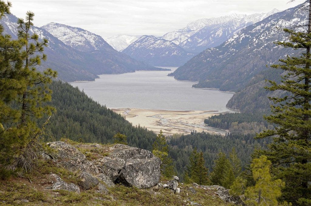
Follow the short side trail to a high rocky knob with spectacular views to the south over Stehekin and Lake Chelan. Desert bluebells cover the wind-blown landscape. Look closely for fence lizards lounging in the sun (you may also spot rattlesnakes in late spring). Ahead: Continue switchback descent to the valley floor.
RBW009
Location: 48.332279, -120.692436
Turn right onto the paved Stehekin Valley Road @ the Rainbow Creek Trailhead. Hike north along this quiet road.
RBW010
Location: 48.340725, -120.697968
Recommended: Turn left @ 3-way for a side trip to the historic Stehekin Schoolhouse. Go inside to learn about this K-8 school that served the valley for decades; turn out the lights and shut the door behind you when you leave. Return to Waypoint 10 and turn right onto Stehekin Valley Road.
RBW011
Location: 48.340546, -120.700272
Turn right @ signed dirt road that leads 0.1 mile to the Rainbow Falls parking area. Follow the short trail to Rainbow Creek Falls–a two-tiered waterfall that plummets 312 feet to the ground. Return to Waypoint 11 and turn right. Continue northeast along paved road back to the Harlequin Bridge. Catch the shuttle to return to the boat landing.
Views of Lake Chelan
Location: 48.340378, -120.689484