Published September 20, 2013 05:23AM
Joshua Tree National Park: Fortynine Palms Oasis
Hike past massive boulders, red barrel cacti, and restless tumbleweeds to a shady oasis on this 3-mile out-and-back in Joshua Tree National Park.
This easy to reach, palm-covered oasis is the perfect destination for those short on time in Joshua Tree National Park. And, if you start early on this 3-mile out-and-back, you may witness endangered desert bighorn sheep enjoying the shade and water at the oasis.
Hike to Fortynine Palms Oasis
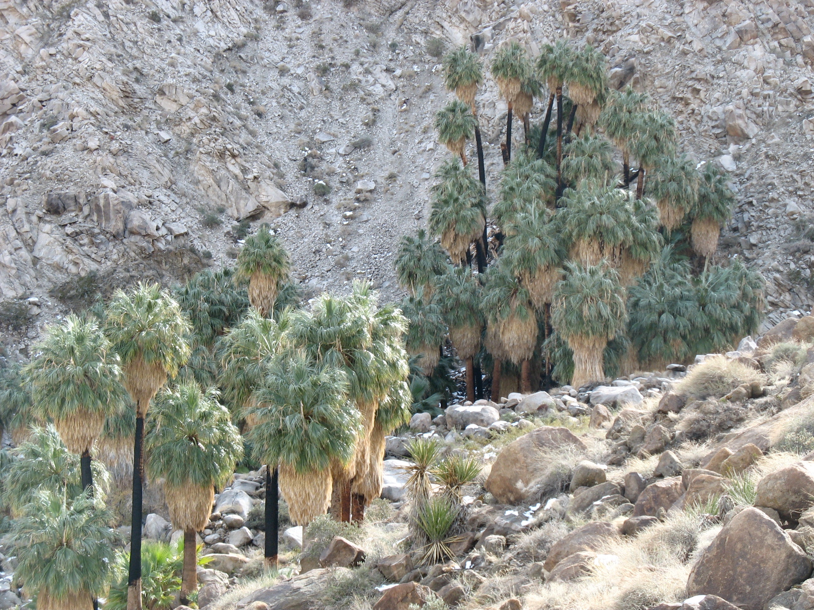
At the parking lot, take in the expansive views of Morongo Basin to the north, before heading south on the trail. The pebble-strewn path gradually ascends 0.7 mile through a boulder field to the top of a scrub-covered hill. After a few steps, look into the distance for views of the oasis, tucked in a small canyon less than a mile ahead. From here, a switchback descent past plump, red barrel cacti ends at Fortynine Palms Oasis. Drop your pack and relax under the welcoming canopy of massive California fan palms (these giants can weigh up to 3 tons) before heading back to the trailhead.
-Mapped by Amy Balfour


ADVERTISEMENT
Trail Facts
- Distance: 4.8
Waypoints
FP001
Location: 34.1192303, -116.1120129
ADVERTISEMENT
In winter, expect strong winds throughout much of the park. Hang on to hats and other loose items so they don’t get blown away.
FP002
Location: 34.1169209, -116.1083651
Climb 350 feet to the top of a ridge.
FP003
Location: 34.1174894, -116.1065412
Turn right at the top of the hill. As you hike the windy ridgeline, hold on tight to anything loose.
FP004
Location: 34.1154465, -116.1065519
If you look south and squint, you’ll catch the first views of the green, mop-topped fan palms in the canyon below.
FP005
Location: 34.107168, -116.106306
Pay attention: The rocks along this stretch look alike, which can make trail finding tricky on the return trip.
FP006
Location: 34.106297, -116.1054468
A broad, flat rock inside the first cluster of palms is a nice spot for a picnic. Look closely: Some of the palms have charred trunks while others have graffiti carved into them.
FP007
Location: 34.1058795, -116.1050069
ADVERTISEMENT
Scramble over boulders to get to a second grove of palms and small seeps created by the springs. Follow the same route back to the trailhead.
Fortynine Palms
Location: 34.1071676, -116.1061871
Can you count 49 palms?
Trailhead
Location: 34.1192214, -116.1118841
Check out the sweeping view of the Morongo Basin to the north of the trailhead.
Boulder Field
Location: 34.1176226, -116.1108971
The trail twists through an imposing cluster of boulders before a short ascent.
View of Morongo Basin
Location: 34.1169209, -116.1082363
The town Twentynine Palms is visible in the distance.
First View of the Oasis
Location: 34.1154465, -116.1064231
Final Push to Oasis
Location: 34.1122576, -116.1075604
The trail gradually descends to the oasis. Red barrel cacti along the trail add a dash of color to the gray-brown landscape.
Welcome to Fortynine Palms
Location: 34.1084112, -116.107378
Palm-Framed view of Morongo Basin
Location: 34.1062881, -116.1053288
Ridgetop view of Morango Basin
Location: 34.1157485, -116.1060369
The sprawling Morongo Basin dominates the view from the ridge on your return.