Published November 6, 2018 10:33PM
The Insider's Guide to Moab
Skip the beaten path and make the most of your visit to southwest Utah with these tips from a local.
'Grant Ordelheide / Tandemstock.com'
No other trail town is as synonymous with desert paradise as Moab: Within easy striking distance of Arches and Canyonlands National Parks, the Bears Ears buttes, and acres of empty Bureau of Land Management land, the town sits at the heart of A-list canyon country. You can’t keep real estate like this secret for long, though, and in recent years, parts of the wilderness have become downright crowded. The good news: There’s plenty of redrock utopia to go around—if you know where to look.
The Insider
Mike Coronella has spent the last 15 years ferreting out Moab’s secret spots. As both the owner of local outfitter Deep Desert Expeditions and a volunteer with Grand County Search and Rescue, he knows almost every inch of the canyons and mountains around his hometown, and quite a bit more to boot: He’s also the cofounder of the 800-mile Hayduke Trail through southeast Utah and northwest Arizona.
Easy Day Trip
With a high rock art-to-effort ratio but a low number of hikers per mile, the South Fork of Sevenmile Wash adds up to a Coronella favorite. There’s no official trail on this BLM land, so just follow the sandy bottom up to 5 miles (one way) between canyon walls layered like phyllo dough. From the unmarked trailhead on UT 313 (near 38.6492, -109.7222), wind past petroglyph and pictograph panels, keeping your eyes peeled for human figures, geometric shapes, and bighorn sheep adorning the desert varnish. (Leave all rock art undisturbed, of course.)
Quiet Overnight
A geologic mystery lies in Canyonlands National Park’s Island in the Sky District: a 3-mile-long zone of wildly tilted rock layers that don’t match the rest of the park. “Everything is turned inside out,” Coronella says of the area, called Upheaval Dome. The theories about its origin involve a meteor impact or a layer of ancient salt rising to the surface. Form your own ideas on the 8.3-mile Syncline Loop, which traces the canyons around Upheaval Dome, careening up and down cliffy switchbacks and winding through boulderfields. Camp at the Syncline site and save time to tour the inner dome on the 1.5-mile spur. “Dayhikers never go in there,” Coronella notes.
ADVERTISEMENT
Wild Week
Ready for a big bite? Tackle the 50-miler from Cathedral Butte to the Colorado River in Canyonlands’ Needles District. The point-to-point route showcases canyon country’s finest, from rock art panels to sandstone arches to striated hoodoos. “It’s an astonishing series of canyons, drainages, and ridgelines with huge views,” Coronella says. From the trailhead on the district’s southern border (37.9500, -109.7062), drop into Salt Creek and spend two days exploring a remote canyon rich with ruins and art panels (like the famed All American Man). Camp at the Salt Creek 1 campsite, then near the spur to Angel Arch. Next day, head west into Lost Canyon, a series of slickrock benches overlooking deeper chasms, and camp at Lost Canyon 1. Continue west among Chesler Park’s pillars, tossing in the short side trip to Druid Arch en route, and sleep at Chesler Park 1. Head northwest on Lower Red Lake Canyon Trail to spend the last night in the open zone before finishing on the banks of the Colorado, just south of its confluence with the Green River. Hop a prearranged jetboat shuttle (texsriverways.com) back to Moab (there’s no other way out).
Counterprogramming
Shhh: There’s more to Moab than the desert. The lonely La Sal Mountains rise southeast of town and see a fraction of the traffic the canyons do. For top-of-Utah views, head for 12,645-foot Mt. Mellenthin via Gold Basin, a 3-mile (one-way) ascent through aspen stands, then evergreens, then open talus. You’ll tag Pre-Laurel Peak and Laurel Peak before swinging northeast and negotiating steep scree slopes to the top. There, you’ll find vistas extending into Colorado’s San Juan Mountains and Utah’s Henrys.
Stargazing
Coronella maintains that the celestial show is excellent “everywhere” in the Moab region, but, when pressed, he recommends the 360-degree view from the La Sal Mountains Viewpoint in Arches National Park. “The stars here are surreal,” he says.
ADVERTISEMENT
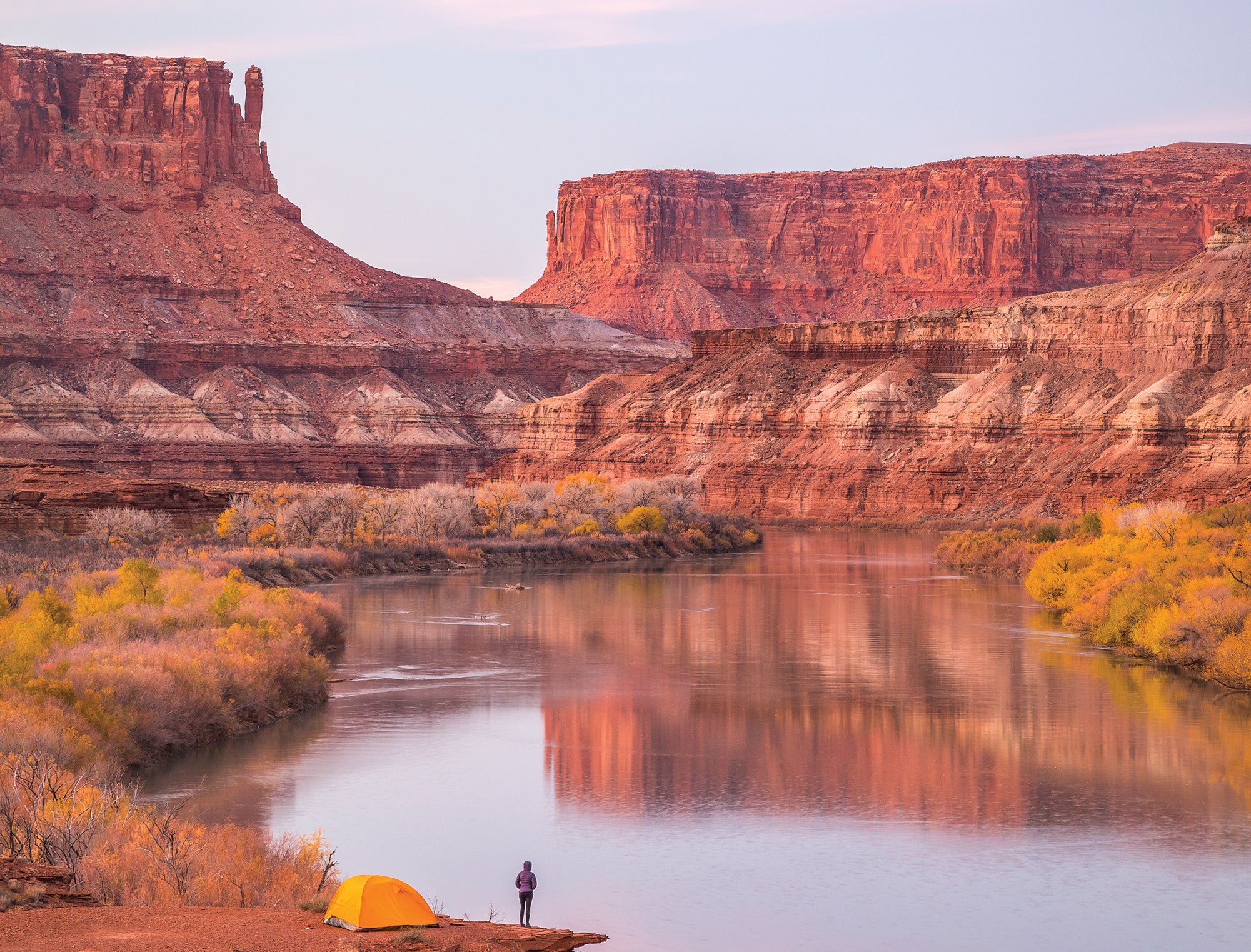
Photo Opp
Canyonlands’ White Rim Road is popular with drivers and mountain bikers, but with just 20 campsites along the 100-mile route, solitude is guaranteed if you score a permit. Gun for the Labyrinth area (pictured), applying as many as four months in advance, to enjoy a private vista over the Green River.
Trip Planner
Season March to May and September to November Permit Required for backpacking at Canyonlands ($30/group; reservations recommended)