Published April 21, 2016 07:13PM
Indianapolis, IN: Primo Lakeside Camping (Charles C. Deam Wilderness)
Camp on the tip of this peninsula on a quick overnight in the Charles C. Deam Wilderness. BY STUART PECK
'Charles C. Deam Wilderness'
I understand the attraction of loops—new scenery every step, no retracing your route, a sense of continuity. But I would argue that out-and-backs are better. Pick the right end point, and an out-and-back is more than a linear hike. It’s a mission. Every step brings you closer to the prize, and here in the Deam, just an hour and a half outside Indy, the prize is best-in-class camping: a private peninsula, where I plan to kick my feet up (or maybe dangle them in the water), catch the best star show in Indiana, and cook over an open fire. Then I’ll linger lakeside in the morning; no rush, I know exactly how long it will take to retrace my steps.
Trip stats
Distance: 17.4 miles (out and back)
Time: 2 days
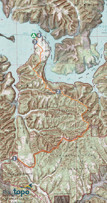
Turn-by-turn
From the Grubb Ridge trailhead
(1) Follow the Grubb Ridge Loop Trail 5.9 miles to an intersection.
(2) Hang right and pick up the Peninsula Trail; take it 2.5 miles to its terminus at a beach on one of the fingers of Lake Monroe.
(3) Head .3 mile north on the shore to a campsite at the tip of the peninsula.
(4) Retrace your steps to your car.
Campsite
Hoosier National Forest Campsite #1 (mile 8.7)
We’re calling it now: This may be the best campsite in all of Indiana. It might even top the list in the Midwest. Surrounded by water on all but one side, you’re almost guaranteed primo sunrise and sunset views across North Fork Salt Creek, the top portion of 10,000-acre Lake Monroe, the state’s largest. Seventy-foot pines, poplars, and maples shelter your camp from lake winds (there’s space for six tents).
Wildlife
From your campsite, scan for bald eagles floating on thermals and geese and grebes in the shallows. Look for white-tailed deer and foxes in the nearby trees.
DO IT Trailhead 39.016933, -86.389511; 16 miles south of Bloomington on Tower Ridge Rd. Season Early April to November Permit None Custom mapbit.do/BPmapTheDeam ($15) Contactfs.usda.gov/hoosierTrip databackpacker.com/thedeam
ADVERTISEMENT
Trail Facts
- State: IN
- City: Indianapolis, IN
- Distance: 17.4
- Contact: www.fs.usda.gov/hoosier
- Land Type: Wilderness Area