Published June 30, 2010 01:23PM
Hiking Wild Wales: Snowdonia National Park
The highest peak. The wildest ridges. The largest lake. Find them all in Wales's alpine heart.
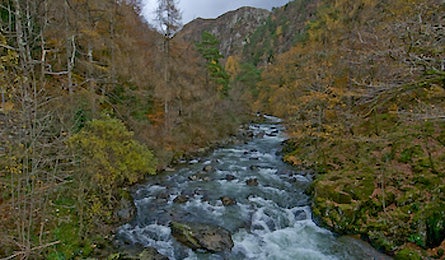
' The Pass of Aberglasslyn, Snowdonia. Old stomping grounds of the poet Shelley. (Steve Howe)'
Pembrokeshire Coast Path | Snowdonia National Park |Brecon Beacons National Park |Offa’s Dyke Path | Plan It: Wales
Only have time for one hike? Make it here, in the epicenter of trekking and mountaineering in Wales. Between 1905 and 1909, Mallory earned his climbing stripes here while on university vacations. Eventually, like Hillary in later years, he trained for Everest expeditions by scaling Snowdonia’s peaks in brutal winter conditions. Of course, you don’t need to be an aspiring alpinist to see the best of the park—though we recommend you do it spring through fall.
[high traverse]
Across the Glyders
No debate: This 9.6-mile scrambly route would be world-class anywhere you found it. The name Glyders comes from a Welsh word meaning “pile of stones,” which hardly does justice to the striking rock formations atop this range of nine jagged summits that rise 2,000 vertical feet above the valleys below. The route threads between Glyder Fawr and Glyder Fach, the two highest peaks, before wandering along treeless tundra and descending through a massive, abandoned slate quarry. End at Llanberis, a mountain town set lakeside beneath Dolbadarn Castle.
From the Birmingham Outdoor Education Centre at the foot of Llyn (Lake) Ogwen, climb southeast up the ridge of Y Cribn, which quickly takes you to the high plateau between Glyder Fawr (3,278 feet) and Glyder Fach (3,261 feet). Most hikers do this route in a day, with good reason: Wind routinely rips across the exposed ridge at a tent-shredding 40 mph (and dispersed, or “wild,” camping is frowned upon inside the national park). Follow the path west along the ridge, over Glyder Fawr, and continue as it wraps northwest. Otherworldly natural rock sculptures dot the ridgeline, and the terrain drops away precipitously on either side, making this a hike you’ll want to linger over.
ADVERTISEMENT
After a descent past the pond of Llyn y Cwn, and one more climb, the path traverses downward on sheep trails to break out atop the 19th-century Dinorwic slate quarries. The 700-acre complex of cliffs, ponds, tunnels, and ruins, including what was once the world’s largest man-made cavern, offers an intriguing—and oddly scenic—glimpse into local history. After the descent, a .7-mile walk takes you into downtown Llanberis. Pete’s Eats is the local hotbed for posthike feeding. Don’t miss their map and guidebook lounge on the second floor; it’s a mountain-lover’s library for researching peaks and treks from Wales to the Himalaya.
[prehistory]
The Bronze Age Road
See one of the most haunting ancient monuments in the United Kingdom on this cross-country trek. Bryn Cader Faner, the megalithic “ring cairn” at trip’s end, sits like a crown of broken stone teeth atop a lonely, often fog-bound ridgeline. The five-mile hike can be done as a short round-trip or as a dramatic finish to a multiday, 19-mile traverse of the Rhinog Range. (Begin the longer trek at Bontddu, to the south, along the A496 between Barmouth and Llanelltyd.) For the dayhike, start at a pond 1.8 miles north of the Maes-y-Neuadd Hotel (off A496 south of Penrhyndeudraeth). Walk east on the country lane to a signed turn for Caerwych Farmhouse/B&B; ascend switchbacks to the stone inn and follow the hiker’s sign past the barn, continuing uphill toward the high point of the ridge. Beyond the last of four stone fences, the path turns left but is harder to follow. Aim for the pass to the southeast. After a creek crossing, the trail turns sharply south and follows a deeply cut road—the remains of a medieval-era wagon track. Follow this trench uphill and trend left toward the pass. In clear weather, you’ll soon spot the eerie, ancient standing stones.
[Arthurian scramble]
The Snowdon Horseshoe via Crib Goch
With airy ridges and a knife-edge tiptoe, this seven-mile route is like an alpine fantasy come true. And if you’re a sucker for ancient mythology as well as mountain challenges, it doesn’t get any better. In Welsh, Snowdon, the highest mountain in the country, is called Yr Wyddfa: “the burial place.” According to legend, King Arthur and his knights fought their last battle on Snowdon’s slopes and were entombed there. The Snowdon Horseshoe loop ascends Crib Goch, goes over the peak, and descends the rugged ridgeline of Y Lliwedd. Warning: While in nonwinter conditions this hike requires no technical gear, you need solid scrambling skills and comfort with serious exposure.
Begin from the Pen y Pass trailhead and follow the broad Pyg Track toward Snowdon, but take the first major fork to the right, at a stile where a fence crosses the main trail. Follow the steep track up and right, onto the black buttress overhead, then scramble up the hard black rock on solid handholds. Top out on the east end of the Crib Goch ridge, make your way along the arête, clamber over the airy Pinnacles, and cross the second knife-edge ridge of Crib y Ddysgl. The ridge broadens until you reach Snowdon’s 3,560-foot summit, which has head-spinning 360 views, but can feel a bit anticlimactic because of a tourist train that delivers the only crowds you’ll see on this route.
ADVERTISEMENT
From the peak, drop southwest for several hundred yards, then find a faint path that cuts across the south face of Snowdon to Bwlch y Saetheau (Pass of the Arrows) where—according to legend—Arthur made his last stand. Climb on good trail across the summit of Y Lliwedd, and follow the ridge until you see a path that turns left and descends to the lake of Llyn Llydaw. There, you’ll intersect the Miner’s Track and follow it back to Pen Y Pass to close the loop.
[solitude]
Nantlle Ridge
Get off the beaten track and score big views on this eight-miler, which traces open ridgelines with unobstructed vistas across Snowdonia and the Irish Sea. Start southwest of the village of Rhyd Ddu, and follow the obvious path up the east ridge of Y Garn. Turn left (south) and follow the massive ridgeline over numerous mini summits, including Craig Cwm Silyn, the ridgeline’s high point at 2,408 feet, before dropping down to a roadside pullout northwest of Garndolbenmaen village.
[tackle a local crag]
Lockwood’s Chimney
What do area climbers do when the peaks are getting blasted? Head to this half-cliff, half-cave climb for some scary laughs. Ascend a steep cleft that splits the Clogwyn y Bustach crag in the Nant Gwynant Valley on this only-in-Wales classic. Most of the climb is simple, but a short chimney crux is rated “severe” in the old English climbing system (translation: awkward, slippery 5.6-5.7). Bring two full-length ropes, helmets, harnesses, and a small collection of runners and wired nuts for safety on stepped cliffs that start the climb, and for the chimney itself. Headlamps make it easier to see your holds. From the top, a 60-meter rappel returns you to the climb’s base. Trailhead: Park near the historic stone Cwm Dyli hydropower station along the A498. (Get a guide: proadventure.co.uk.) Local color: In honor of the 1908 first ascent by Arthur Lockwood (one-time proprietor of the nearby Pen y Gwyrd Hotel and climbing center), the chimney is traditionally tackled at night, in stormy weather, drunk, and naked. We do not advise this.