Published June 30, 2010 01:22PM
Hiking Wild Wales: Pembrokeshire Coast Path
Tiptoe along oceanside bluffs with views across the Irish Sea.
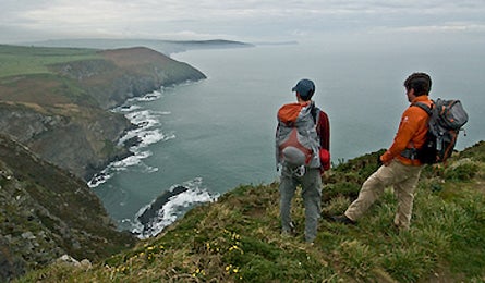
' Overlook onto the Irish Sea, Pembrokeshire Coast Path near Moylegrove. (Steve Howe)'
Pembrokeshire Coast Path | Snowdonia National Park |Brecon Beacons National Park |Offa’s Dyke Path | Plan It: Wales
With surprisingly Caribbean beaches and cliff-brink walking, the Pembrokeshire Coast Path—one of 15 National Trails in Britain—runs for 186 miles around the perimeter of a large peninsula. Between Amroth Castle in the south and the town of St. Dogmaels in the north, it passes 70 beaches, dozens of overlooks, and more than 40 ruins ranging from prehistoric stone circles to 11th-century Norman castles. Thru-hike the whole thing in two weeks (see page 19 for info), or sample the trail’s best scenery on these shorter sections.
[surf and turf]
Porthgain to Whitesands Bay
This 9.7-mile segment runs from a tidy harbor village to a vast beach, and ends only two road miles from a don’t-miss sixth-century church and museum in St. Davids. From Porthgain’s stone piers, head south to the secluded beach of Traethllyfn, where seals often bask on the black sand. Continuing past the tiny village of Abereiddy, you’ll walk between the Irish Sea and electric-green pastures where shaggy, curved-horn highland cows graze behind ancient stone fences overgrown with yellow gorse. After 6.6 miles, spot the point of St. David’s Head above Whitesands Bay, with Ramsey Island looming beyond.
[cliff walk]
Ceibwr to Poppit Sands
This view-a-second section often runs atop a 500-foot precipice, so you might want to stick to the pub in the most ferocious weather. Even on fine days, the steep 5.5-mile trek is a challenge. From Ceibwr, climb quickly to overlooks of twisted, wave-lashed islands that were formed when cliffs collapsed into the sea. After 4.5 up-down miles, the views crescendo at the craggy point of Cemaes Head. There’s camping in the village of Allt-y-goed, but continue 1.5 miles on a country lane to Poppit Sands. Nearby is the 12th-century Abbey of St. Dogmaels—and The Ferry Inn, a much younger (but still historic) pub.