Published July 9, 2009 04:26PM
Hike It, Save It: Otero Mesa, NM
The threat to this 1.2 million acre wilderness? Oil Drilling. Hike to the top of 6,660-foot Alamo Mountain to see what's at stake.
'Alamo Mountain (Stephen Capra/NM Wilderness Alliance)'
The Details Otero Mesa is “the Arctic National Wildlife Refuge of the Southwest,” New Mexico BLM director Linda Rundell once said. In terms of threat, yes, but it looks more like the Serengeti. Located along the state’s southern border with Texas, Otero provides habitat for a herd of nearly 1,000 genetically pure (and native) pronghorn antelope that roams massive swaths of black gramma grass, the dominant vegetation from Arizona to west Texas before cattle came on the scene. But beneath the 1.2-million-acre unit, far below its superlative flora and fauna, lies the ANWR connection: deposits of oil and natural gas. In 1997, the Harvey E. Yates Co. drew lease applications covering 110,000 acres. So far, the onslaught of wells has been thwarted–hung up in lawsuit limbo–but under current BLM regulations, 95 percent of Otero Mesa remains open to drilling. Rundell says the oil is “pretty small potatoes” compared to the Salt Basin Aquifer, which local drilling could contaminate. It holds 57 million acre-feet of water, enough to fill 30,832,062 Olympic-size swimming pools–and quench Albuquerque’s thirst for nearly 200 years. Nathan Newcomer, of the Coalition for Otero Mesa, says his group is pressing for 520,000 acres to be preserved as designated Wilderness Area units. (The remaining land would be left for a smattering of existing ranches.) The Delaware-size ecosystem also supports 250 bird species, and all of it–grassland, antelope, aquifer–would be threatened by oil and gas wells.
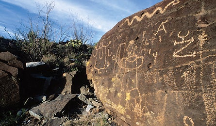
The Hike Trek to the top of 6,660-foot Alamo Mountain–one of a cluster of mile-high volcanic intrusions at the south end of the proposed wilderness unit–for a perfect vantage point from which to peer across Otero’s sprawling scenery. From the parking area on the mountain’s west side, at 5,200 feet, head through the gate with the Alamo ACEC (Area of Critical Environmental Concern) sign. Follow the faint path east and wind clockwise around the conical mountain; there’s no maintained trail, so go slowly on the loose rock. The route ascends through lush grass, cacti, and yuccas as it climbs tiered benches at 5,600 and 6,000 feet. As you arrive at the second level, roughly two miles into the hike, pause to check out some of the thousands of petroglyphs left by ancient Mescalero Apaches (among the identifiable images: bighorn sheep, women giving birth, and some type of fish). When you reach due north on the arc around Alamo, follow a gentle ridge south to the mountain’s flat, broad summit (perfect for a campout–but pack all of your water). There’s a thin piñon-juniper forest on top, and views of the open Otero grasslands to the north, the rest of the Cornudas Mountains to the east, and the vast expanses of Texas and Mexico to the south. Now take a close look to the southwest, by the parking lot. There you’ll see a capped exploratory oil well. As Newcomer unnecessarily states, “Imagine what Otero Mesa would be like if it was filled with those.” The hike is five miles round-trip, but allow plenty of time for a leisurely detour into the black gramma grass. It turns green and shoots up to three feet high in the early fall, which is the most pleasant time to visit. blm.gov/nm/st/en/fo/Las_Cruces_District_Office.html
The Champion The Coalition for Otero Mesa (oteromesa.org, 505-843-8696) works with politicians and the BLM.
The Way From El Paso, drive east on US 180/US 62 43.7 miles, to a hard left onto County Rd. F010, and go 6.8 miles to obvious parking.