Published August 7, 2013 04:56PM
Hidden Montana: Mission Mountains
The Missions stand out even in northwest Montana, a region with no shortage of steep, crazed peaks. Travel in this glacially eroded landscape of dense evergreen forest, hidden lakes, tusk-like 9,000-foot summits and long, knife-edged ridgelines can be described in three simple terms: Steep. Rocky. Strenuous. Basecamping is the best plan.
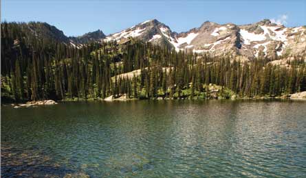
'Turquoise Lake (Jeremie Hollman)'
Turquoise Lake The secretHike to the shore of a half-mile-long lake for mountain vistas and gold-medal cutthroat fishing. A trio of sedimentary peaksstands guard over Turquoise Lake’s expansive waters and long shorelines as though to keep them hidden. Set up basecamp lakeside (there are several campsites; you can’t go wrong) after a 6.4-mile hike, and—if you can tear yourself away from the unobstructed, cast-friendly shore—explore some of the Missions’ highest glacial cirques. Montana locals might quibble about the “hidden” status, since the first mile of Trail 690 can bustle on holiday weekends. The real secret? Most visitors give up at Glacier Lake (mile 1.3), but that’s where this hike gets good. Take the right fork at Glacier Lake junction, continuing uphill to the Glacier Lake viewpoint at mile 2.6. Here, enjoy vistas that encompass a sea of conifers and a swooping granite ridgeline slung between Mountaineer and Panoramic Peaks, 3,000 feet overhead. At the junction that leads to Heart Lake, go right 1.1 miles for lakeside camping, or turn left (Trail 708) and climb to timberline and bare granite domes at 4.4 miles. The Mission Divide looms larger as you approach a lookout over Lagoon Lakes (mile 5.2), which pool into a bare rock shelf at 6,600 feet. Follow the trail, scrambling down rock slabs for 200 yards and 150 vertical feet until the steep shores of Lace Lake come into view on your left. Continue downhill to Turquoise Lake and the mirrored images of Daughter of the Sun Mountain, Panoramic Peak, Glacier Peaks, and Sunrise Glacier. Camp in pine forest at the lake’s eastern end. Plan on spending at least three days for nontechnical excursions to Lone Tree Pass, the ridgelines around Glacier Peaks, and Daughter of the Sun Mountain. Trailhead87 miles northeast of Missoula; 47.381817, -113.793000Map USGS quads Gray Wolf Lake and Hemlock Lake ($8 each) Contact Flathead NF; (406) 837-7500; fs.usda.gov/flathead