Published August 7, 2013 05:19PM
Hidden Montana: Absaroka Range
The little-known Absaroka (ab-SOAR-kuh) Mountains are the largest single range in the Rockies, and they undoubtedly form the wild core of the Greater Yellowstone Ecosystem. In their northern extremities, the Absarokas manifest their grandeur as steep, rugged spires, thanks to cliff-friendly blends of granite and gneiss. There among the pinnacles you'll find all the mountain wildlife of Yellowstone (mountain goats, bighorn sheep, elk, wolves and bears both black and brown), but with bigger, badder scenery and far fewer people.
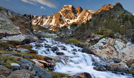
'Black Mountain and Pine Creek (Doug Roane)'
Pine Creek Lake and Black Mountain
The secret:Keep climbing when others turn back to reach the lake-filled foreground—or the top—of this steep, dark-mountain castle.
The image of this craggy, 10,941-foot peak reflects on Pine Creek Lake, the mountain’s 32-acre pond set amid granite slabs. Don’t be fooled by the busy trailhead; most folks turn back at Pine Creek Falls, a mile in. The 4.4-mile, 3,400-vertical-foot approach to the lake means you’ll find isolated camp spots at the water’s edge, with plenty of solitude anytime but the busiest holiday weekends. Ascending Black Mountain itself makes for either a hardcore dayhike (from the trailhead) or a mellower overnight (from a camp on Pine Creek Lake). The summit push, another 1,900 vertical feet in 1.5 miles, is easiest in early summer (July), when corn snow still covers the route’s boulders. Pack an ice axe, gloves, and crampons for the straightforward, 35-degree snow gully—or trekking poles, stout boots, and good knees for a late-season climb—and turn south at tiny Jewel Lake, .1 mile north of Pine Creek Lake. From there, climb the snow- or talus-filled gully west of Black Mountain’s main bulk, and top out on the ridge after 1,300 vertical feet. Scan the neighboring peaks for bighorn sheep and mountain goats. To navigate around a cliff band, traverse southeast to an obvious drop-off above the second arm of the Y-shaped couloir that plunges to the north. Backtrack 20 paces, then drop 50 vertical feet off the ridge’s south side, and traverse to regain the now-broad summit ridgeline and stroll to the summit. Trailhead 15 miles south of Livingston; 45.497510, -110.518727Map USGS quad Mt. Cowen, MT ($8) Contact Gallatin NF; (406) 222-1892; fs.usda.gov/gallatin