Updated December 3, 2024 08:37PM
Heat Buster Hikes
Find refuge from high summer temps temps on these chill dayhikes.
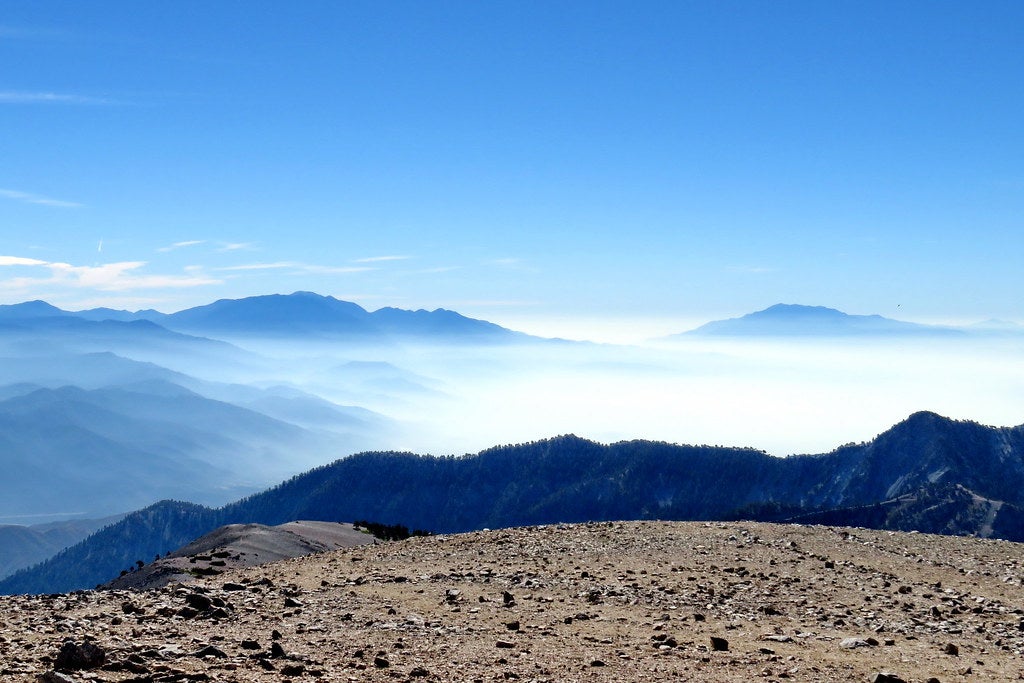
Mt. San Antonio (Mt. Baldy)
Devil’s Backbone Trail, Angeles National Forest, CA
Angelenos looking to cool off often head to the beach. Let them crowd the coast; Instead, aim for the county’s high point, 10,068-foot Mt. San Antonio, where snowfields and canyon breezes await on a 12.2-mile lollipop loop that gains nearly 4,000 feet (plan for seven hours round-trip). From the Manker Flats trailhead, 40 miles east of downtown, follow the fire trail west (passing terraced San Antonio Falls at mile .6) to a junction at mile 1. Veer southeast onto the Ski Hut Trail and trek through shrubby chaparral to the pine-dotted, granite ridgeline as you merge onto Baldy Road Trail. Continue across the exposed knife edge (3 to 7 feet wide), known as Devil’s Backbone, 3.3 miles to the summit. Take in 360-degree, mountain-to-ocean views from the treeless peak and chill in the snowfields, which persist into July most years. To return, continue looping south on the Baldy Bowl Trail to the falls, then retrace your steps to the trailhead.

ADVERTISEMENT
Ellenville Fault Ice Caves
Sam’s Point Trail, Sam’s Point Preserve, NY
Take a break from subway saunas: We’ve got a different kind of tunnel to explore. Just 90 miles north of NYC in Hudson Valley’s Sam’s Point Preserve, you’ll find the country’s largest-known exposed fault system, which means tunnels prime for summer escape. Plan about five hours to knock out a 6.3-mile out-and-back that leads past the fault zone’s crevasses to a 180-foot cascade, Verkeerderkill Falls. From the parking lot, link the Loop Road and Ice Cave Trail to the Ellenville Fault Ice Caves—usually 30°F cooler than outside and sporting year-round ice in the walls’ recesses—for a .5-mile spur loop that climbs two wooden ladders. Back on the Ice Cave Trail, connect with the Verkeerderkill Falls Trail and walk through hemlock and pine woods with blueberries and huckleberries (ripe in July and August). Check out Verkeerderkill at the turnaround at mile 3.1. Note: While you don’t need a permit, limited parking requires you arrive early (before 10:30 a.m.) on weekends.
Info Sam’s Point Preserve

ADVERTISEMENT
Sitton’s Cave
Sitton Gulch Trail, Cloudland Canyon State Park, GA
Atlanta: 90°F. Sitton’s Cave: 56°F. Venture 120 miles northwest of the city, and you’ll find Cloudland Canyon, home to this off-the-radar cave. Visit it on a 6.7-mile lasso loop that requires wading through cold, knee-deep water and mud. Set aside six hours and plan ahead: To preserve the caves, Sitton’s is only open Mondays, Thursdays, and Fridays in April, June, July, September, and October (see the full schedule at the Cloudland Canyon website). Call ahead to ensure entry, bring durable pants and a headlamp, get a free self-issue permit from the visitor center, and head out on the Sitton Gulch Trail. At mile 2.5, veer northwest (hiker’s left) onto the unmarked Sitton’s Cave Loop; enter the cave via the second entrance on your righthand side at mile 2.7. Duck below soda straw stalactites, cave bacon, and flowstone formations through the .8-mile-long underground river passageway. Expect to crawl in parts, and look out for bats, salamanders, and crayfish. Exit the cave and follow the footpath back to the Sitton Gulch Trail.