Published September 20, 2013 03:05AM
Hall Point - Change Creek Trail
Follow this fledgling trail under Deception Crags to find great views of the Snoqualmie Valley from Hall Point. Continue on to the summit of Mt. Washington.
After hearing vague talk of a new trail up Mt. Washington over the last few months, we decided it was finally time to investigate the rumors of a new approach to one of our favorite hikes. A little online research confirmed not only that the trail actually existed, but also that it was known as the Change Creek Trail and it could be found in some familiar territory: Olallie State Park and the Iron Horse Trail.
The Change Creek Trail branches off the Iron Horse Trail just above Olallie State Park near the Deception Crags climbing walls. Since being publicized in 1994, Deception Crags has become extremely popular, bringing hundreds of rock climbers to the walls every year. Like many of the other scramble routes in the area, the Change Creek Trail seems to have hacked out of the underbrush with an eye for expedience and utility without much in the way of deference to officialdom. The trail has been a work in progress since at least 2006, if not earlier. Trail building efforts have been led by someone who goes by the name of “whitebark” on various online hiking forums. We can only assume that whitebark is also responsible for the small signs posted along the trail, marking such destinations as “Whitebark’s Bivouac” and “Raven’s Roost.”
ADVERTISEMENT
The roughly hewn trail begins between the trestle bridges that span Change Creek and Hall Creek. The first mile or so is on the steep side, beneath the cliffs that attract climbers from all over the state. Loose rock and soil is the norm as you switchback up the initial sections of narrow trail. As the forest and underbrush begin to thin, glimpses of Hall Creek Falls and I-90 give a taste of views to come. Eventually you’ll attain the ridgeline, and get a peek down at Change Creek before continuing up to Hall Point for some big views of the valleys below. To the west, you can see Mt. Teneriffe and Green Mountain, that’s Mailbox and the ridgeline of Dirty Harry’s Peak to the north, and to the east there’s the beginnings of Snoqualmie Pass.
From this point the trail continues up to the top of Mt. Washington, eventually connecting up with existing logging roads – though we opted not to push past Hall Point. Instead, we enjoyed the great views and the solitude before taking some time to explore the ridge and scramble around on the exposed rock.
This is a great approach to Mt. Washington, one that we will take the next time we do the summit. Hall Point was a perfect place to settle down for a snack after slogging up the rough switchbacks of the early sections of the trail. Although still going through growing pains that should subside with more boot traffic, the trail is able to very quickly deliver big views, making it rewarding for even the most causal of hiker.
Also consider following us at: http://www.hikingwithmybrother.com


ADVERTISEMENT
Trail Facts
- Distance: 1.9
Waypoints
HP001
Location: 47.4373462, -121.6603971
ADVERTISEMENT
The trail starts by the bridge and heads up the right side of Change Creek.
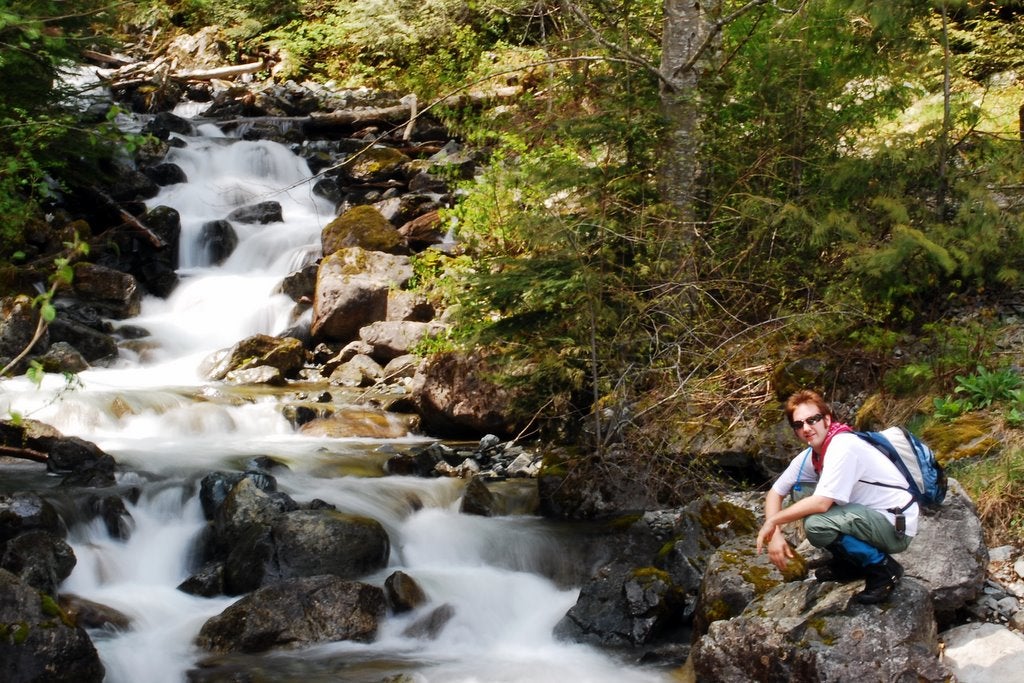
Change Creek
Location: 47.4372899, -121.6605806
Water cascading down Change Creek near the trailhead.
Old Iron
Location: 47.4369488, -121.6629088
View of the trusses on the old railroad bridge that crosses Change Creek.
HP002
Location: 47.4368662, -121.6631468
The trail comes to a T at the Iron Horse Trail. Turn left and cross Change Creek on the railroad bridge.
Deception Crags
Location: 47.4368835, -121.6633272
Climbers top-roping on Deception Crags.
HP003
Location: 47.4349603, -121.6595936
Turn right onto Change Creek Trail, before crossing the bridge over Hall Creek. The trail begins behind the chain link fence.
HP004
Location: 47.4338188, -121.6602491
Follow a short side trail to Raven’s Roost View Point.
Hall Creek Falls
Location: 47.4333492, -121.6613853
View of Hall Creek Falls in the valley below.
Whitebark’s Bivouac
Location: 47.4335379, -121.6632307
ADVERTISEMENT
Named for the trail’s creator, Whitebark’s Bivouac is a small overhang in the cliff that is an ideal place to stop for a rest in the shade.
HP005
Location: 47.4322555, -121.6646383
Intersection with a faint goat trail. Follow this trail to scramble out on to the rocky cliffs. Use extreme caution.
The Cliffs
Location: 47.4333383, -121.6642499
Out walking on the cliffs. Mailbox peak is in the distance.
Cliff End
Location: 47.4340568, -121.6631958
Looking down at Olallie State Park from the edge of the cliffs.
Change Creek Vista
Location: 47.4319013, -121.6647273
Sign marking the vista. Look south to see Mt. Washington and down into the valley to see Change Creek.
HP006
Location: 47.4302498, -121.6647583
Trail Junction. Turn left up the short path to the top of Hall Point. Continuing straight takes you to the summit of Mt. Washington in 5 miles.
Trail Marker
Location: 47.4302465, -121.6647863
HP007
Location: 47.4299584, -121.664451
Hall Point. Trail End.
Hall Point View
Location: 47.4299671, -121.6644323
View looking east toward Snoqualmie Pass.