Published September 19, 2013 09:42PM
Grand Teton National Park: Grand Traverse
Notch an epic alpine challenge on this 13-mile loop that crests 10 of the Teton's tallest peaks.
Bagging the Grand Teton is absolute life-list material. But the Grand Traverse tackles even burlier fare: It scales the Teton’s 10 highest peaks in 13 mind-blowing miles, racking up a crazy 12,700 feet of elevation gain.
Almost entirely off-trail and above-treeline, with climbing moves up to 5.8, “It might be the most consistently hair-raising three days on the planet,” says Senior Editor Shannon Davis, who’s one of fewer than 300 climbers to have completed it. (See his slideshow at backpacker.com/grandtraverse.) Guiding recommended: exumguides.com.
INFO For information on permits, current trail and camp conditions, and wilderness guidelines, go to nps.gov/grte/planyourvisit/things2know.htm.
PERMIT A wilderness permit is required for all overnight camping in the backcountry. Reservations accepted ($20 administrative fee for permits during peak season). nps.gov/grte/planyourvisit/back.htm
CONTACT Grand Teton National Park, (307) 739-3300; nps.gov/grte/
-Mapped by Shannon Davis


ADVERTISEMENT
Trail Facts
- Distance: 21.0
Waypoints
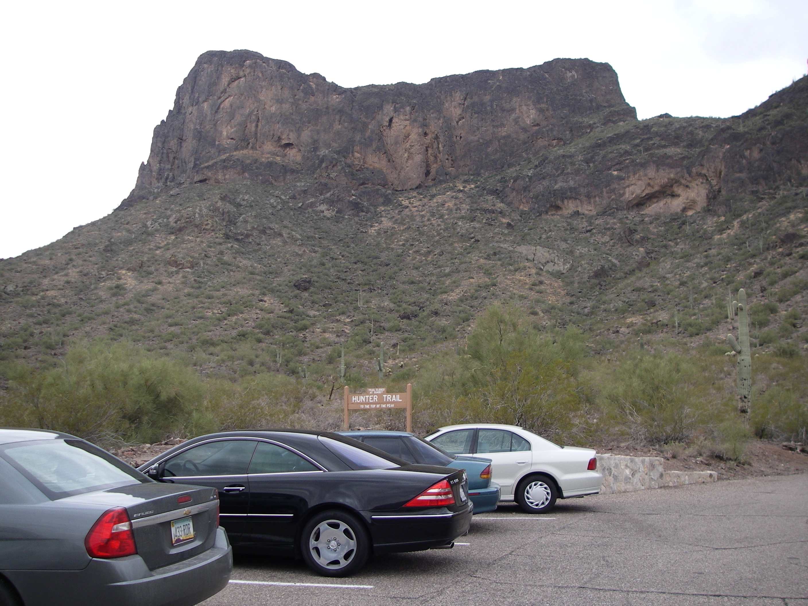
PIC001
Location: 32.642516, -111.402682
ADVERTISEMENT
Park at the Hunter Trail trailhead to ascend to the summit of Picacho Peak.
PIC002
Location: 32.640151, -111.403375
The Arizona State Parks rangers keep this trail well maintained all the way to the summit.
PIC003
Location: 32.638995, -111.403711
This ascent up steep rocks has cable hand holds. At first our mapper wondered why this was done (you don’t need the cables here). Later, he learned to appreciate the astute work done by the trail cable builders.
PIC004
Location: 32.637306, -111.404482
As you ascend up the trail you encounter a large alcove that will keep you dry in Arizona’s famous monsoon rains in the summer.
PIC005
Location: 32.63621, -111.40291
After hugging the cliff you switchback here for the final ascent to the first saddle.
PIC006
Location: 32.636476, -111.404532
Saddle: Many people stop here to admire the first views to the West of Picacho Peak. This is a popular turn around spot for the less adventurous. The route gets “Sporty” beyond this sign!
PIC007
ADVERTISEMENT
Location: 32.636249, -111.404829
Right after the saddle on the Western side of the peak you start to give up some of that elevation gain in a hurry. These cable rails are actually necessary if you don’t have technical gear or comfort with a scramble descent.
PIC008
Location: 32.634481, -111.404736
The Sunset Vista Trail steeply ascends up the Western side of Picacho Peak to meet the Hunter Trail here.
PIC009
Location: 32.634394, -111.40384
The rock climb / scramble is “secured” by a cable and fence on the right (ya right!). I would recommend that you get good hand holds and not ask the fence to arrest your fall!
PIC010
Location: 32.634774, -111.403426
This crack system is the vertical route to the next level on the mountain. There’s one class 4 spot where you have to clear a small choke stone that the cable becomes a necessity.
PIC011
Location: 32.635082, -111.403011
ADVERTISEMENT
Before turning the corner for the final ascent to the summit you must first cross this bridge built on a small rock bench with serious exposure.
PIC012
Location: 32.635018, -111.400549
summit
Trailhead Parking
Location: 32.642444, -111.402607
Well Maintained Trail
Location: 32.640169, -111.403386
First Cable Ascent
Location: 32.639004, -111.403722
More cables
Location: 32.638217, -111.404348
Easterly Views
Location: 32.637315, -111.404493
As you ascend up the trail the views to the East open up. Notice how close Interstate 10 is. You can see Neuman Peak on the other side of the Freeway and the trailhead is visible below by the cars parking at the end of the loop road.
Trailside cave
Location: 32.637306, -111.404503
Author Photo
Location: 32.63621, -111.402889
It was a cool Arizona morning in the 40’s.
Saddle Overlook
Location: 32.636484, -111.404553
Steep Descent
Location: 32.636249, -111.40484
Wow – I came down that?
Location: 32.635598, -111.405178
Looking back up the Western descent route makes you wonder how those with less experience routinely do this!
Trail Junction
Location: 32.634472, -111.404789
Wow, this gets interesting!
Location: 32.634438, -111.404256
ADVERTISEMENT
Notice the people on the steep ascent up the rock ramp. If you look very closely you’ll see cables going up the vertical cliff face at the end of the ramp!
More Rock Climbing
Location: 32.634376, -111.403819
Around the nose from the “fence” is another scramble guarded by cables.
I’m going up that?
Location: 32.63443, -111.403744
Vertical Chute
Location: 32.634747, -111.403426
This crack system is the vertical route to the next level on the mountain. There’s one class 4 spot where you have to clear a small choke stone that the cable becomes a necessity.
A SKY BRIDGE?
Location: 32.635109, -111.403012
Holly cow Batman, now what? Before turning the corner for the final ascent to the summit you must first cross this bridge built on a small rock bench with serious exposure.
Sky Bridge during cross
Location: 32.635117, -111.403278
Sky Bridge Close-up
Location: 32.635172, -111.403278
After crossing the sky bridge I snapped this photo looking back as confirmation that I made it.
Hikers Descending
Location: 32.635144, -111.403289
ADVERTISEMENT
Some class 3 scrambling on the descent. These hikers are not even to the vertical crack cable yet.
Peak Bagger Pose
Location: 32.635135, -111.400698
That’s me (Rich) with my summit pose.
Summit View – Southeast
Location: 32.635081, -111.40057
Toward Tucson
Summit View – West
Location: 32.635108, -111.40057
Summit View – East
Location: 32.635144, -111.40057
Summit View – North
Location: 32.635135, -111.400592