Published September 16, 2020 03:55PM
Basecamp Weekend: Grand Island, MI
Spend a weekend on the water on this circumnavigation of a lonely island in Lake Superior.
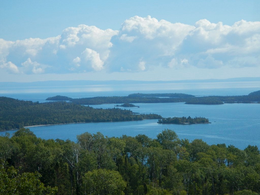
Rim Trail, Grand Island National Recreation Area, Michigan: I wake up, unzip my tent, and walk down a short trail to the edge of the world. To the north stretches the vast expanse of Lake Superior, no land in sight; From my campsite atop a wave-cut sandstone cliff I watch sunrise paint watercolors in oranges and yellows across the glassy water. I’m only halfway around the island, but if I didn’t need to be back at the ferry dock by the next morning, I would be tempted to stay in this moment of solitude forever. Instead, I linger for a few more moments before turning away to pack up camp. After all, a quiet day of trekking through the dense forests and wildflower-spotted underbrush of this island is nothing to complain about. By Amanda Hermans
Turn-by-Turn from the Ferry Dock
1. The Rim Trail begins about 100 yards past the ferry dock and welcome center, heading east. The first mile is a bit swampy (bring your bug spray), but the late summer wildflowers, including asters and goldenrods, make up for any bites.
2. At mile 3, follow signs to stay straight (north) as the Rim Trail briefly joins with a wider dirt road. Mile markers continue along the road.
3. At mile 4, take the 0.6-mile spur northeast to a lunch spot at Echo Lake. After checking out the numerous beaver dams and grabbing some lunch, head back to the main trail.
4. At mile 5.2 leave the road and continue north behind the Mather-Klauer lodge, once a retreat for the island’s past owner.
5. Reach your first campsite, Preservation Point, at mile 8.8.
ADVERTISEMENT
6. The next morning, continue past several Lake Superior viewpoints between the trees on your left.
7. At mile 10.8 the trail turns south, entering dense beech forests for 7 miles.
8. Find your second campsite at mile 17.8, about a quarter mile down a fine white sand beach. The Trout Bay bus stop is nearby, but the site is well away from the dirt road, which is closed to all traffic except park staff and bus tours.
9. In the morning, complete your circle by curving south past Duck Lake. On the 3-mile trek back to the ferry dock, you’ll pass an old graveyard, a quarry, and a cabin with interpretive signs showcasing the history of the island’s past residents.
Campsite 1: Preservation Point Campsite (mile 8.8)
Here’s your chance to live on the edge: Three hundred feet up on a red and orange painted sandstone cliff, this site offers uninterrupted views north across Lake Superior, and an ideal spot to take in the sunset over dinner. Pack water or gather it earlier in the day—you may be able to see the lake from this site, but you sure can’t get to it. The tent pad, which has room for two tents, lies about 15 yards away from the cliff’s edge and is protected from the lakeside breezes by a thin screen of trees. The site includes a fire ring, bear pole and backcountry latrine.
ADVERTISEMENT
Campsite 2: Driftwood Campsite (mile 17.8)
The promise of a secluded sand beach makes this site an easy choice. Nestled into a dune-covered tombolo, the Trout Bay beach offers a winning combination of water access, towering red and white pines, and views across the lake to Pictured Rocks National Lakeshore. The site includes a fire ring, bear box and pole, and a backcountry toilet. You can’t gather firewood in the tombolo’s sensitive ecosystem, but park staff drop firewood daily at the Trout Bay bus stop for camper use (shared with the nearby Little Duck site).
Tombolo
The unique—and sandy—topography of the southeast corner of Grand Island is the result of a hundred years-long science experiment. Wave movement and sediment buildup slowly formed a tombolo, a stretch of land connecting two formerly separate islands. The vegetation here is sensitive (make sure to stay on marked trails and campsites), but the grassy dunes and wildflower-covered swales offer a welcome contrast to the dense forests that cover the rest of the island.
ADVERTISEMENT
Trip Planner
Trailhead: West Rim Trail (46.453228, -86.672652) begins about 100 yards north of the Grand Island ferry docks.
Season: Memorial Day weekend – Mid-October (when the ferry stops running)
Permit: Ferry tickets ($20 for adults) include the forest use fee. Reservations ($8-10/night) are required for campsites.
Info: fs.usda.gov/hiawatha
Distance: 22 miles
Time: 3 days
Difficulty: 2/5