Published September 19, 2013 11:09PM
Grand Canyon National Park: Skeleton Point
Get full-canyon views from Skeleton Point on this 7-mile drop into the Big Ditch.
This 7-mile route starts at South Kaibab Trailhead on the Grand Canyon’s South Rim and immediately descends to Skeleton Point for breathtaking views of the surrounding canyons and the sounds of the Colorado River. Go just a bit further down, ancan see Natural Arch at the top of the butte.
PLAN IT
GUIDEBOOK AND MAP Hiking Grand Canyon National Park, 3rd Edition, Ron Adkison and Ben Adkison ($19, falcon.com). Trails Illustrated Grand Canyon ($12, natgeomaps.com). Plan other trips in the park using BACKPACKER’s Grand Canyon National Park page.
CUSTOM TOPO MAPS Download tracks and waypoints, print or order custom topos, from the map tools menu on the web version of the trip report.
SEASON March to May and October to November. From June to September, inner canyon temps from are often above 100°F. Start early to beat the midday heat. Also, don’t forget it is much easier to descend into the canyon than climb back up. Expect to spend at least double the time climbing than descending
KEY GEAR Wide-brim hat and six liters of water storage.
PERMITS $10 per permit, plus $5/person per night. Apply for a permit on the first of the month four months prior to your hike date (e.g., June 1 for a hike beginning in Nov.) and fax it to (928) 638-2125
CONTACT Backcountry Information Office: (928) 638-7875 (from 1 to 5 p.m., Monday to Thursday), nps.gov/grca
STOCKUP Canyon Village Marketplace, South Rim. (928) 638-2262 http://www.nps.gov/grca/index.htm
FREE TRIP PLANNERS Get news on vacation deals and lodging at mygrandcanyonpark.com
ADVERTISEMENT
10 Summer Hiking Essentials
Water – Plain and some with electrolyte replacement.
Food – especially salty foods. Eat twice as much as normal.
First Aid Kit – bandaids, ace wrap, antiseptic, moleskin, etc.
Map – while many trails are well-marked, maps are helpful tools.
Pack – to carry the essentials.
Flashlight/Spare Batteries – allows you to hike out during the cool of the evening.
Spray Bottle – fill with water for your own personal air conditioning system.
Hat/Sunscreen – to keep the sun off you and protect your skin.
Whistle and/or Signal Mirror – for emergency use.
Waterproof Clothing – poncho or jacket; especially usefull during monsoon season (mid-July to early September).
The South Rim: Open All Year
ADVERTISEMENT
The South Rim is open 24 hours a day, 365 days a year. All visitor services: camping, lodging, and restaurants are available year round.Reservations are strongly recommended during the busy summer season. Some facilities are closed during the winter. A free shuttle bus system operates in the Grand Canyon Village area. Make your visit easier by parking your car at the Visitor Center and using the free shuttle buses to get around the village.
Market Plaza is the Business Center of the Village. Here you will find a general store and deli, a bank, post office, and cafeteria at Yavapai Lodge. Market Plaza has a large parking lot (B) and is in a central location. It is a good place to park and access the park’s free shuttle system.


Trail Facts
- Distance: 10.6
Waypoints
YSP001
Location: 36.05341, -112.08355
Head north from the South Kaibab Trailhead (port-a-potties are available here). From May to mid-October, fill water bottles at the spigot near the bus stop. Caution: There are no other water sources along the South Kaibab Trail.
YSP002
Location: 36.06147, -112.087067
ADVERTISEMENT
Pass the first viewpoint, which reveals views of countless buttes to the east. If possible, time this stretch with the sunrise. Next, the trail snakes down the canyon on a multitude of switchbacks (supported by metal rebar and pipes). The switchbacks and well-maintained, paved trail make this potentially steep descent less difficult. As you descend, you’ll get an up-close view of the canyon’s various layers.
YSP003
Location: 36.064053, -112.089485
Head north along Cedar Ridge, a wide ridge that resembles a plateau (stunning bird’s-eye views of the canyon). There are established composting toilets here.
YSP004
Location: 36.07172, -112.088699
As the trail winds to the east behind O’Neill Butte, you’ll catch more views of the canyon below.
YSP005
Location: 36.081291, -112.089996
Pass Skeleton Point, which offers the first views and sounds of the Colorado River. Look down to the east to see the numerous switchbacks ahead.
YSP006
Location: 36.085461, -112.086372
Look up towards the north-northwest and you can see Natural Arch at the top of the butte.
South Kaibab Trail
Location: 36.058781, -112.085053
Descending the South Rim via switchbacks on the South Kaibab Trail. ©Trung Q. Le
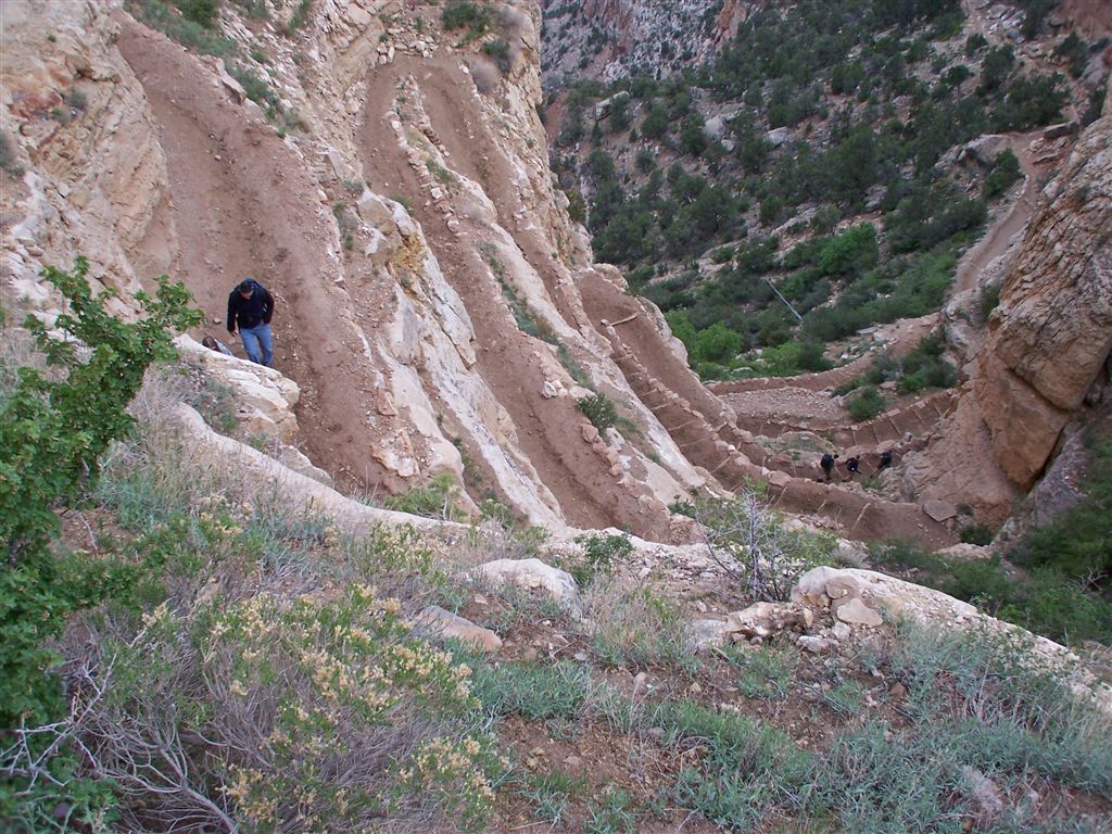
View from Skeleton Point
Location: 36.081257, -112.090073
The switchbacks from Skeleton Point to the canyon floor. ©Trung Q. Le © Darrin Funk.jpeg
O’Neill Butte
Location: 36.060548, -112.086296
ADVERTISEMENT
Trail leading down to Cedar Ridge and O’Neill Butte. ©Trung Q. Le © Darrin Funk.jpeg
Views from Cedar Ridge
Location: 36.06596, -112.090373
Views to the east from Cedar Ridge. ©Trung Q. Le © Darrin Funk.jpeg
Natural Arch
Location: 36.085384, -112.086296
©Trung Q. Le © Darrin Funk.jpeg