Published July 8, 2016 09:25PM
Hiking the Highest Point on the Pacific Crest Trail
Our PCT correspondent goes up Forester Pass—and takes the easy way down.
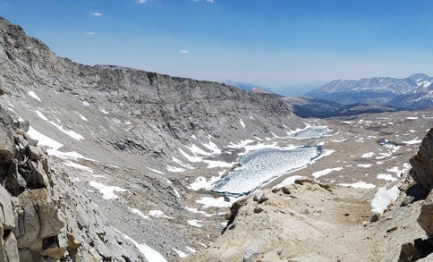
'Looking down into the valley from towering Forester Pass. Photo by: Amanda Jameson'
One of the more fun parts about this trek is the feeling of half-knowing what’s coming up: knowing what the elevation and terrain is like from the maps, hearing stories about the conditions from other hikers, but not quite knowing what it’ll actually be like to walk the trail. So after a full night’s sleep after Mount Whitney, we planned to hike just 9 miles to the approach to Forester Pass, the tallest and most notorious point on the PCT, and then see how we felt, what it was like, and whether or not we wanted to continue on from there.
There’s very little snow in this part of the Sierra this year. Normally, people average about 15 miles a day in this section, though not for want of higher mileage. Between the elevation change and the snow—ice in the morning, fragile and prone to postholing in the afternoons and evenings—it’s just hard to do much more. This year, folks have been averaging in the 20-mile range. There’s snow, but it’s hardly an impediment to making miles. So we were hopeful, if still unsure.
Such was the case at Forester Pass. We got the trail family together for safety, but only crossed a couple of snow fields to get to the approach, and the only snow on the south side was the infamous ice chute near the top—just 10 yards of snow so well-worn we barely needed microspikes to cross. On the north side, there was a lot more snow, but the afternoon made it prime for glissading.
The north side of Forester Pass also looks down into Kings Canyon, and as we descended, every bend in the trail held more beauty (and more water, a welcome change from the desert). After creek crossings and elevation loss aplenty, we made it to Vidette Meadows, 21 miles from our camp yesterday, where the Vidette Trail Angels had brought four mules’ worth of food—welcome trail magic for our tired crew. Every day is a new adventure, and only half-knowing what’s coming is half the fun.