Published September 20, 2013 03:31PM
Glacier National Park: Iceberg Lake
Can't afford a full week in Glacier? Try this daylong sampler, a 5.2-mile hike that passes waterfalls and jagged peaks, climbing to an alpine lake pinched in by 3,000-foot walls.
Winding from a frontcountry campground area to Iceberg Lake, this 9.2-mile out-and-back in Many Glacier is a moderate day hike with a spectacularly scenic payoff: an iceberg-laden lake perched just below the Continental Divide.
From the trailhead on the northwest side of the camping cabin parking area, the trail climbs steeply for the first 0.3 miles and then levels out for a westbound traverse below the ridge linking Mount Henkel and Crowfeet Mountain—look for mountain goats on the alpine meadows to the north. On a gently graded climb, the trail crosses several small creeks and alternates between open pine and spruce forests and weeping, dripping walls en route to Ptarmigan Falls at mile 2.4. You’ll bypass the Ptarmigan Tunnel Trail and round the top of the Iceberg Creek drainage as the trail approaches treeline and climbs past an unnamed tern lake just before a quick descent to Iceberg Lake’s eastern shoreline. The rocky beach is a great place for a snack before backtracking to the trailhead.
The entire climb up the valley’s north side, you’ll have great views of Grinell Point, Mount Grinell, Mount Wilbur, and a snow-filled couilor—Iceberg Notch—the entire climb. For more details about Glacier’s extensive trails, check out their website: nps.gov/glac.
-Mapped by Kristy Holland


Trail Facts
- Distance: 15.0
Waypoints
IBL001
Location: 48.799514, -113.679099
The trail starts on the northwest side of the large parking area near cabins and the camp store. Follow signs uphill toward Iceberg Lake, bypassing the trail to the Many Glacier Hotel.
IBL002
Location: 48.802607, -113.680002
After a 250-foot climb, turn left at this signed T-junction just 0.2 miles from the trailhead. The climbing mellows from this point, but you’ll continue gently uphill another 1,000 feet over the next 4.3 miles.
IBL003
Location: 48.806911, -113.687897
As the trail levels out, look around for breathtaking snowy-mountain views. Before the trail tucks behind Mount Wilbur, look left toward the glaciers flanking Swiftcurrent Mountain.
IBL004
Location: 48.810055, -113.696404
ADVERTISEMENT
As the terrain alternates between open forest and alpine meadow, you’ll cruise prime territory for bears, and below prime territory for mountain goats and big horn sheep. Keep a sharp eye out for the sure-footed mammals and make plenty of noise on the trail to avoid surprising a black bear or grizzly. Mt. Wilbur (9.321 ft.) looms on the left.
IBL005
Location: 48.811188, -113.702402
Exposed sections of the greenish-grey rock lining the trail weep with water in the spring and early summer and foster dozens of species of wildflower. Look for an abundance of wild rose, avalanche lily, shooting star, and Indian Paintbrush when there is moisture along the trail.
IBL006
Location: 48.821442, -113.711403
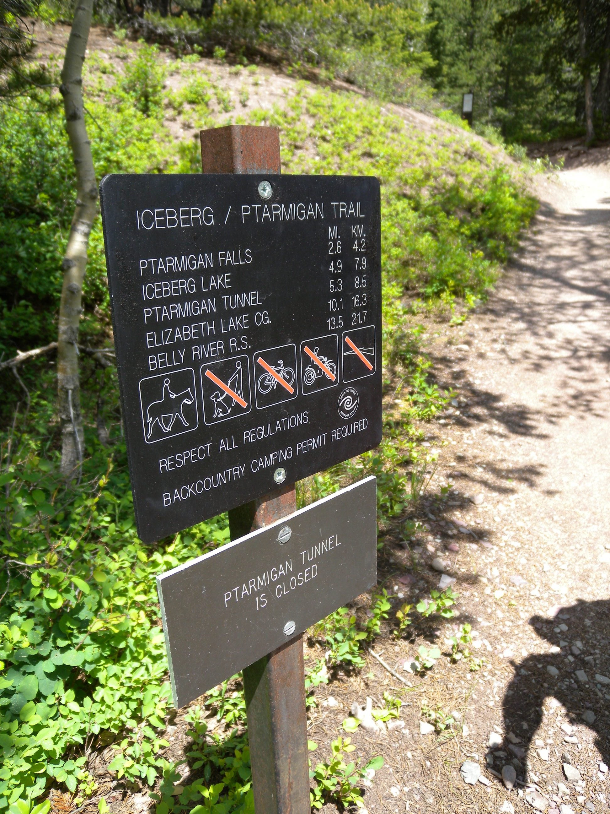
Stop for a break and photo opp at Ptarmigan Falls near mile 2.4. The trail crosses a bridge at the head of the falls and continues along the valley’s northern slope. You’ll bypass the Ptarmigan Tunnel Trail just after the bridge.
IBL007
Location: 48.827412, -113.721916
The trail approaches treeline and follows the curve of the headwall west below the sheer rugged ridgeline. Look for Iceberg Notch looming above the lake up ahead.
IBL008
Location: 48.825514, -113.732057
ADVERTISEMENT
Hike the midline of Ptarmigan Wall, a giant gray rock face that skyrockets 2,000 ft. above the trail. It gets rockier from this point on and you might encounter snow on the trail even into the summer.
IBL009
Location: 48.82008, -113.741142
Approaching the lake, look for bighorn sheep negotiating the steep cliffs; the glacial cirque closes in as you finish the last bit of climbing and cross a small creek up ahead.
IBL010
Location: 48.81612, -113.74305
Frozen chunks float in Iceberg Lake and the rocky shoreline offers excellent seats for picnicking and enjoying the dramatic cirque view before backtracking to the trailhead.
Trailhead
Location: 48.800183, -113.67922
The trail is well-marked and easy to find, just follow signs toward Iceberg Lake.
Water
Location: 48.803778, -113.681779
The steep wall above the trail is criss-crossed with streams and melt water drainages.
Ptarmigan Falls
Location: 48.821163, -113.712015
You’ll pass above this boisterous falls along the Iceberg Lake trail.
Bridge
Location: 48.821527, -113.712036
Crossing Ptarmigan Creek just above the same-name falls.
Hiking
Location: 48.807162, -113.689531
Stone walls and lush vegetation along the trail.
Mount Wilbur
Location: 48.827087, -113.726092
ADVERTISEMENT
The trail tracing the headwall and heading west toward Iceberg Lake.
Snow
Location: 48.819077, -113.740703
Expect cooler temperatures near the lake. This image (from early June) demonstrates the potential for snow even well into the summer.
Snow
Location: 48.818394, -113.740738
Return Trip
Location: 48.809098, -113.694698
Views on the return trip–of Wynn and Allen mountains in the distance–are equally breathtaking.