Updated August 1, 2025 07:17AM
This Hard-to-Reach Mountaintop Lookout Is the Coolest Place I've Ever Slept
On the formidable hike to Washington's Three Fingers Lookout, both risk and reward abound.
(Photo: Connor Boschert)
As I scrolled through trip reports on the eve of our hike to the Three Fingers Lookout, I started getting jittery. Phrases like “very steep” and “high exposure” made my stomach sink.
In the Washington Trails Association’s hike description, I studied the crux of the route: “If you slip a best-case scenario is to slide about 200 feet into rocks. A worst case scenario is to miss the rocks and continue down several thousand feet to the crevasses at the bottom of the glacier.”
And the one that made me stop in my tracks: “A fall here would be fatal,” read one report from a month prior.
Logically, I knew that the conditions on the route had changed drastically since that comment was posted. From studying satellite imagery, I knew that the snow and ice that particular party had encountered high on the summit had since melted out, and that where they’d built anchors and ascended with ropes, I’d be able to climb dry fixed ladders. I also knew that with crampons, an ice axe, and some mountaineering experience under my belt, I was more than prepared for the snow crossings and ridge traverses. Still, I was nervous.
ADVERTISEMENT
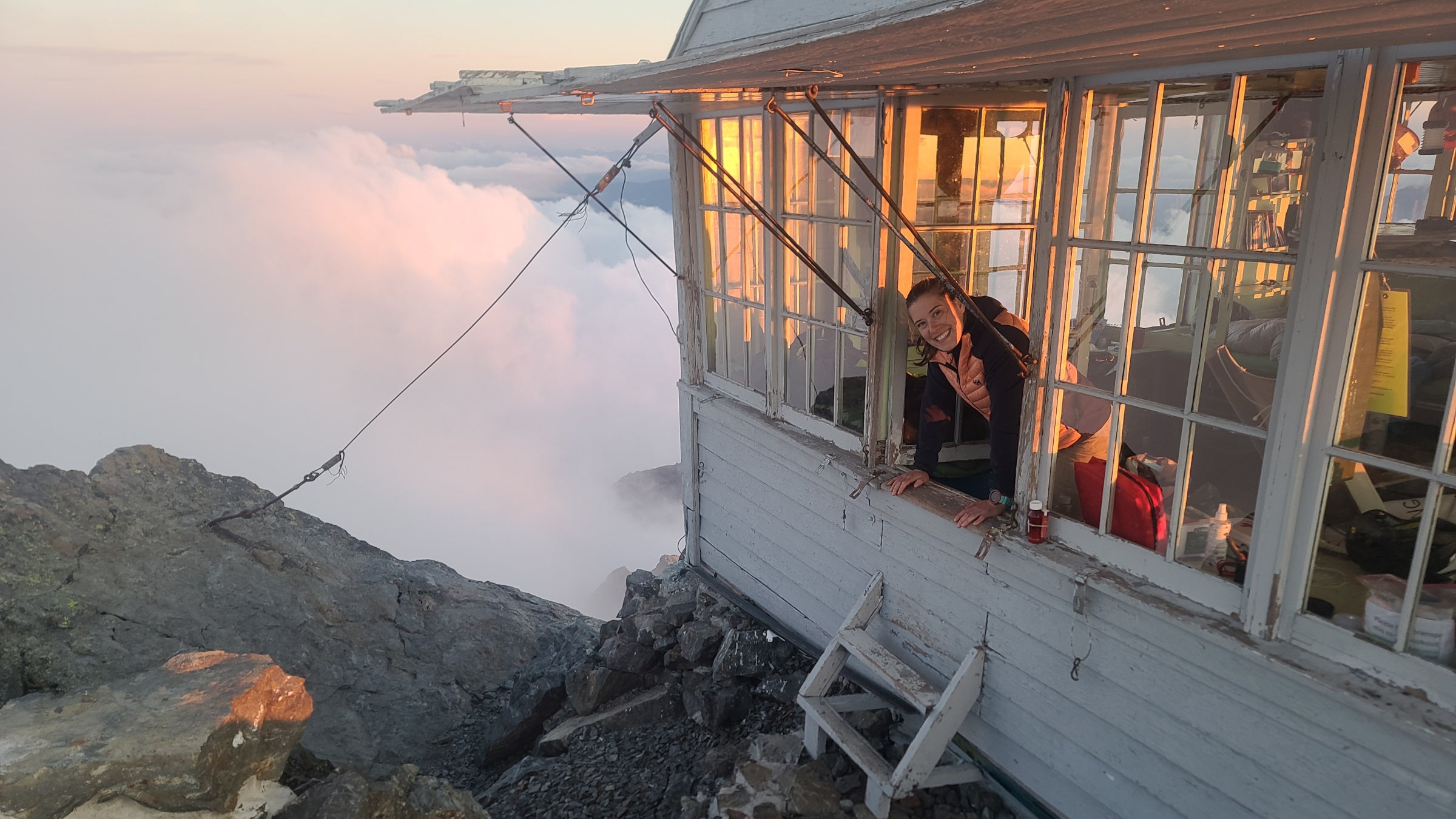
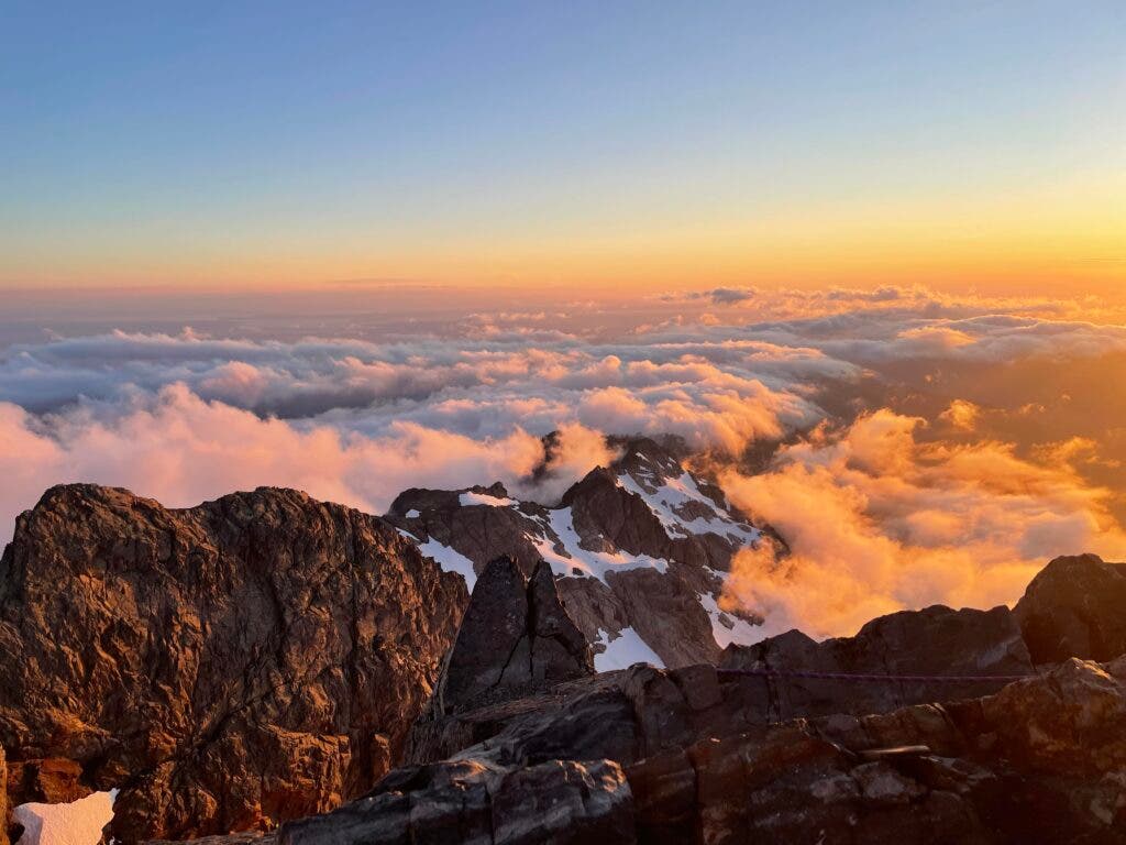
More than 10 years ago, my partner, Connor, read about Washington’s Three Fingers Lookout in an issue of Backpacker. The historic structure, which was built in the early 1930s to spot forest fires, sits atop a narrow summit in the Boulder River Wilderness of the North Cascades. The lookout has been out of commission since the ‘40s, but is maintained by volunteers and open to overnighters all summer. With dramatic 360-degree views of Mt. Rainer, Mt. Baker, and the Puget Sound, plus an adventurous hike to get there, Three Fingers is a bucket list destination for scores of backpackers.
So it was for Connor. He’s been talking about the hike to Three Fingers for years, even more often since we moved to Washington three years ago. So for his birthday in mid-July, we decided to finally make it happen. Connor’s an accomplished mountain climber, and a member of the local search and rescue team. I’m a seasoned hiker and backpacker, and I’ve spent the last few years building up my experience with snow travel and route-finding. But when it comes to taking on challenges in the mountains, I’m still working on my confidence.
On top of that, Three Fingers has been the scene for scores of search and rescue missions over the years. A rise in popularity, likely in part thanks to social media, certainly factors in. In 2023, three hikers ill-equipped for an overnight set off a 32-hour multiagency rescue. In the fall of 2021, foul weather near the lookout caused various hikers to call in professional help. Just a few months prior to that incident, two hikers spent a night on a ledge before calling SAR. The list goes on and on.
So, despite being well-prepared with gear and knowledge of the route and current conditions, I was nervous as I swung my pack over my shoulders and climbed onto my mountain bike for the 8-mile approach to the trailhead. The first challenge hikers to Three Fingers face is a road washout that adds significant distance to the journey. (On our exit the following day, I saw hikers walking all manner of city bikes over the overgrown road, which nowadays resembles a singletrack gravel trail. A full-suspension mountain bike is highly recommended. If you’re not comfortable on a bike, factor in 16 extra miles of walking.)
ADVERTISEMENT
I mountain bike most days in the summer, but riding with a 27-pound pack proved difficult. Still, Connor and I crushed the bike ride, reaching the trailhead more than an hour ahead of schedule. My confidence was beginning to rise, but I knew the biggest challenges awaited above treeline.
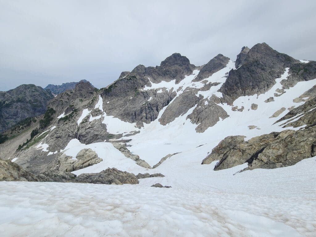
We settled into a groove as we hiked over blowdowns and through overgrown brush, which Connor happily hacked at with a machete left by volunteers at the trailhead. At treeline, we caught our first glimpse of the lookout, a tiny square speck perched impossibly on a triangular peak in the distance. We agreed that if any of the snow crossings or the ridge traverse between us and the summit felt unsafe, we would turn around and camp in an open meadow below the ridge.
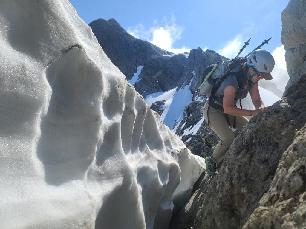
Soon enough, we reached the crux section. Connor and I stopped for a snack and to discuss our strategy. We scoped a moat between the mountainside and the glacier near Tin Can Gap, which later in the summer allows hikers to avoid the steepest snow crossing. Today, we decided, we’d have to traverse the snow. Glancing at the long and steep runout caused my heart rate to spike, but we were prepared. I donned my crampons and took some deep breaths.
ADVERTISEMENT
I plunged my ice axe with each step, my relief growing as I realized that my gear and hours of practice on snow were paying off. The subsequent crossings only got easier.
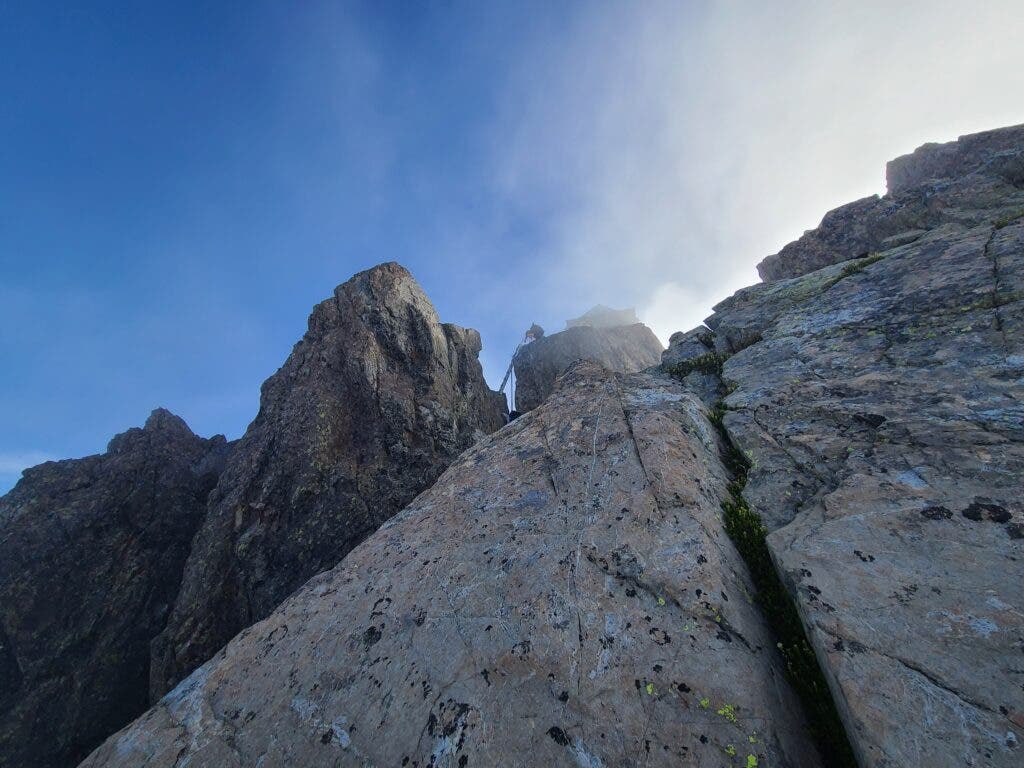
I’d been irrationally concerned about the three vertical wooden ladders that guard the final climb to the Three Fingers Lookout. I’d read that they were secure but exposed. I was once an avid rock climber—some wooden ladders should be a walk in the park. But the idea of exposure with a full pack got in my head. By the time we reached the ladders, though, I felt strong. We were still hours ahead of schedule. We’d traversed the most technical part of the route without issue. A part of me had been sure—hoped, even—that we’d be setting up camp in the meadow down below by now. But we’d cruised over every bit of terrain I’d read about with anxiety the night before. Some ladders were not going to stop me.
A few hours after settling into the lookout, Connor and I enjoyed one of the most dramatic sunsets I’ve ever seen. I was elated; we’d arrived with hours of daylight and energy to spare. I’d been mentally prepared for a sufferfest; instead, the ascent had been the perfect challenge level. I’d faced some discomfort in a safe way and proven to myself that I was capable, all while having the presence of mind to enjoy the spectacular alpine surroundings. A night spent above the clouds was the cherry on top.
ADVERTISEMENT
As we hiked out the following day, I felt empowered. The snow crossings felt even more approachable the second time around. Soon enough, every technical bit was behind us, and we were back in my comfort zone on singletrack.
Now it was Saturday, and we passed far more hikers than we’d seen the previous day. As we greeted each person ascending, I couldn’t help but notice that many of them seemed woefully underprepared. A few carried crampons and ice axes like us, and one group even had pickets and ropes. But others didn’t appear to have any traction, or even a solid understanding of the route. Below treeline, one pair with standard backpacking kits asked us if we’d encountered any snow up high. Connor and I shared a glance. Had they done any research?
As we walked out to the trailhead, I thought back to all of the search and rescue missions I’d read about. The Three Fingers Lookout has become wildly popular over the years, and it seemed to me that many hikers falsely conflate that popularity with approachability. Plenty of people make it up there every summer, but that doesn’t mean it’s easy, or without risk. I’d landed on the other end of the spectrum—needlessly scared for an objective that was well within my abilities.
ADVERTISEMENT
Surely there’s an ideal balance somewhere in the middle, and it comes down to doing your research and knowing your own limits and ability level before hitting the trail. When venturing beyond basic trail walking, hikers need to know how to evaluate terrain, to study maps and imagery and trip reports ahead of time, to curate a gear list that matches the objective, to have backup plans, and to make in-the-moment decisions with safety in mind. Apps and social media can lend inspiration—but they’re no substitute for detailed, up-to-date information about a trail and experience.
Next time I test myself on a challenging trail, I’ll be sure to do my research. I’ll study the route, I’ll check the weather, and I’ll carefully choose my gear. But I’ll also do my best to leave my fear behind. A little bit of confidence goes a long way.
Hike It
Miles: 31 round-trip, out-and-back (16 are bikeable)
Elevation: 4,200 feet
Sleeping space in the lookout is first-come, first-serve. The structure can fit 6 to 8 people; be prepared to get cozy with strangers. Arrive early, especially on summer weekends, and carry a tent as backup. There is nowhere to camp in the vicinity of the lookout; be prepared to hike back to Goat Flats, 2,000 feet below the lookout, if the structure is full.