Published February 18, 2010 04:32PM
Editors' Choice 2010: Switzerland Photo Slideshows
View stunning vistas and snowy passes in these photos of Switzerland's Via Alpina route. Included: the Eiger, the Wetterhorn, and Jungfrau Glacier.
'switzerland via alpina'
Adelboden to Kandersteg
Get ready for a ten-mile day, 4,265 feet of elevation gain, and the Bunderchrinde, the third highest pass on the Via Alpina.
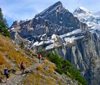
Kandersteg to Griesalp
The Editors’ Choice testing crew tackles the highest passes in the Swiss Alps.
Griesalp to Lauterbrunnen
The Editors’ Choice testing crew finishes their final day under the base of the mighty Eiger.
Altdorf to Engelberg
Starting in the town of Altdorf, the Editors’ Choice team gains over 6,000 feet of elevation gain in 17 miles on its way to Surenenpass.
Engelberg to Meiringen
Hike from Trubsee lake and Jochpass and down to Engstlensee lake for stunning views of the Wettehorn.
Climbing the Monch
After 100 miles hiking in the Swiss Alps, the Backpacker editors couldn’t resist a summit of one of Europe’s most famous peaks, the Monch.
The Eiger and Jungfrau Glacier
The Eiger is made up of the stuff of legend. Here, an up close and personal look at the moutain.