Published September 19, 2013 11:24PM
Eagle Cap Wilderness Loop
Eagle Cap's top trip, a 41-mile tucked away in the southeastern part of Oregon's largest wilderness, deals a royal flush of granite towers and secluded lakeside camping.
Eagle Cap Wilderness Loop
From East Eagle trailhead, follow Trail 1910 toward Horton Pass; seven miles in, just before climbing the pass, take the unmarked trail 1.8 miles to Hidden Lake, and camp on its lonely shores ringed by spiky peaks. From Horton Pass on day two, make the 90-minute round-trip up trailed 9,572-foot Eagle Cap for its 360-degree vista of the range. Continue on Trail 1910 to descend into the Lakes Basin and pick up Trails 1806 and 1820 to sweeping views of the wilderness from Glacier Pass and Hawkins Pass. Complete the loop via Trail 1816, Cliff Creek Trail 1885 (where the larch foliage pops in early October, as it does along Eagle Creek), and Trail 1945.
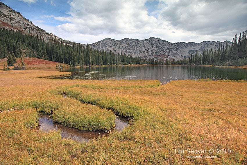
The wildflowers, lake panoramas, and fall colors make this loop a photographer’s dream. Save space on your memory card for: Mirror Lake reflecting Eagle Cap Peak; Glacier Lake laced by rocky peaks cloaked in snow; and the view down the South Fork Imnaha River Valley from Hawkins Pass. Hit the lakes in the early morning for calm, reflective waters. To see blooming Indian paintbrush, sego lilies, bluebell, and other wildflowers (best at Hawkins Pass and along Cliff Creek), go in July.


Trail Facts
- Distance: 68.5
Waypoints
New East Eagle Trailhead
ADVERTISEMENT
Location: 45.047882, -117.327578
Little Kettle Creek Junction TR 1945
Location: 45.055382, -117.321151
Road Crossing
Location: 45.057015, -117.32275
View Up Valley
Location: 45.093336, -117.299215
Meadows
Location: 45.100423, -117.298184
A Stream
Location: 45.111212, -117.296208
Cairn Marks Hidden Lake Junction
Location: 45.138879, -117.302395
Moon Lake
Location: 45.137744, -117.320594
Rocky Trench
Location: 45.139333, -117.322543
Nice Campsites
Location: 45.139987, -117.326207
Small Pond
Location: 45.138643, -117.328979
Downed Trees
Location: 45.140758, -117.328963
Meadows at Hidden Lake
Location: 45.141065, -117.331023
Eagle Cap and Glacier Peak Reflected in Hidden Lake
Location: 45.141263, -117.330193
The solitude found at the vast meadows at the West end of Hidden Lake are worth the side trip. The camping possibilities are vast.
Large Stream
Location: 45.141605, -117.305063
Junction – Sharp Right!
Location: 45.146935, -117.310634
Wooden Post in Cairn
Location: 45.147318, -117.310103
Stream At Switchbacks
Location: 45.160099, -117.319089
Approaching Horton Pass
Location: 45.160949, -117.317441
That Stream Again
Location: 45.164977, -117.319577
Talus Gully
Location: 45.16794, -117.322349
ADVERTISEMENT
The Pink Passageway
Location: 45.17004, -117.321105
Big Grey Blocks
Location: 45.169794, -117.318501
Slot In Trees
Location: 45.170038, -117.317647
Horton Pass
Location: 45.170081, -117.316459
Direct Trail To Summit at Ridgeline
Location: 45.170046, -117.316491
Junction of Official and Ridge Direct Trails
Location: 45.168473, -117.314203
Summit Shrubbery
Location: 45.163262, -117.302615
15-SEP-10 4:35:28PM
Eagle Cap Summit
Location: 45.163631, -117.301707
15-SEP-10 4:37:29PM
Eagle Cap Summit Panorama
Location: 45.163684, -117.301575
Glacier Lake From Eagle Cap Summit
Location: 45.163646, -117.301573
Looking East from the summit of Eagle Cap, over Glacier Lake. Polaris Pass and Sentinel Peak are in the distance.
Official Summit Spur Trail
Location: 45.171883, -117.313774
Eagle Cap Summit Spur
Location: 45.171946, -117.313786
East Lostine/Horton Pass Junction
Location: 45.179355, -117.315265
Mirror Lake Campsites
Location: 45.179618, -117.311368
Junction
Location: 45.180358, -117.308812
Moccasin Lake Jct
Location: 45.182163, -117.301654
Glacier Pass
Location: 45.167563, -117.284848
Eagle Cap From Glacier Lake
Location: 45.163417, -117.284276
ADVERTISEMENT
The sunlit summit of Eagle Cap, reflected in the chilly green waters of Glacier Lake.
Glacier Lake
Location: 45.163215, -117.284291
Glacier Peak From Glacier Lake
Location: 45.163357, -117.284184
Glacier Peak and Lake
Location: 45.163306, -117.284149
Hawkins Pass Junction 2
Location: 45.154962, -117.257475
Little Frazier Lake
Location: 45.152415, -117.266135
Little Frazier Lake
Location: 45.149162, -117.270727
Hawkins Pass
Location: 45.145741, -117.267441
Jackson Peak and South Imnaha River From Hawkins Pass
Location: 45.145363, -117.266779
Channel Your Inner Goat
Location: 45.14385, -117.265038
Another Nice Waterfall
Location: 45.135696, -117.270398
Stream Crossing
Location: 45.134218, -117.270972
Rocky Flats
Location: 45.11939, -117.249286
Hawkins Pass Junction
Location: 45.107992, -117.227354
Easy Ford South Imnaha
Location: 45.107791, -117.227147
Lower and Upper South Fork Junction
Location: 45.103042, -117.229309
Thighscraper Avenue
Location: 45.091701, -117.245126
Big Stream
Location: 45.088256, -117.250184
Great View Of Larches In Valley
Location: 45.082504, -117.252711
Two Nice Streams Cross Trail
Location: 45.0689, -117.265514
Nice Waterfall
Location: 45.063956, -117.270417
Junction with Lower South Fork
Location: 45.058009, -117.270647
Don’t Take Sharp Right Here!
Location: 45.058891, -117.273049
ADVERTISEMENT
Sandy Beach Campsite
Location: 45.058831, -117.273919
Crater Lake Shoreline
Location: 45.05779, -117.27743
Flats
Location: 45.055809, -117.283159
Slide Crossings
Location: 45.056132, -117.292451
Flesh Eating Shrubbery
Location: 45.056044, -117.309146
Overgrown Section Finally Ends
Location: 45.054927, -117.310644
Last Mountain Viewpoint
Location: 45.053472, -117.314132