Updated December 3, 2024 10:25PM
Drinnon Pass to Gimli Col, Valhalla Provincial Park
Routefind across precipitous ridges to an ice-filled lake.
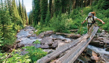
'Gimli Creek on the Valhalla Traverse (Steve Howe)'
Explore an alpine wonderland reminiscent of the Swiss Alps—but with a fraction of the traffic—on this 11.7-mile, three-day point-to-point in 123,288-acre Valhalla Provincial Park, 150 miles due north of Spokane. You’ll get up-close with flower-speckled meadows and the steepest and finest granite spires in B.C.’s imposing Selkirk Range.
Beginning from the Drinnon Pass trailhead just south of Slocan City, climb two miles on a well-marked trail past spruce-ringed pocket lakes near timberline. Hit 6,739-foot Drinnon Pass, with views north to the rugged Devil Range. Leave the trail to traverse steeply southeast, climbing 800 vertical feet of talus to a saddle on the north shoulder of Drinnon Peak.
Drop north off the pass down gentler, grassier slopes, following a timbered ridgeline north-northeast to locate an obscure gully that descends diagonally back south, through thick brush and grass, to an unnamed yet obvious pond. From here, climb east through a half mile of boulders to Valhalla Lake. For more open and scenic lakeside camping, continue another .6 mile to a chain of ponds atop tundra shelves at the western foot of pyramid-shaped Asgard Peak.
ADVERTISEMENT
Next morning, cross the northeast shoulder of Asgard via a half day of rugged boulder-hopping. Or go technical: Use ice axe, rope, and crampons to climb straight up a prominent 40-degree, snow-filled gully southwest of Asgard’s 9,268-foot summit. Either route drops you east and south down steep meadows into Mulvey Basin, where ice-filled Mulvey Lake sits surrounded by the staggeringly steep granite spires of Mt. Dag, Wolf’s Ears, and Gimli. Keep your eyes peeled for grizzlies and mountain goats.
Finish by climbing a rough mile over year-round snow, followed by a short, exposed rock ledge (rope recommended) to Gimli Col, a tiny rock saddle perched beneath thousand-foot granite walls. Close out with a 2.2-mile stroll down the Gimli Peak Trail. You’ll need two cars for the 24-mile, dirt-road shuttle—it’s too quiet to hitch.
MapNTS quad 082F13; $16CAD for waterproof versions; (888) 545-8111; fedmaps.com
PermitBackcountry $5CAD/person/night
GuideSummit Mountain Guides; (250) 354-4884; summitmountainguides.com
Contact (250) 354-6333; bcparks.ca
Cost DIY $/Guided $$$$$*
Map & GPS databackpacker.com/hikes/1395678
>> Online Trip Planning Extras
Get There Start from Slocan City, on Highway 6 north of Castlegar in south-central B.C, about halfway between Vancouver and Calgary. Exit Slocan south on the graveled Little Slocan Valley Forestry Road, following signs for Valhalla Park and Gwillim Lakes, 27 miles to the Drinnon Pass trailhead.
Nakusup (Valhalla Provincial Park gateway)
>> Lodging and restaurant: Halcyon Hot Springs Resort (rooms, luxury cabins, multiple pools for swimming, hot tubbing), (250) 265-3554; halcyon-hotsprings.com
New Denver (Valhalla Provincial Park gateway)
>> Lodging: Villa Dome Quixote (very unique and beautiful eco-dome cottages, hot tub, area info, good biking area), (250) 358-7242; domequixote.com