Published February 5, 2015 06:59AM
Devils Dome Loop, Washington
Score Swiss-Alps scenery without the trans-Atlantic flight.
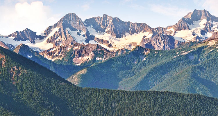
'Overlook Devils Park and the Cascade Crest from the Jackita Ridge Trail in the Pasayten Wilderness. (Andy Porter)'
The numbers: 43 miles, 5 to 6 days
The hike: The devil looms large on this rugged loop—you’ll pass Devils Creek, Pass, Park, Junction, and Dome—and you may curse like Satan during the initial 3,300-foot, 4-mile climb to McMillan Park. Then, you’ll swear you’re in heaven, enraptured by views over alpine meadows jammed with summer paintbrush, columbine, and lupine and dotted with stately firs and larches. Follow the Jackita Ridge and Devils Ridge Trails as you roll along the ridges of the Pasayten Wilderness to the east and north of ice-draped Crater Mountain and 9,066-foot Jack Mountain. The latter’s broad Nohokomeen Glacier fills your camera viewscreen like a scene straight out of Switzerland. At mile 20, camp atop Devils Dome for sunset and sunrise views over the endless peaks of British Columbia and west to Mt. Baker, then drop to the turquoise waters of Ross Lake. If you’re short on time, you can shortcut the route by catching a water taxi down the lake, but the 13-mile shore hike along the East Bank Trail makes a beautiful way to end the hike.
TRIP PLANNER
ADVERTISEMENT
Trailhead 48.706524, -120.918482; Canyon Creek, milepost 141 on WA 20, 36 miles east of Marblemount
Red tape free NPS backcountry permit for camping at Ross Lake (obtain at Marblemount ranger station); plus Northwest Forest parking pass
Season Mid-July to mid-September