Updated December 3, 2024 06:25PM
Denali National Park: Mount Eielson Loop
This 14.6-mile hike in Denali National Park circles Mount Eielson and features scenic creek crossings and jaw-dropping views of the Alaska Range.
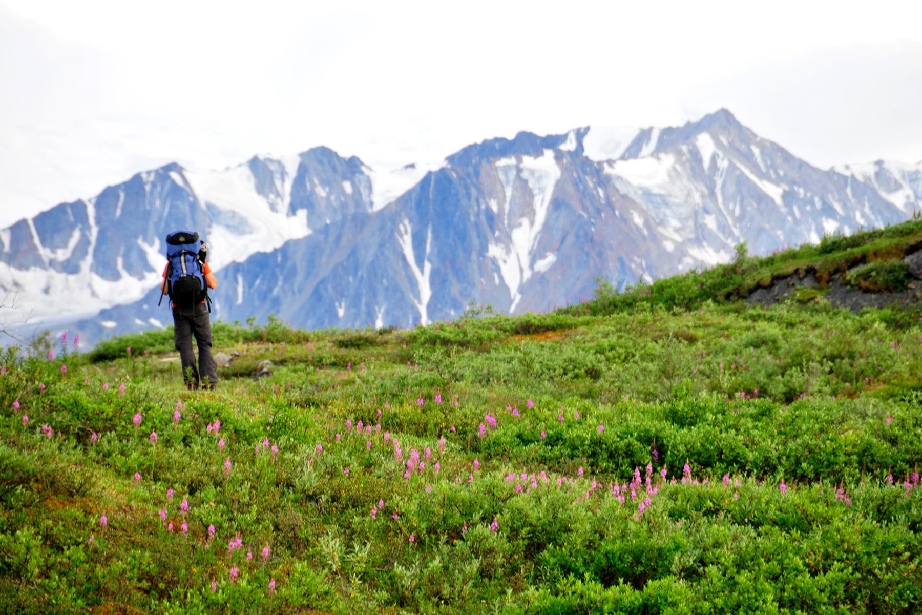
Located at the foot of the Alaska Range in Denali National Park, this 14.6-mile route circles 5,802-foot Mount Eielson and offers incredible views of glacier-capped mountains—and on clear days, Mount Denali. Pick up your backcountry permit and a bus pass, then park your car at the Riley Creek Campground overflow lot. Take the Camper Bus to a pull-out on Grassy Pass, located 2.2 miles west of Eielson Visitor Center.
From Grassy Pass, pick up the social trail that cuts across the lush hillside and leads to a rock-strewn chute (make noise: black and grizzly bears live in the park). Descend this steep gully, then hike south-southwest across an expansive gravel bar, crossing the braided channels of the Thorofare River (vibrant wildflowers cover the ground). Near mile 2, continue past the Glacier Creek drainage and ascend a small ridge with big views of Mounts Mather, Deception, and Brooks. Next, bushwhack southeast back to the Glacier Creek drainage and follow the creek south to the Intermittent Creek drainage (mile 5.1). From here, it’s a 1.5-mile climb to a sweet campsite perched above the valley.
ADVERTISEMENT
On day two, continue the climb up the Intermittent Creek drainage to a broad saddle located between Intermittent Creek and Wolverine Creek. Drop your pack for a short, 0.6-mile side trip to a nearby ridgetop (clear days reveal Mount Denali to the southwest). Soak up the spectacular views, then backtrack to the saddle and follow animal trails that lead to the headwaters of Contact Creek. Descend this mile-long drainage to the Thorofare River gravel bar, and head north for the return trip to Eielson Visitor Center.
The next 4-mile stretch feature numerous stream crossings. Use caution when picking your route through the countless channels (the water temperature is roughly 36ºF). At mile 13.6, bear right into the Gorge Creek drainage and head northeast for 0.3 mile to a small cairn marking an overgrown trail to the visitor center. Yell “Hey Bear” as you climb through the tall bushes flanking both sides of the path. The route ends at Eielson Visitor Center; catch a shuttle bus back to the Riley Creek parking area.
Note: There is no established trail system in Denali’s backcountry. Map and compass skills are required.
PERMIT: Overnight camping in Denali National Park requires a backcountry permit.
CONTACT: Denali National Park, (907) 683-2294;
ZONE INFORMATION: Unit 12 and Unit 13.
-Mapped by Kim Phillips and Matt Vellone


ADVERTISEMENT
Trail Facts
- Distance: 23.5
Waypoints
EIE001
Location: 63.426235, -150.374439
ADVERTISEMENT
This backcountry route starts at a small pull-out on Grassy Pass. Head northwest to pick up the social trail that winds across the grassy slopes above the Thorofare River. Make sure to yell, “Hey Bear” throughout your trip.
EIE002
Location: 63.426551, -150.375946
Follow the social trail that winds southwest. Views of the Alaska Range dominate the southern horizon.
EIE003
Location: 63.423815, -150.379443
This vantage point offers sweet views of the Thorofare, a river with braided channels that runs across the broad gravel bar below. Next, descend the chute to reach the gravel bar.
EIE004
Location: 63.42226, -150.378671
The pace quickens as the route travels southwest across the gravel bar, passing brilliant pink wildflowers.
EIE005
Location: 63.413243, -150.384872
Prepare to get your feet wet as the terrain becomes more marshy and the route crosses ankle-deep channels of the Thorofare.
EIE006
Location: 63.404427, -150.398476
Pass the Glacier Creek drainage on the left. Hike west, then northwest to ascend bushy slopes with dramatic views of the Alaska Range. Shortcut: To decrease mileage and bypass the hillier terrain, head south up the Glacier Creek drainage to connect with Waypoint 9.
EIE007
ADVERTISEMENT
Location: 63.40604, -150.40427
Bear left, heading southwest.
EIE008
Location: 63.405503, -150.407588
Crest the top of a small ridge and bushwhack south, then southeast toward the Glacier Creek drainage.
EIE009
Location: 63.397614, -150.395311
Reconnect with the Glacier Creek drainage at mile 3.2. This flat spot is a good place to grab a snack. Next, turn right and hike into the drainage.
EIE010
Location: 63.392185, -150.393541
The route parallels Glacier Creek for the next mile.
EIE011
Location: 63.383576, -150.384666
Hike past boulders along the creekbed. Rugged, glacier-covered mountains tower above the landscape to the south.
EIE012
Location: 63.377542, -150.379218
This flat spot above the river is a scenic place to set up camp.
EIE013
Location: 63.374852, -150.374937
Cross the many channels of Glacier Creek en route to the Intermittent Creek drainage.
EIE014
Location: 63.374059, -150.373285
ADVERTISEMENT
You have 2 options at this point: 1. Turn left and hike into the Intermittent Creek drainage; 2. Continue straight to briefly explore the hill that borders the Intermittent Creek drainage.
EIE015
Location: 63.37389, -150.367051
The route climbs up the stark drainage, tracing Intermittent Creek, a gurgling (and clear) stream that runs down the rocky slopes.
EIE016
Location: 63.373706, -150.337759
Scree covers the slopes along this stretch.
EIE017
Location: 63.373645, -150.333577
Bear left at the foot of the ridge and stay in the Intermittent Creek drainage.
EIE018
Location: 63.374511, -150.32993
Intermittent creek disappears below ground.
EIE019
Location: 63.374602, -150.32817
Leave the drainage and hike up the grassy slopes on the right.
EIE020
Location: 63.374325, -150.327827
Crest the grassy ridgetop (a great place to set up camp) and take in the sweeping views west toward the Muldrow Glacier and small glacial lakes. Next, continue to climb northeast.
EIE021
Location: 63.37564, -150.320145
On cloudless days, views of Mount Denali start to appear at this point.
EIE022
Location: 63.376117, -150.308021
ADVERTISEMENT
Drop your packs on the saddle perched above Intermittent Creek and Wolverine Creek for a short, 0.6-mile side trip to a nearby ridgetop.
EIE023
Location: 63.373756, -150.314341
Soak up spectacular views of the Alaska Range from this grassy ridge. Look high in the sky for the summit of Mount Denali.
EIE024
Location: 63.376981, -150.303073
Yell “Hey Bear” to hear your voice echo off the rock walls.
EIE025
Location: 63.377198, -150.299277
Cross Wolverine Creek and follow the animal trails that hug the side of the mountain.
EIE026
Location: 63.376428, -150.292848
Begin the mile-long descent into the Contact Creek drainage.
EIE027
Location: 63.380006, -150.266125
Cross Contact Creek and bear left, heading north along the gravel bar.
EIE028
Location: 63.395443, -150.278034
The return trip to Eielson Visitor Center features numerous stream crossings. Use caution when picking your route through the channels. (Note: The water temperature is roughly 36ºF. Hikers that fall into the water have a high risk of getting hypothermia.) For water crossing tips, go to nps.gov/dena/planyourvisit/crossings.htm.
EIE029
Location: 63.40531, -150.292239
ADVERTISEMENT
Be careful crossing this thigh-high and fast-moving stretch of water, which runs around the base of two headlands.
EIE029
Location: 63.42307, -150.317411
A cairn marks an overgrown trail that climbs up to the Eielson Visitor Center. Make a lot of noise: Tall bushes flank both sides of the path.
EIE030
Location: 63.431148, -150.311176
The route ends at Eielson Visitor Center. Take a shuttle bus back to the Riley Creek Campground overflow parking area.
Glacier Creek
Location: 63.378194, -150.380781
Grassy Pass
Location: 63.426435, -150.376188
The Thorofare
Location: 63.426072, -150.37681
Wildflowers
Location: 63.423844, -150.379633
Alaska Range
Location: 63.4237, -150.379143
Rocky Chute
Location: 63.423815, -150.379325
Scenic Viewpoint
Location: 63.423837, -150.379665
Views of the Alaska Range
Location: 63.420905, -150.379394
Wildflowers
Location: 63.414594, -150.383896
Alaska Range
Location: 63.414476, -150.384182
Gravel Bar
Location: 63.404687, -150.397007
Grassy Ridge
Location: 63.405415, -150.40766
Glaciers
Location: 63.405363, -150.407714
Views of the Glacier Creek Drainage
Location: 63.399, -150.404388
Trail Views
Location: 63.397665, -150.400023
Glacier Creek
Location: 63.390051, -150.391975
Land of the Midnight Sun
Location: 63.383729, -150.384461
ADVERTISEMENT
Campsite near Glacier Creek
Location: 63.37764, -150.379271
Glacier Creek
Location: 63.377698, -150.379454
Views above Glacier Creek
Location: 63.373454, -150.373232
Intermittent Creek Drainage
Location: 63.373454, -150.373232
Views of the Muldrow Glacier
Location: 63.374391, -150.327895
Caribou
Location: 63.374828, -150.32603
Grassy Perch
Location: 63.373765, -150.314062
Views of Castle Rock
Location: 63.376157, -150.308691
Castle Rock and the Wolverine Creek Drainage
Location: 63.377045, -150.302889
Path above Wolverine Creek Drainage
Location: 63.377131, -150.29887
Contact Creek Drainage
Location: 63.376506, -150.292411
Hoary Marmot
Location: 63.379352, -150.268099
Gravel Bar
Location: 63.380015, -150.265868
Gravel Bar
Location: 63.387582, -150.270417
Thorofare River
Location: 63.393576, -150.275976
Thorofare River
Location: 63.393576, -150.275976
Gravel Bar
Location: 63.393929, -150.276574
Mount Eielson
Location: 63.393929, -150.276574
Stream Crossing
Location: 63.394057, -150.27671
Thorofare River Gravel Bar
Location: 63.396158, -150.278292