Death Valley National Park: Eureka Dunes to Last Chance Mountain

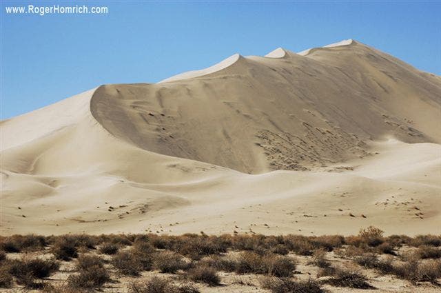
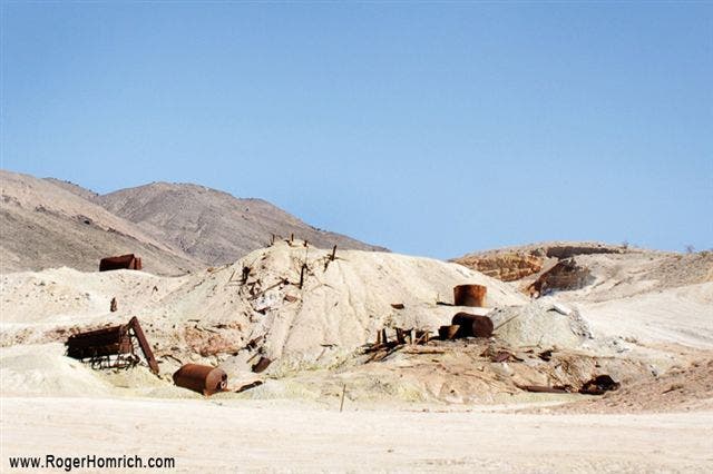
Hike north from S. Eureka Road for a moderate climb into the Last Chance Range. Make sure to turn around for views of the 700-foot Eureka Dunes, the highest dunes in California and some of the tallest in the U.S. The route passes another viewpoint that showcases the dunes and the snowy Inyo Range at mile 1.7. One mile later, the terrain flattens briefly between two 4,000-foot foothills, then continues north, following the canyon’s wash. (Keep left at the two forks in the canyon). After 6 miles, turn left onto Big Pine Road and follow it to Crater Mine. Just past the mine, hikers can set up camp off the dirt road on a flat area near the pass. Pick a spot with protection—this area can get very cold and windy.
The next day, follow the dirt road until it dead ends into the mountains. From here, you’ll scramble up a steep, dirt slope to the first saddle in Last Chance Range. From the saddle, follow the ridgeline over 4 unnamed peaks to Last Chance Mountain. Route-finding will be necessary for this stretch to Last Chance Mountain—there is no trail and the terrain is extremely rugged. From the top of 8,456-foot Last Chance Mountain, savor views into the Last Chance Range, then turn around and follow the same route back to Eureka Dunes.
Note: Route-finding skills are required for this route.
-Mapped by Roger Homrich, the first person to thru-hike Death Valley Traverse.


Trail Facts
- Distance: 23.1
Waypoints
EDL001
Location: 37.1149178, -117.6644325
Hike north from S. Eureka Road. Make sure to turn around for views of the 700-foot Eureka Dunes, the highest dunes in California and some of the tallest in the U.S.
EDL002
Location: 37.139167, -117.6716757
Take a moment to stop and look around at this overlook, which showcases the dunes below and the snowy Inyo Range. Continue north-northwest through the narrow valley between the foothills.
EDL003
Location: 37.1514633, -117.6782539
After climbing another 400 feet, rest at this open, flat area between two 4,000-foot foothills. Continue north through the canyon, following the wash. The canyon walls are a few hundred feet higher than the wash.
EDL004
Location: 37.1721031, -117.6719435
Bear left at an intersection between two canyon washes. Continue three-quarters of a mile over gravel, passing beautifully colored canyon walls before reaching another fork in the canyon.
EDL005
Location: 37.1857649, -117.6748443
Bear left at the second fork in the canyon. Once the canyon opens, continue northwest to Big Pine Road.
EDL006
Location: 37.1925223, -117.680448
Follow Big Pine Road to the left and continue westward to Crater Mine.
EDL007
Location: 37.2117204, -117.6909214
After bearing left onto Big Pine Road, turn right and continue north past the mining area.
EDL008
Location: 37.2202135, -117.6841736
Camp off the dirt road on a flat area near the pass. Pick a spot with protection because this area can get very cold and windy. From camp, follow the dirt road until it dead ends into the mountains. A mineshaft is at the end of the road. Route-finding will be necessary for the remaining stretch to Last Chance Mountain (there is no trail and the terrain is extremely rugged).
EDL010
Location: 37.2589589, -117.6814071
Scramble up a steep, dirt slope to the first saddle in Last Chance Range. From the saddle, hike the ridgeline over 4 unnamed peaks to Last Chance Mountain. Head northwest to the first peak (7,853 feet). Go north-northwest to the second peak (7,978 feet). Continue northwest to the third peak (8,250 feet). Then, head due north and turn east, skirting the ridgeline around the fourth peak (8,211 feet). Hike north, then northwest along the ridge to the summit of Last Chance Mountain (8,456 feet).
EDL011
Location: 37.2801412, -117.6998083
Last Chance Mountain (8,456 ft.): Savor views from the trip’s high point, then turn around and follow the same route back to Eureka Dunes.
Eureka Dunes
Location: 37.114336, -117.6608276
©Roger Homrich
Crater Mine
Location: 37.2116695, -117.6899242
©Roger Homrich