Published June 10, 2019 06:02PM
The Crawford Path at 200
This New Hampshire footpath— the oldest continuously maintained hiking trail in the country—is a rite of passage for anyone who cares about America’s history of preserving and exploring wild places.
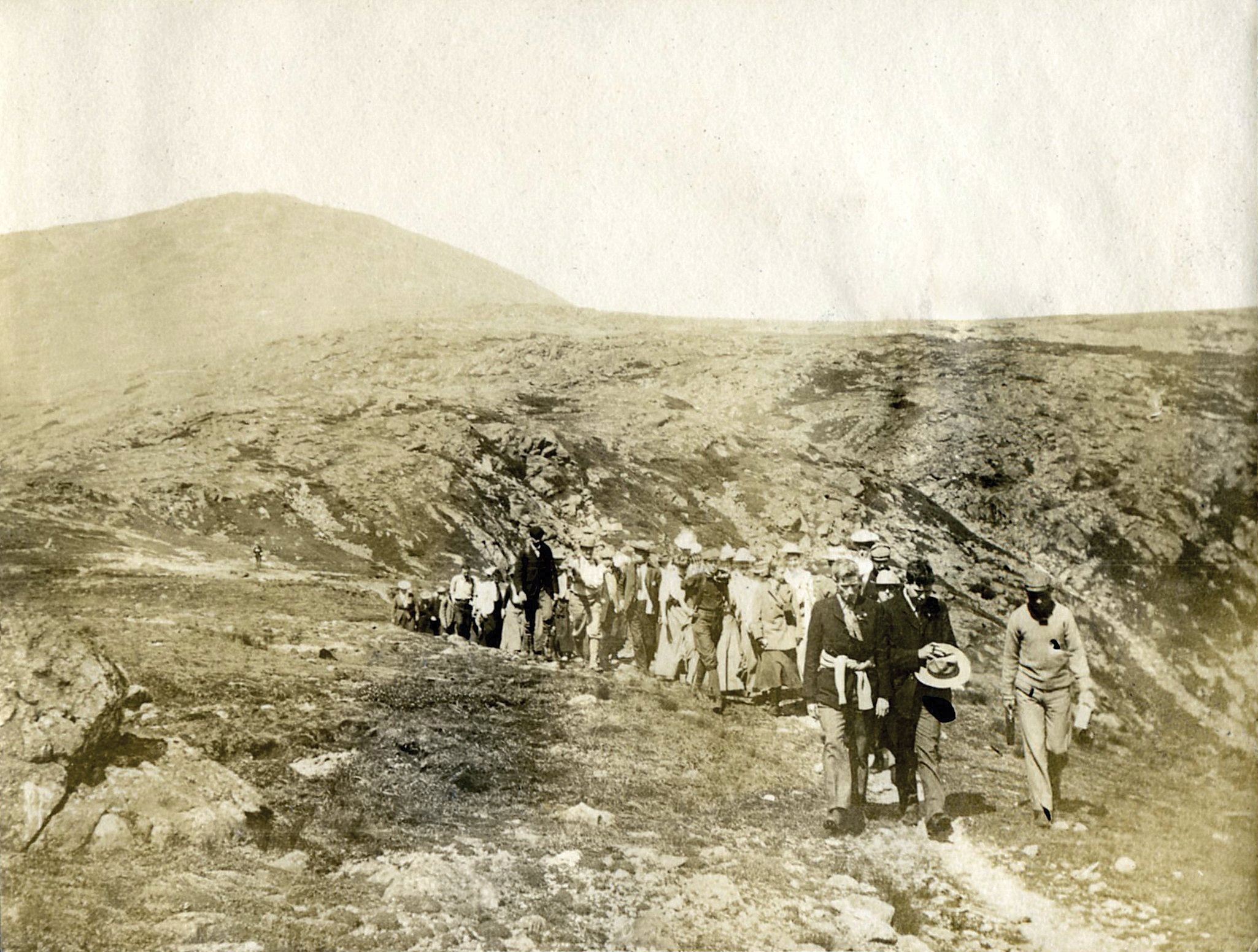
'Courtesy of the Appalachian Mountain Club Library and Archives'
Climbing mountains for the sake of climbing mountains has been, for most of history, a funny thing to want to do. For eons, peaks were a nuisance to travel at best, and at worst, a danger zone where gods, not people, ruled. And New Hampshire’s White Mountains, formed some 400 million years ago, were some of the New World’s most treacherous.
Scoured for millennia by glaciers, then covered with impenetrable forests, the White Mountains didn’t exactly put out the welcome sign, despite that the Abenaki tribe called the area home. So it’s anyone’s guess why sometime around 1791, Abel Crawford moved his wife and two sons from Vermont to a desolate pass amid some of the young nation’s tallest-known peaks. Around the same time, however, mountain climbing was catching on as recreation, and soon the peaks where the Crawfords lived—particularly the highest, 6,288-foot Mt. Washington—became something people wanted to see.
It didn’t take long for Crawford to see the potential for tourism. He began supplementing his homesteading by offering beds to visitors, eventually building a collection of inns. But there was still the matter of fighting through trees and brush to reach Mt. Washington’s summit. In 1819, the Crawfords set to work cutting a route to the top.
ADVERTISEMENT
Originally little more than a vague collection of markings on trees, the route sliced through thick krummholz to treeline, then continued up a broad ridge and over a series of smaller peaks before ascending the rocky summit cone.
The Crawfords soon constructed a second summit route, a series of huts, and converted the original trail into a bridle path. Eventually, the family moved on, but the name stuck and Crawford Notch became the adventure hub it is today.
The Crawfords’ original trail was maintained in part by one of the country’s earliest hiking groups, the Appalachian Mountain Club, founded in 1876. Despite 200 years of hiking boots, the trail would likely still be familiar to the pioneer family that built it: a narrow, winding, rocky path along the skyline.
What’s best on the Crawford Path?
We asked Zach Urgese, AMC’s White Mountains Trail Supervisor.
1. Waterfall Just under a half mile up the trail from Crawford Notch, stop at Gibbs Falls to see a 35-foot cascade that tumbles over rocky ledges into a pebble-bottomed pool (best in spring). A foot soak is all but mandatory on the return trip.
2. Overnight Camping is prohibited above treeline north of Mt. Pierce unless there’s 4 or more feet of snow on the ground. If you want to stretch the hike into two days, split off from the Crawford Path at mile 1.6 and take the Mizpah Cutoff and Appalachian Trail for .8 mile to Nauman Tentsite ($10/person per night; first-come, first-serve), tucked in the trees alongside the Appalachian Mountain Club’s Mizpah Spring Hut.
3. Treeline After climbing 2.7 miles through the Gibbs Brook drainage, break out of the trees near the summit of 4,310-foot Mt. Pierce. The trail bounces in and out of pockets of stunted balsam fir, but you’ll enjoy big views from here to the summit.
4. Wraparound views Mt. Eisenhower culminates in a genteel, bald dome, and because of its position near the center of the Southern Presidentials, the views extend along the entire route. A .6-mile loop departs the Crawford Path around mile 3.8 and runs up and over Eisenhower’s 4,780-foot summit. This side trail, as well as another over Mt. Monroe, is well worth the extra effort.
5. Refuge When two Appalachian Mountain Club members died in a midsummer snow storm in 1900, the AMC decided a refuge was needed near the summit of Mt. Washington. By 1915, a small stone shelter stood by a collection of glacial tarns. Today, the AMC’s Lakes of the Clouds Hut—renovated and rebuilt several times over the years—sleeps 90 (up to $145/person per night).
6. Reroute The Crawford Path itself has shifted through the years, most notably here. The early route took a less direct but more moderate path through the Bigelow Lawn. Look for a faint indent in the grass, rocks pushed aside, or even broken cairns heading east-northeast between the Camel Trail and the Davis Path.
7. Tiny life Keep a sharp eye to the ground (without wandering off-trail) in search of the extremely rare dwarf cinquefoil. The tiny, yellow flower exists only in a couple patches in the White Mountains’ alpine zones, including Monroe Flats, surrounding Lakes of the Clouds.
8. Steepest climb Tighten your laces for the final 1.4 miles and 1,200 vertical feet to the top. Expect steep boulder hopping and balancing across loose rock fields, not to mention, you’re climbing an exposed side of a mountain that is home to some of the world’s worst weather and fiercest wind (strongest recorded gust: 231 mph on the summit in 1934).
9. Highpoint The first building on top of Mt. Washington—a hotel known as The Summit House—opened in 1852, and a year later the Tip-Top House was built to compete. The Summit House burned down in 1908 but the Tip-Top House survived. Look for the low-slung rock building just a few yards from the summit sign, near the parking lot and visitor center.
ADVERTISEMENT
Crawford Path Stats
8.5 miles long with 4,961 feet of elevation gain
Designated as a National Recreation Trail in 1994
ADVERTISEMENT
First documented ascent of Mt. Washington: 1642 by Darby Field
6,000,000 annual visitors to White Mountain National Forest