Heading out the door? Read this article on the new Outside+ app available now on iOS devices for members! Download the app.
-Mapped by Timm Paxson
©Timm Paxson


Trail Facts
- Distance: 11.1
Waypoints
4WD road that leads to the trail
Location: 38.7449378967285, -106.204788208008
©Timm Paxson
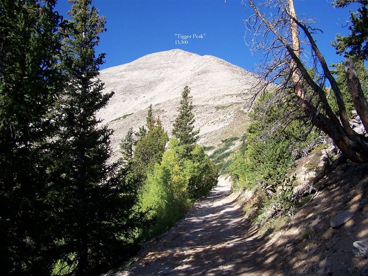
“Tigger Peak”
Location: 38.7466506958008, -106.211929321289
The unofficial name of the 13,330-foot peak southeast of Princeton. (The Princeton mascot is the tiger.) The road turns south at the bend ahead, and the trail leaves the road in a northerly direction.
©Timm Paxson
Stone steps
Location: 38.7444610595703, -106.215553283691
A cairn and steps mark the trail’s beginning. Note that about 100 feet down the road from this point, people have created a shortcut. Use this path instead.
©Timm Paxson
Alpine tundra
Location: 38.74560546875, -106.218406677246
The trail climbs a ridge of “Tigger Peak” from the south then bends to the west where the summit of Princeton can be seen. Part of the trail can be seen center left of the photo.
©Timm Paxson
Rocky slopes
Location: 38.7446517944336, -106.223930358887
The trail abruptly leaves the tundra zone and the rest of the climb is through rocks.
©Timm Paxson
Trail views
Location: 38.7446517944336, -106.229736328125
The trail continues across the rock to an abandoned mine at 13,100 feet.
©Timm Paxson
The ridge
Location: 38.7437019348144, -106.231262207031
The ridge climb is through rocks interspersed with hints of a trail.
©Timm Paxson
Tigger Peak and the Arkansas River Valley
Location: 38.7434158325195, -106.230499267578
Looking east down the trail from the ridge. “Tigger Peak” is on the right hand side of the photo.
The Arkansas River valley is in the background.
©Timm Paxson
The summit pyramid
Location: 38.748462677002, -106.241737365723
Looking up at the summit.
©Timm Paxson
Looking down from the summit
Location: 38.7482719421387, -106.241645812988
©Timm Paxson
Summit views
Location: 38.7491302490234, -106.242500305176
©Timm Paxson
PTN001
Location: 38.7385711669922, -106.17911529541
From the parking area, follow 4WD road for 3.2 mi. to upper parking area
PTN002
Location: 38.7452850341797, -106.200592041016
Road swings to the W; pass 4WD parking
PTN003
Location: 38.7448234558106, -106.206398010254
Pass second 4WD parking area; continue dirt road ascent, climbing through several switchbacks
PTN004
Location: 38.7444534301758, -106.215370178223
Turn R and leave the road @ jct. marked with a cairn; climb stone steps
PTN005
Location: 38.7458114624023, -106.21704864502
Head W across alpine tundra; pass an old mine
PTN006
Location: 38.7447357177734, -106.223213195801
Head W; traverse the rocky slopes below “Tigger Peak”
PTN007
Location: 38.7448921203613, -106.230361938477
Bear L @ fork marked with cairns to ascend Princeton’s SE ridge
PTN008
Location: 38.7437438964844, -106.231063842773
Turn R on ridge connecting Mt. Princeton and “Tigger Peak” (marked with 2 cairns); pass remains of an old mine
PTN009
Location: 38.7445907592773, -106.234313964844
Pass remnants from another old mine
PTN010
Location: 38.7453765869141, -106.236198425293
Head NW, passing a stone wall and an old mine
PTN011
Location: 38.7470092773438, -106.239791870117
Stay straight @ jct. with trail that enters from the R
PTN012
Location: 38.7483673095703, -106.241645812988
Final summit push on boulder-covered slopes (only 200 ft. left to climb)
PTN013
Location: 38.7492256164551, -106.242500305176
Mt. Princeton (14,197 ft.): Summit views into San Isabel National Forest to the N and S. Look SE down the ridge to find “Tigger Peak.” Retrace steps to trailhead