Published September 20, 2013 02:40PM
Colorado 14ers: Mount Belford, Mount Oxford and Missouri Mountain
String together three Sawatch summits on this popular circuit with long alpine traverses overlooking the Continental Divide.
-Mapped by Timm Paxson


Trail Facts
- Distance: 16.4
Waypoints
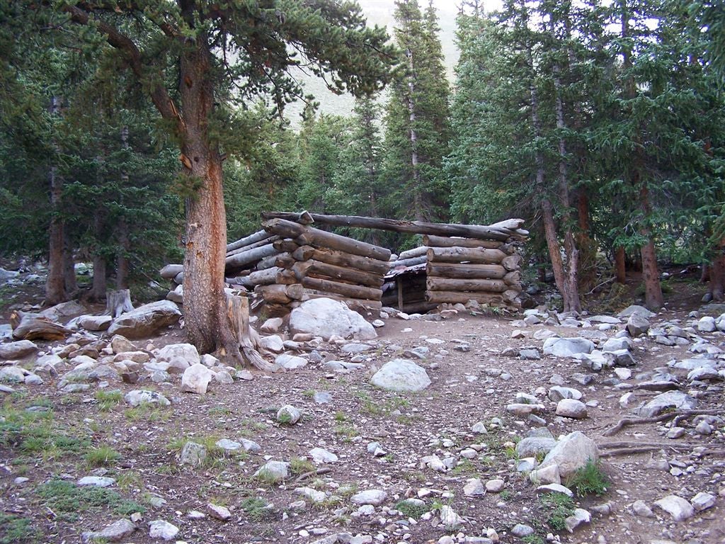
Log Cabin
Location: 38.9814987182617, -106.374015808105
An old log cabin which was built just below treeline in Missouri Gulch.
©Timm Paxson
Missouri Gulch
Location: 38.977840423584, -106.373054504395
The view north down into Missouri Gulch.
©Timm Paxson
Looking south toward Missouri Mountain from Missouri Gulch
Location: 38.9635963439941, -106.37718963623
The trail climbs the tundra on the far side of the rocky bluff in front of the main ridge.
©Timm Paxson
Views of the saddle
Location: 38.9560928344727, -106.38037109375
The trail climbs to the saddle at the top of this ridge. The trail is hidden behind the lower rock feature rising up from the tundra.
©Timm Paxson
Huron Peak
Location: 38.9539756774902, -106.386528015137
Views of Huron Peak to the west from the ridge saddle.
©Timm Paxson
La Plata Peak
Location: 38.9538803100586, -106.38671875
Views of La Plata Peak to the northwest from the ridge saddle.
©Timm Paxson
Missouri Mountain
Location: 38.9525299072266, -106.385948181152
ADVERTISEMENT
Looking southeast along the Missouri Mountain ridge towards the summit.
©Timm Paxson
Views of the trail
Location: 38.9520492553711, -106.384986877441
The trail up the ridge to Missouri Mountain’s summit.
©Timm Paxson
Missouri Mountain summit views
Location: 38.9475288391113, -106.378639221191
Mount Harvard (14,420), Mount Columbia (14,073), and Mount Yale (14,196) command the summit view to the south.
©Timm Paxson
Summit Views
Location: 38.9478149414062, -106.378639221191
Looking east from the summit of Missouri Mountain, views stretch toward Mount Belford (14,197) and Mount Oxford (14,153).
Summit Views of La Plata Peak
Location: 38.9477195739746, -106.378730773926
Looking north along the ridge toward La Plata Peak (just right of center).
Rocky gully
Location: 38.9542617797852, -106.380172729492
Looking up at scree-filled gully.
©Timm Paxson
Missouri Mountain from Elkhead Pass
Location: 38.9517631530762, -106.366508483887
©Timm Paxson
Trail from Elkhead Pass
Location: 38.9513778686523, -106.364776611328
The trail first leads east from Elkhead Pass, then bends around to the north to reach Oxford and Belford.
©Timm Paxson
Views of Mount Oxford
Location: 38.9599418640137, -106.359970092773
ADVERTISEMENT
Mount Oxford as seen from just below the summit of Belford.
©Timm Paxson
Mount Oxford summit
Location: 38.9648475646973, -106.338890075684
The view to the west from Oxford’s long summit.
©Timm Paxson
Mount Belford’s summit
Location: 38.9610977172852, -106.36247253418
Views to the east, looking back at Belford’s summit.
©Timm Paxson
Pecks Peak
Location: 38.9629249572754, -106.365455627441
Looking north down the trail toward Pecks Peak.
©Timm Paxson
Views into Missouri Gulch
Location: 38.9657135009766, -106.368049621582
Missouri Gulch from the
west face of Belford.
©Timm Paxson
Grave near the trail
Location: 38.997184753418, -106.374496459961
The only grave left in the cemetery near the trailhead.
©Timm Paxson
BOM001
Location: 38.9978866577148, -106.375015258789
From Missouri Gulch trailhead, head S and cross bridge over Clear Creek
BOM002
Location: 38.9935111999512, -106.372932434082
Begin ascent into Missouri Gulch through steep switchbacks
BOM003
Location: 38.9855918884277, -106.373115539551
Cross stream on log bridge; continue S through Missouri Gulch
BOM004
Location: 38.9814987182617, -106.373924255371
Pass an old log cabin, then leave forest behind; watch for deer on slopes
BOM005
Location: 38.9742279052734, -106.37321472168
ADVERTISEMENT
Bear R @ Belford-Oxford fork, or find campsites near trail
BOM006
Location: 38.9701957702637, -106.373573303223
Head S through alpine tundra; stream flows beside trail; cairns lead the way
BOM007
Location: 38.9557838439941, -106.376564025879
Bear R and ascend grassy slopes where the trail to Elkhead Pass heads to the SE; follow cairns
BOM008
Location: 38.9550552368164, -106.386299133301
Head S from the saddle; look W for views of Huron Peak; La Plata Peak silhouetted to the NW
BOM009
Location: 38.9529838562012, -106.386840820312
Head SE on rocky ridgeline towards summit
BOM010
Location: 38.9475593566894, -106.378540039062
Missouri Mtn. summit (14,067 ft.): Mounts Harvard, Columbia and Yale command the summit view to the S. Look E for views of Mt. Belford and Mt. Oxford
BOM011
Location: 38.9512214660644, -106.382766723633
Optional descent: Glissade down several scree fields; then head NE across alpine tundra to reconnect with Elkhead Pass Trail
BOM012
Location: 38.955078125, -106.376274108887
Turn R @ jct. onto Elkhead Pass Trail; head SE towards pass; cairns lead the way
BOM013
ADVERTISEMENT
Location: 38.9516143798828, -106.366325378418
From Elkhead Pass, head NE following cairns
BOM014
Location: 38.9580497741699, -106.358169555664
Veer R @ Y; follow ridgeline to the NE toward Belford-Oxford Saddle
BOM015
Location: 38.9593658447266, -106.350845336914
Continue NE along saddle, then ascend Oxford’s W ridge to summit
BOM016
Location: 38.964771270752, -106.338798522949
Mt. Oxford (14,153 ft.): Enjoy views from Oxford’s broad summit. Retrace steps to WPT 14 and turn R to tackle Mt. Belford
BOM017
Location: 38.9607086181641, -106.360694885254
Mt. Belford summit (14,197 ft.): Relish panoramas from 14,000 ft. for the third time; head NW to descend Belford
BOM018
Location: 38.9631576538086, -106.36572265625
Descend grassy slope on switchbacks
BOM019
Location: 38.9710464477539, -106.370536804199
Continue NW to WPT 5; turn R and retrace steps to trailhead