Updated December 3, 2024 09:50PM
Coastal Hiking Trail, Pukaskwa National Park
Hug pebbly beaches and cliffs along Superior shores.
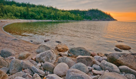
'The sun fades over Lake Superior from North Swallow Harbor (Steve Howe)'
Canada’s most populous province is a land of lakes—Great ones. For an untamed taste of the world’s largest stretch of freshwater, check out Superior’s North Shore, where Ice Age glaciers and storm-tossed waves have sculpted the granite coastline into a wilderness of steep hills and deep gorges with a sprinkling of stunted evergreens.
Ontario’s largest park, Pukaskwa, sees just 10,000 annual visitors, most of whom stay close to their car. Set off on foot to wander virtually alone through boreal forest full of wolf, black bear, and moose.
Pukaswka’s only backcountry route is a sweet one: 37.8 miles of rolling trail, sometimes hard to follow, along rocky coast dotted with beach-front campsites. The track reopened in 2011 after a three-year rebuild of two suspension bridges.
For a five-day itinerary, hire a boat shuttle (pricy) or turn around at Oiseau Bay. Better yet, hike the whole thing as a 76-mile out-and-back. Either way, build in bad-weather days; the route’s granite slabs turn super-slick when wet.
ADVERTISEMENT
Start from the Hattie Cove Visitor Center and travel occasionally marshy track through black spruce, jack pine, white birch, and aspen. Cross the White River on Chigamiwinigum Gorge Bridge (mile five), then climb bare granite domes and slabs to Willow Bay (mile 10.2), with excellent camping on a long, curving sand beach. From there to Oiseau Bay’s expansive beachside views (mile 19), the trail hugs the coast past five inlets dotted with rocky islands.
South of Oiseau, the last 16 miles are more rugged and less well-marked. The section begins with cliff-brink walking en route to Fisherman’s Cove, followed by a strenuous trek over rocky terrain to White Gravel River at mile 29. Push on along buffed dirt trail to White Spruce Harbor (mile 31), an intimate beach camp. The last 6.8 miles to North Swallow Harbor are slow due to brush and rocky footing, but your reward is a lonely, misty beach alive with pounding surf and the haunting call of loons.
Map Crismar Pukaskwa National Park; $15CAD; (905) 852-6151; chrismar.com
Contact (807) 229-0801; pc.gc.ca
Permit Entry $6CAD/person/day; Backcountry$10CAD/person/night
Shuttle McCuaig Marine Services; $625CAD (holds 12); (807) 229-0193; mccuaigmarine@shaw.ca.
Season May through September is the best time to visit.
Map & GPS databackpacker.com/hikes/1395776
Online Trip Planning Extras
Get There Pukaskwa National Park lies on Highway 17 between airports at Sault Ste. Marie (250 miles south) and Thunder Bay (428 miles west). You can get supplies in the town of Marathon, 15 miles west of the park entrance.
Travel Contacts
Ontario General tourism info: (800) 668-2746; ontariotravel.net
Thunder Bay (major airport city)
>>Motel: Travelodge Airlane (Close to the airport, grocery stores, and Canadian Tire); (807) 473-1600
>>Transportation: Budget Rental Car (best prices our scout found); (807) 473-5040
>>Supplies: Canadian Tire (Fuel, kneepads, bug repellant, misc camping supplies, fishing licenses, tackle.);1221 Arthur Street West; (807) 475-4235
>>Groceries: Safeway; 1015 Dawson Rd;(800) 723-3929
Marathon (Pukaskwa National Park gateway)
>>Supplies: Canadian Tire (fuel, bug repellant, miscellaneous camping supplies, fishing licenses, tackle), 3 Peninsula Rd (in the mall); (807) 229-2900
>>Groceries: D H Foods Ltd, 3 Peninsula Rd (in the mall); (807) 229-0641
>>Restaurant: Rumours Coffee House; 3 Peninsula Rd (in the mall, around back) (807) 229-8350