Updated July 2, 2025 11:55AM
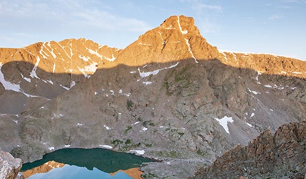
Central Rockies: Mount of the Holy Cross Loop, CO
Scramble to a remote refuge on this peak's secret side.
'The Bowl of Tears (Glenn Randall)'
All Rocky Mountain Trips | Central Rockies: Green River Lakes, WY | Central Rockies: Mount of the Holy Cross Loop, CO | Central Rockies: Highline Trail, UT | Central Rockies: Longs Peak, Rocky Mountain National Park
Want to explore one of the most sublime spots in all of the Rockies? You will on this 12-mile loop that tops out on 14,005-foot Holy Cross. The clockwise route skirts the peak’s spectacular, cross-shaped eastern cirque, ascending Notch Mountain, Halo Ridge, and Holy Cross Ridge, with in-your-face-views of the mountain all the while, and descending the standard North Ridge Trail (which gets heavy traffic).
From the trailhead at 10,300 feet, follow the Fall Creek Trail southwest for three miles, climbing switchbacks to gain the south shoulder of Notch Mountain (note: the emergency shelter located here is currently closed due to structural issues). To reach the summit from the Notch Mountain shelter, continue west, hugging the trailless ridgeline south, then west, then looping north to gain the summit after 2.75 miles and another 1,000 feet. For your descent, hop boulders and faint trail down the North Ridge, making sure you turn north at 13,400 feet to follow the ridgeline.
The Way
From Minturn, drive 2.85 miles south on US 24. Turn west on Tigiwon Road (high clearance) and continue eight miles to the trailhead.
Map
USGS quad Mount of the Holy Cross ($8, store.usgs.gov)
Contact (970) 827-5715; fs.fed.us/r2/whiteriver
Trip Data
backpacker.com/hikes/564861
Mix it Up
Ride the Monarch Crest Trail, CO.
This might be the single best one-day mountain bike ride in the country (emphasis on mountain). The 36-mile route starts at an elevation near 11,500 feet and stays there for 12 miles, with expansive views of the central Rockies all the while. But better keep your eyes on the trail—it plunges 3,800 feet down fast singletrack, through pine and aspen forest, to end in the small town of Poncha Springs. Start early to avoid thunderstorms, and pack plenty of flat repair gear. The Monarch Crest Bike Map is essential ($12; absolutebikes.com). Shuttle: High Valley Bike Shuttles, (800) 871-5145; monarchcrest.com