Published September 19, 2013 11:10PM
Capitol Reef National Park: Chimney Rock Canyon to Spring Canyon
This 10-mile, cathedral-like hallway in Capitol Reef National Park combines easy canyon hiking and foolproof routefinding with life-list sights.
You don’t need to tackle Capitol Reef’s hardest terrain to see some of its best scenery. This 10-mile, cathedral-like hallway combines easy canyon hiking and foolproof routefinding (there’s only one way to go) with life-list sights, like lush cottonwoods backdropped by massive sandstone amphitheaters. From the Chimney Rock trailhead, good trail leads into the deep cleft of Chimney Rock Canyon.
At mile 2.9 you intersect Spring Canyon and hang a right, leaving the maintained path behind. In a mile, the wash drops through a slot canyon. Explore it until an abrupt, sketchy downclimb; detour around on a trail along the left/ north rim of the narrows. The washbottom route continues past overhanging cliffs to a spring with good water at mile 6.5.
ADVERTISEMENT
Continue beneath towering cottonwoods until you ford the Fremont River (usually knee to thigh deep) and pop out on UT 24. Leave a shuttle car here, or you can hitch or bike the seven-mile return west to the trailhead (but cyclists must finish with a steep, three-mile hill climb).
WATER: You need carrying capacity for 2 gallons per person in warm weather and a filter to treat sometimes murky water. Our GPS track includes waypoints for potholes that are typically reliable, but sources can come and go.
CAUTIONS: Expect scrambling, difficult routefinding, and uncertain water sources. Never trust the rocks, which are loose. Cell reception is nil in the backcountry, so don’t count on a speedy rescue.
KEY GEAR: High-cut boots or ankle gaiters to repel grit; trekking poles; water shoes or sandals.
SEASON: Spring is popular for wildflower seekers. Late September and early October see far fewer visitors, calm blue skies, and gold cottonwoods. Summer highs reach the 90s.
MAPS: USGS 7.5-minute topos: Twin Rocks, Fruita, Golden Throne, and Notom ($8 each, store.usgs.gov)
PERMIT: Overnight camping in Capitol Reef National Park requires a free backcountry permit. Get more trip planning details at nps.gov/care/planyourvisit/hiking.htm.
ADVERTISEMENT
MORE INFO: Capitol Reef National Park, (435) 425-4111; nps.gov/care.
-Mapped by Steve Howe
TO TRAILHEAD: Start: From the park visitor center, drive west on UT 24 for 3 miles to Chimney Rock trailhead.
Shuttle/end: From the park visitor center, drive 3.9 miles east on UT 24.
ADVERTISEMENT
Trail Facts
- Distance: 16.1
Waypoints
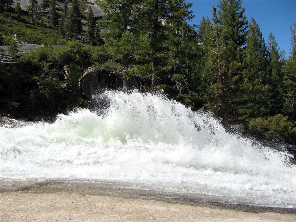
Waterwheel
Location: 37.7360877990723, -119.483932495117
Waterwheel on Merced Falls. This spectacular phenomenom constantly changes shape as the water rushes past and up and forms anything from arches to shark fins.
Merced Falls
Location: 37.7356910705566, -119.482025146484
This is the first real water feature you come to on the Merced River Trail heading up river from Nevada Falls.
Unamed Dome
Location: 37.7322044372559, -119.491889953613
This scene shows an unamed dome next to Moraine Dome with the the beautiful spring colors.
IMG_2732
Location: 37.7316780090332, -119.492942810059
Merced River Strings
Location: 37.7302322387695, -119.495635986328
Back Side of HalfDome
Location: 37.7348365783691, -119.505966186523
Perspective
Location: 37.735294342041, -119.484855651855
Merced Falls Closeup
Merced
Location: 37.7363471984863, -119.478538513184
Emerald Merced
Bunnell Cascade
Location: 37.7450294494629, -119.470718383789
ADVERTISEMENT
The end point of the Bunnell Cascades. The Merced rages pretty good here. Scattered wildflowers can be seen among the granite.
Lost Valley
Location: 37.7450294494629, -119.472160339355
Bunnell Cascades
Location: 37.7448310852051, -119.468681335449
More of the steep Cascades.
Footbridge
Location: 37.7444381713867, -119.460784912109
First of several footbridges across the Merced.
Niagra Cascade
Location: 37.7438468933106, -119.459800720215
Okay, I made this name up, but the cascade here looks a little like Niagra Falls.
Niagra of the Merced
Location: 37.7431869506836, -119.460060119629
Panorama of this section of the Merced
Bunnell Cascade Panoramic
Location: 37.7462120056152, -119.471046447754