Updated December 3, 2024 08:35PM
Best Hikes Ever: The Lost Coast Trail, CA
Hike a remote paradise just hours from California's bustling cities.
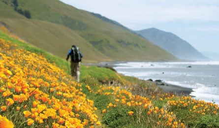
'Poppies color the Lost Coast. (Paige Falk)'

Our 2001 Editors’ Choice trip here was epic in every way. “We saw storm-driven swells that were running five to six feet above the normal highest tide along with horizontal rain that made walking difficult. Stream crossings got so tricky that some of us came within inches of being swept out to sea,” then-Editor-in-Chief Jonathan Dorn recalls. But for all that, he admits, it’s uniquely beautiful. “The Lost Coast might be the purest expression of solitude you can experience in the Lower 48, with sea breezes, mystical fogs, and cush campsites, to boot.” It’s also one of the wettest stretches of the Pacific Coast, averaging 100 inches of rain annually.
Do it The 53-mile route is divided into two sections. For the beach-hugging north, hike 25 miles from Mattole River to Shelter Cove (tide tables are a must for this section). To access the southern section’s 28 miles, start at Hidden Valley and head through Sinkyone Wilderness State Park. This segment penetrates groves of old-growth redwoods and tops 1,000-foot headlands with views of a coastline so rugged, the Pacific Coast Highway had to be diverted inland.
Info Lost Coast Trail
Shuttle Lost Coast Trail Transport (price varies, 707-986-9909) Permits North section (free, 707-986-5400; ca.blm.gov/Arcata); south section ($3 per person per night; parks.ca.gov)
Map California’s Lost Coast Recreation Map ($10, wildernesspress.com)