Published April 21, 2016 06:36PM
See Out-of-This-World Scenery at Craters of the Moon National Monument.
Explore the moonscape of Idaho—lava tubes, cinder cones, caves, and tunnels— on this weekend trip.
'Craters of the Moon (photo by Bergreen photography) | Bergreen Photography'
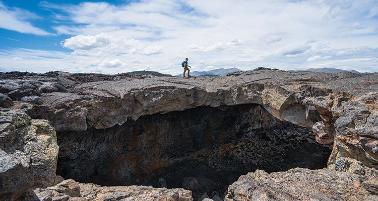
Descending into the ancient volcano feels like being swallowed by a monster. I set up camp in the mouth of the beast, surrounded by 200-foot cliffs—and am immediately overwhelmed with peace and quiet. But the tranquility in the crater bottom belies a violent past: Two-thousand years ago, molten rock gushed from these cracks in the earth, while ferocious explosions from thousand-foot-high cinder cones sent car-size boulders hurtling through the air. A quick foray from my campsite, 3.8 miles deep in Craters of the Moon National Monument, reveals evidence of this rocky past. Cylindrical cavities mark the spots where trees were entombed in flowing lava before rotting away, leaving their hollow forms in the hardened rock. Jagged chasms exist where ancient tunnels of lava formed and collapsed. A weekend of exploring these geologic wonders only fuels my curiosity—and ensures that I’ll be back soon.
Turn-by-Turn From the Tree Molds Trailhead
1. Head .1 mile east along the walkway.
2. Turn southeast (hiker’s right) and follow the Wilderness Trail 1.7 miles past the Buffalo Caves (explore with a free permit) to a .1-mile-long side trail leading to a cluster of lava tree molds.
3. Continue about 1.6 miles on the main path toward Echo Crater.
4. Veer .4 mile off-trail into the crater (it’s only accessible from the north end).
5. Head back to the Wilderness Trail.
6. Continue 1.8 miles to the Sentinel, a 5,812-foot cinder cone.
7. Head east off-trail through the open sagebrush prairie, tracing a lava flow, to a cluster of rock formations (marked with 8-foot-tall cairns) near mile 9.7. Highlight: the 25-foot-long Bridge of Tears, a tunnel that was named by an early explorer who hit his head on it.
8. Identify Echo Crater in the distance and loop back northwest through the Little Prairie to your camp at mile 14.6.
9. Retrace your steps to the trailhead.
Campsite: Echo Crater (mile 3.8)
The crater’s cliffs will shelter you from the winds that whip across the sagebrush steppe, while the rim provides an unmatched vantage point for catching the sunset over Idaho’s Great Rift. Pitch your tent below the rare limber pines for shade, and make it a basecamp. Since Echo Crater is near the apex of the lollipop loop, it’s ideally positioned for spending both nights (approximately miles 3.8 and 14.6, if you follow the writer’s route). Free permit required.
Water
Although USGS quadrangles show some blue, water is unreliable. Not convinced? The area’s first nonnative explorers documented “innumerable little bright red wrigglers” inhabiting the few puddles they found. Case closed: Pack it in (a gallon per person per day).
ADVERTISEMENT
Islands
There are four kipukas, or uplifts of land that were surrounded by lava flows, 1.5 miles northeast of Echo Crater. Since the flows protected them, their native plant community is largely preserved. Look for endemic whitish basalt milkvetch, purple Great Basin violet, and pink longleaf phlox (blooming April to June).
Hike It
Distance 18.3 miles (lollipop loop) Time 3 days Trailhead 43.428197, -113.548722; 24 miles southwest of Arco off Loop Rd. Season April to November Permits Required (free)