Updated July 7, 2025 05:41PM
Test Yourself in the "Grand Canyon of Pennsylvania"
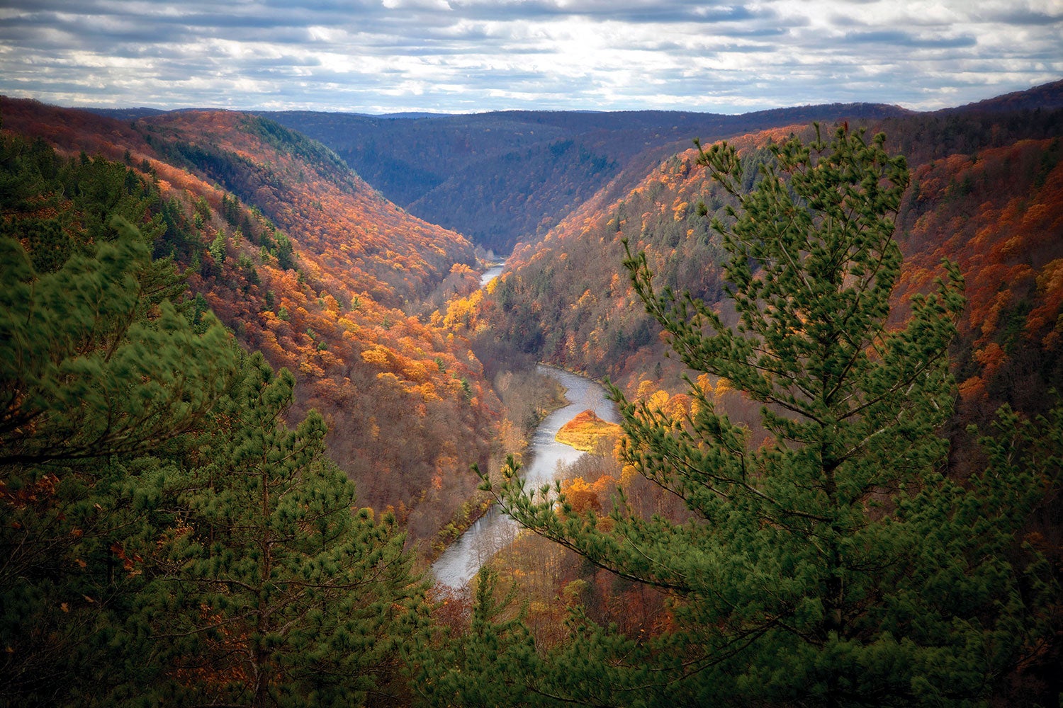
The climbs on the Black Forest Trail are serious—but then again, so is the scenery.
'Thom Lang / Alamy Stock'
I swear this trail is giving me amnesia. Over the last two hours or so, I felt the grind as I climbed yet another thousand feet out of a deep, steep gorge. But at the summit of Hemlock Mountain, my memory of the struggle is wiped totally clear: Pine Creek cuts into the forested, emerald hills, creating what locals call the Grand Canyon of Pennsylvania. I want to get lost in the view across the 400-foot-wide ravine, but I cannot linger. Up next is a thousand-foot descent followed by a 1,300-foot climb. Chances are good I’ll forget those hills as well. But I’ll always remember having this land of wilderness, waterfalls, and bubbling springs all to myself.
Turn-by-Turn from the Village of Slate Run
1) Note the orange blazes. The 42-mile Black Forest Trail is a long and winding route with connections to other nearby trail systems, but it’s well-marked.
2) Start by hiking north up a 1,200-foot ridge. After a few miles, give all the elevation back as the trail bottoms out at Slate Run (mile 6), a primo trout stream.
3) At mile 13, the trail crosses PA-44. After a long descent along County Line Branch, climb to the Barrens (mile 19), where stunted forest allows for downcanyon views.
4) Cross PA-44 again at mile 23.5, followed by a series of climbs and descents in and out of small tributaries of Pine Creek.
5) Optional: At mile 31 you can hike Naval Creek Run Road for about a mile to arrive back at Slate Run village if you want a shorter itinerary. Otherwise, most of the remaining 11 miles run along a plateau until mile 40, where you will take in the final views of Slate Run valley and descend.
ADVERTISEMENT
Campsites
Camping is allowed almost anywhere along the trail (usual LNT caveats notwithstanding), and you’ll likely encounter established sites every 2 miles or so. This creates an opportunity to take the trail at your own pace. Fancy moving water? Find sites with nearby waterfalls at miles 7, 15, 27, and 31. If views are more your thing (and you still want water), throw down at miles 10, 18, 24, and 36. You can’t go wrong, and the abundance means you won’t have to share.
Wildlife
This vast forest is home to a cast of creatures more commonly associated with the West, including black bears, bald eagles, and bobcats. In warm, sunny conditions, be wary of timber rattlers, especially on the final descent of a rocky ridge at mile 40. The many streams the trail crosses (including Slate Run) afford excellent angling opportunities, including a chance to catch (and release) native brook trout.
Towering Trees
The forests along Black Forest Trail were clear-cut for timber more than a century ago. However, one giant hemlock that avoided the sawmill (and the pests) still stands at the end of a.4-mile spur at mile 35.1. The impressive girth (4-foot diameter) and stature (about 120 feet) of this specimen offer a glimpse of what these forests once looked like.
ADVERTISEMENT
DO IT Trailhead Slate Run (41.4743, -77.5116); less than 2 miles uphill from the village of Slate Run across the creek from Pine Creek Road. Season Year-round; mid-September to mid-October is the best for fall foliage. Permit None, but a few ecologically sensitive spots along Slate Run ask you to self-register.