Updated December 3, 2024 05:37PM
These 10 Unlikely Leaf Hikes Will Make You See Fall in a Whole New Way
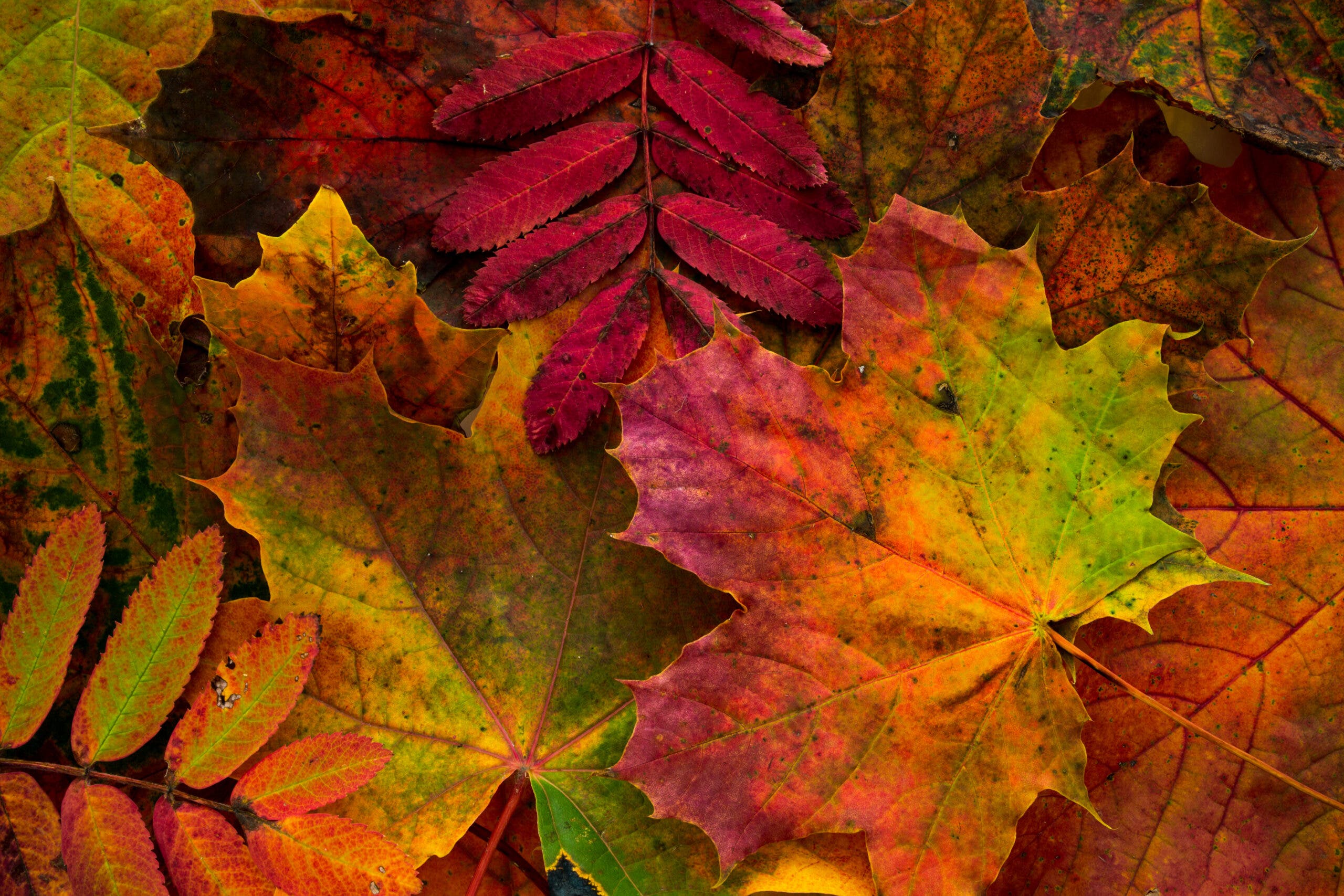
When most people think of fall colors, the first thing that comes to mind is leaves dropping from maples and aspens--but there's a whole rainbow to be found beyond that.
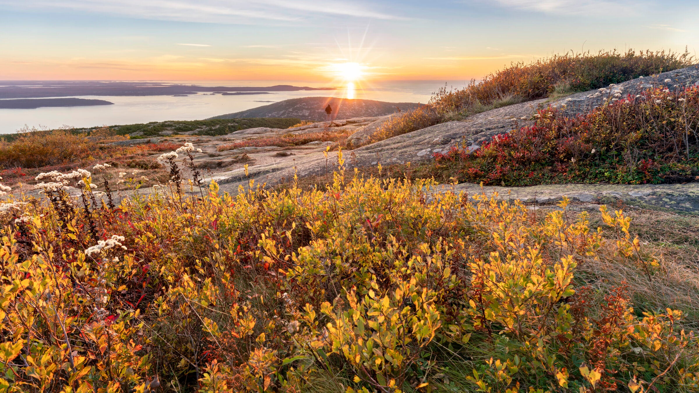
Sunrise from the top of Cadillac Mountain (Photo: Anand Goteti/Cavan via GettyImages)
Fall is a season of color–trees turning orange and gold, bright red apples, pale blue sky. But there’s a whole panoply of autumn hues that often gets ignored, hanging below the trees, spreading over rocks, and clinging to cliffside crevices. Check out these ten hikes to catch a little-known side of shoulder season hiking.
Mt. Major, Mt. Major State Forest, NH
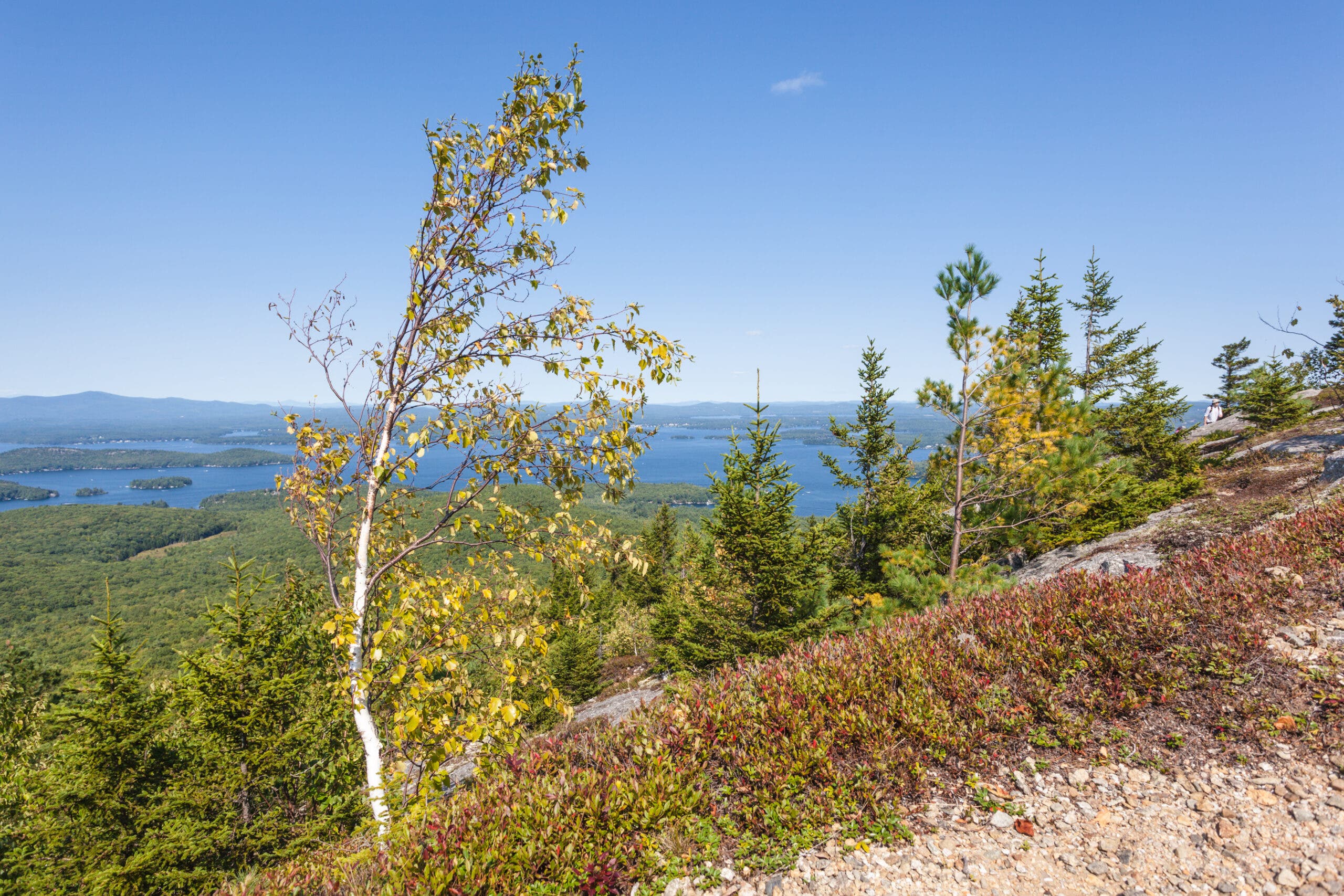
Wind rustles the evergreen slopes below the rocky summit of Mt. Major, high in New Hampshire’s White Mountains. Between the rocks, grasses, sedges, and shrubs flare bright yellow, orange, and deep red in a color show to equal any New England forest. Far below, the waters of Lake Winnipesaukee glitter among the trees, the lakeshore sharp even at a distance through the crisp fall air. At only 3 miles round-trip, this out-and-back isn’t long, but it takes you a whole world away.
September and October are peak color season on Mt. Major, between the last heat waves of summer and the first snow. You’ll want to bring along a camera and an extra memory card to capture both the changing leaves and the views. For an extra bonus—and amazing light—head up at sunrise, which conveniently comes later during the fall than the 4 AM dawns of summer.
Where Do Those Colors Come From?
During the sunny days of summer, deciduous plants use chlorophyll to convert the long hours of sunlight into energy, then into new plant mass. That chlorophyll is what gives leaves and grass their green color. In the fall, as the sunlight weakens and the days shorten, the chlorophyll breaks down. This lets other pigments usually masked by the chlorophyll, like yellow and orange carotenes and xanthophyll, come forward. Other chemical changes in the leaves create new pigments, like those that turn dogwoods and sumacs purple and sugar maples deep red. As the leaves change, the tree also seals off the scar behind the stem, so that when the leaf falls under its own weight it doesn’t leave a wound on the branch.
ADVERTISEMENT
The Trail
Start from the Mt. Major Parking Area and take the Boulder Loop Trail from the southwest edge. At the first intersection, head right, going south through the forest. (Make sure you’re on the orange-blazed trail.) Turn westward and head uphill, then reach a stretch of rocky ledges just before the summit. From the top, pause to take in the views of the White Mountains and Lake Winnipesaukee, then retrace your steps back to the parking lot.
ADVERTISEMENT
Maah Daah Hey Trail, Little Missouri National Grassland, ND
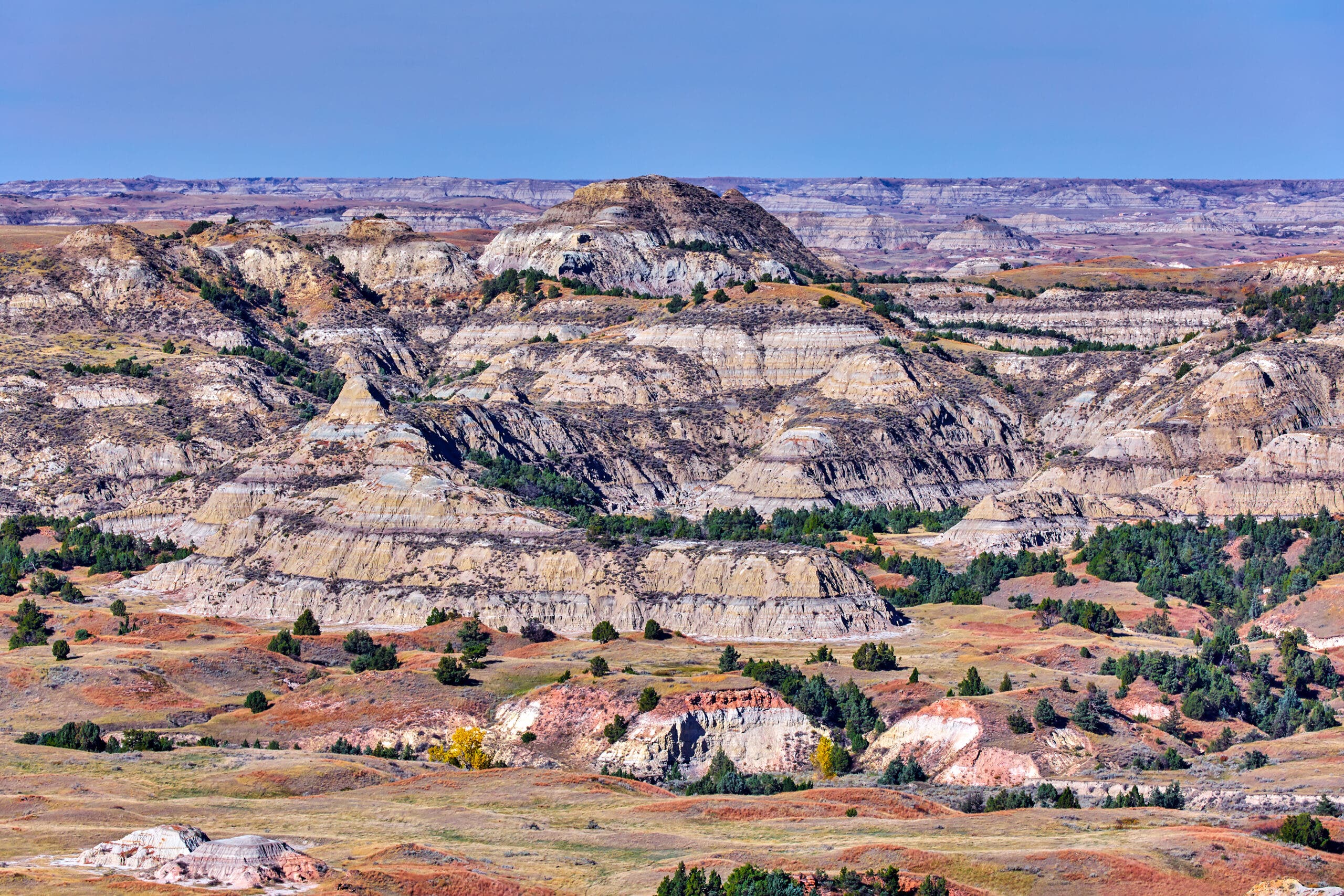
Winding 144 miles through the badlands of Little Missouri National Grassland to connect the two units of Theodore Roosevelt National Park, the Maah Daah Hey Trail has become a favorite challenge for bikepackers. But don’t write it off: Exploring the stark mixed-grass prairies and shrublands here is as rewarding on foot as it is on two wheels. From soaring sedimentary bluffs to grasslands carpeted with big bluestem and wheatgrass, this is a landscape that will etch itself into your memory.Bonus: Unlike more popular national forests, you won’t find yourself dealing with crowds here. Neighboring Teddy Roosevelt National Park receives a scant 600,000 visitors per year, and the open country between its units gets even less.
How did the Badlands Form?
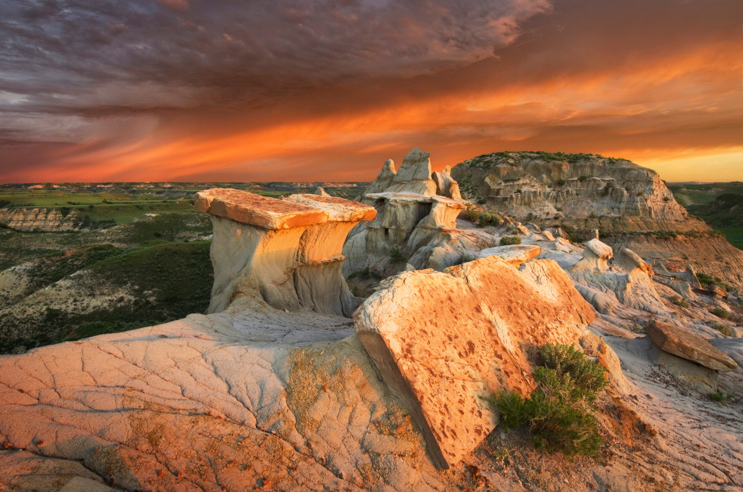
The first layers of the rocks that now make up the Badlands were laid down 75 million years ago. Limestone deposited in shallow seas, sandstones, and shales from long-gone riverbeds, and even volcanic ash built up a thick set of rock formations. Then, a half-million years ago, the Cheyenne and White Rivers began carving their way through what is now the Badlands, forming the characteristic narrow canyons and peaks. The soft sedimentary rocks of the region are still eroding, at the geologically lightning-fast rate of an inch per year.
The Trail
From Sully Creek State Park, just south of Medora, hike north through native mixed grass, watching for bighorn sheep on the buttes. Camp in four established sites (18 miles apart) with vault toilets and potable water. Alternatively, plan to haul water or cache at campsites near road crossings. More highlights: Glimpse the northern lights (early winter), bison, and feral horses.
ADVERTISEMENT
Raven Cliff Falls, Chatahoochee National Forest, GA
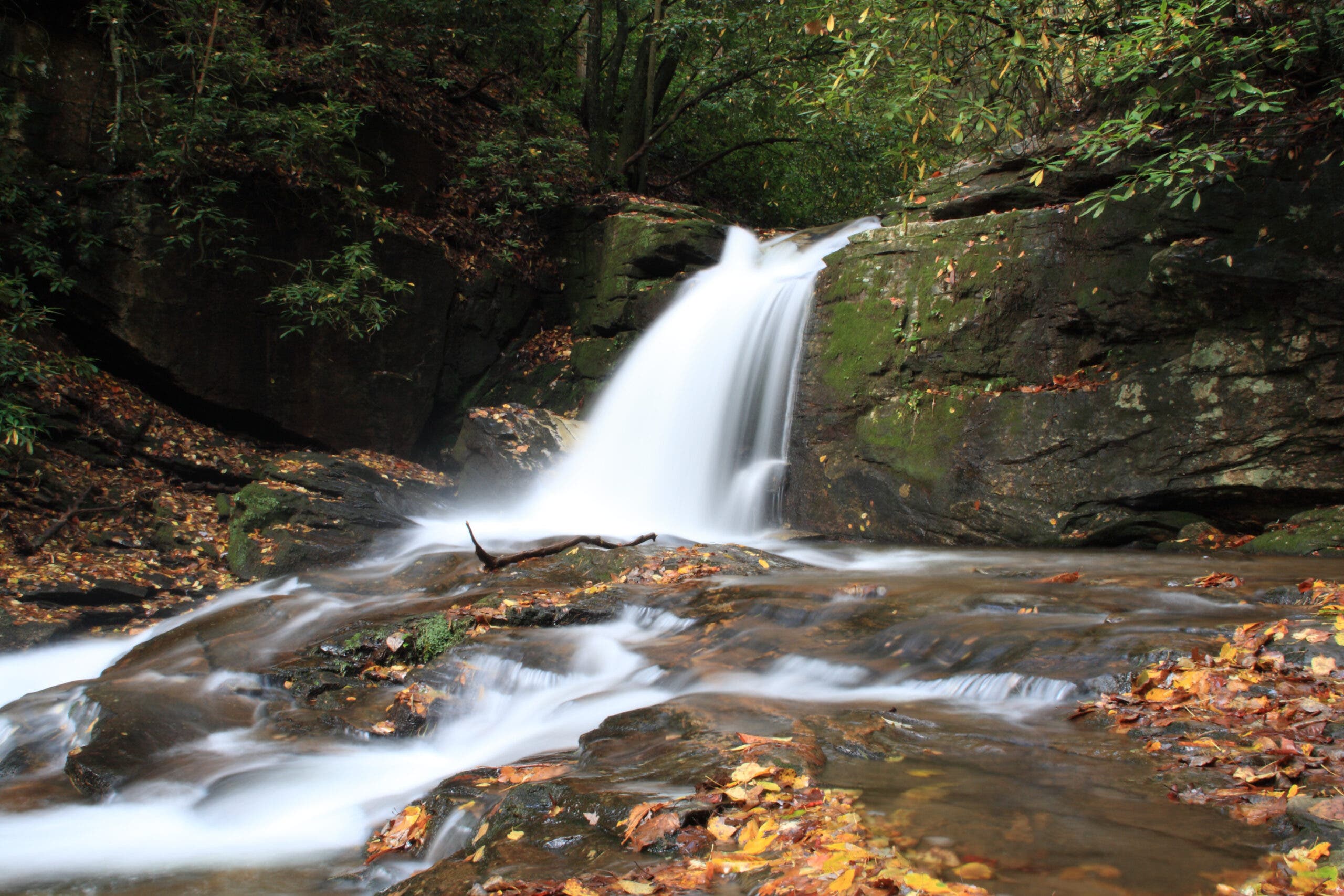
This hike crams several waterfalls into 4.9 miles, culminating in a 40-foot cascade gushing from a deep split in a cliff. Though the surrounding forest is mostly hemlock and pine, there is one incredibly bright source of fall color: American bittersweet. The woody vines spiral up the trees to 20 feet above the ground, and every fall their berries turn bright orange. Between the berries, wrens and chickadees—or, in the early morning and late evening, red bats and pipistrelles—glide between the trees. Once the weather turns, this popular trail quickly loses crowds, leaving no sound but the rush of the falls and the babble of the creek for hikers willing to don a few extra layers (and maybe brave some mud).
There’s more color here than just the bittersweet, though. As the trail winds beside a trout-filled brook, crossing several times between the waterfalls, you might notice another bit of vibrancy at your feet–moss so green it seems to fluoresce. The damp creekside creates perfect conditions for a forest floor that’s more moss than shrubbery, and supports several species of amphibians. Not content with just a day wandering these woods? There are several campsites at the trailhead, perfectly within earshot of the rapids of the creek.
Name that Moss
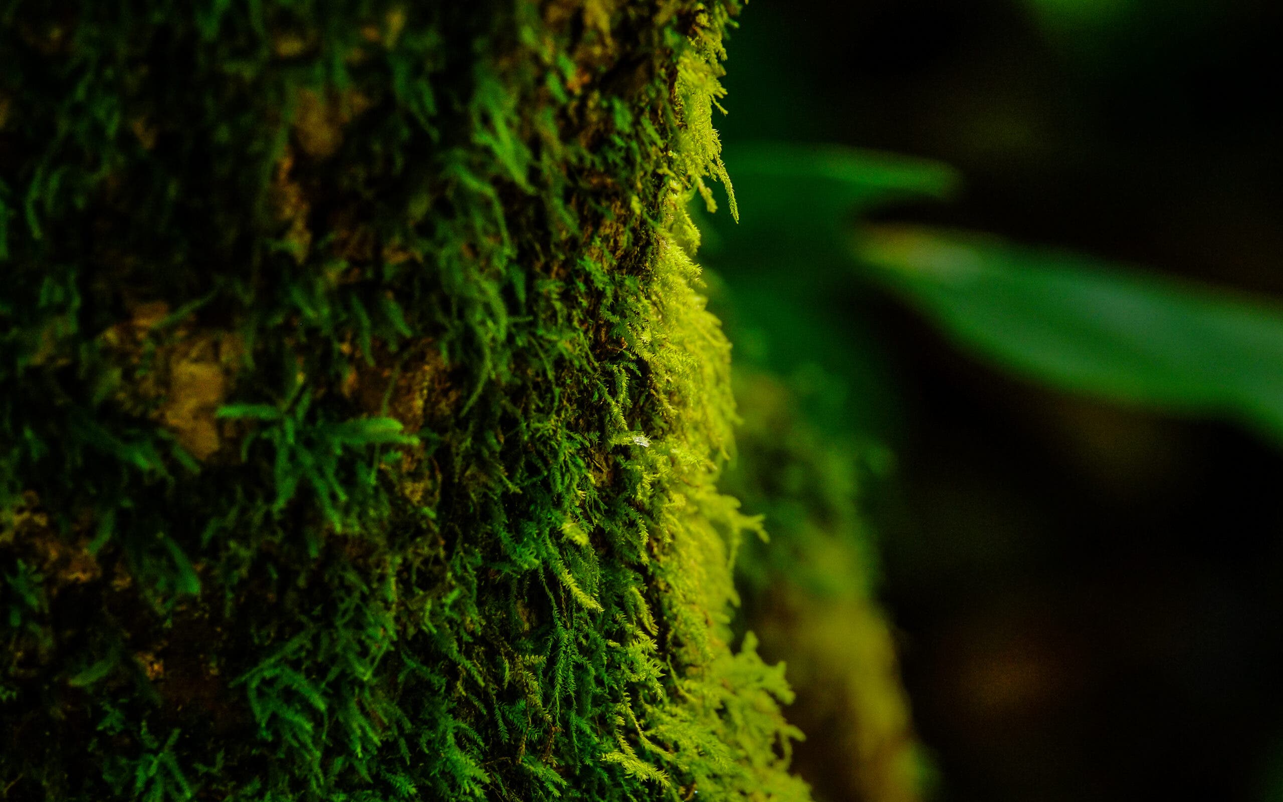
There are more than 12,000 species of moss, growing all over the world just about anywhere but salt water. They help keep soil in place, preventing runaway erosion, and also break down exposed rocks, which frees up nutrients for other plants. Mosses can be traced back nearly 300 million years. They reproduce through spores, the housings of which constitute the main difference between species, and also by regenerating from small fragments or by branching off and establishing another plant in a new spot. Several plants referred to as mosses actually aren’t; beard moss, oak moss, and reindeer moss are lichens, Irish moss is an algae, and Spanish moss is an air plant in the same family as pineapples.Keep an eye out at Raven Cliff Falls for fern moss, which–true to its name–looks like tiny ferns.
ADVERTISEMENT
The Trail
From the Raven Cliff Parking lot, follow the Raven Cliff Trail through a thick hemlock grove. At the three-way intersection, go straight, passing a campsite on the right. Cross Dodd Creek on a wooden bridge, listening for the sound of swift water ahead, before reaching the creek’s first set of rapids. Cross several more bridges over the creek, passing the first few falls and a couple creekside campsites, then head up a low ridge covered with ferns. Drop back to the creek, then head right at a Y-junction and into the cliffs. Listen for the croaking calls of the namesake ravens. Continue climbing steeply towards the cliff face to reach the final waterfall, gushing from a crack in the rocks. Retrace your steps to the trailhead.
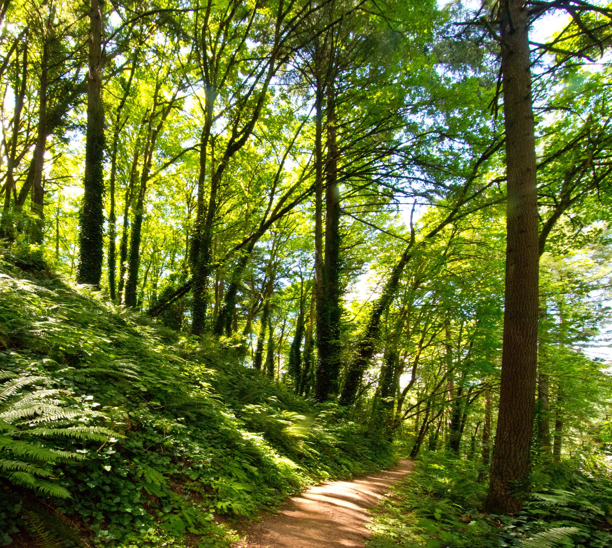
Dogwood Trail, Forest Park, OR
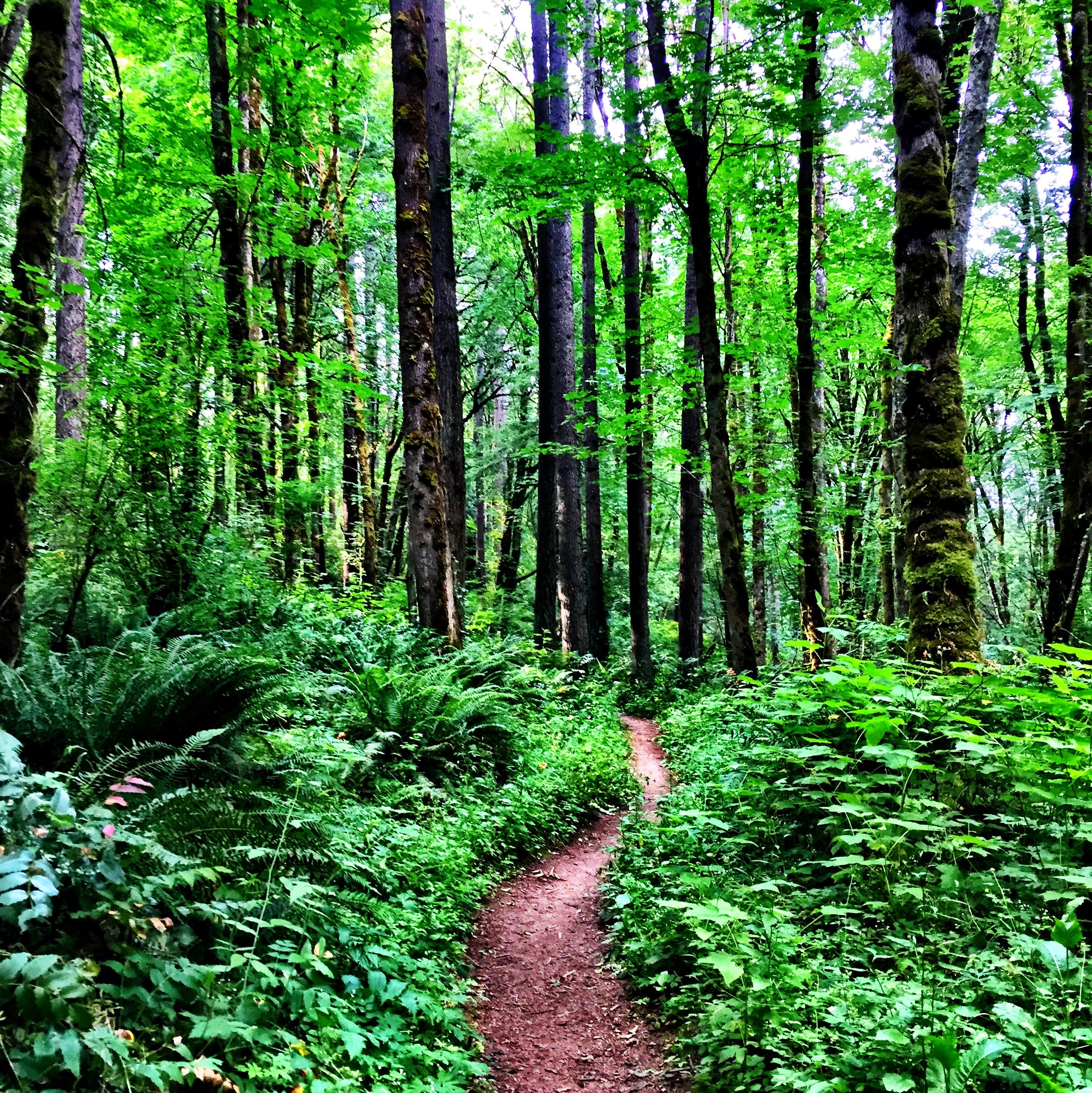
The largest urban woodland in the country is mostly evergreen, but there’s still plenty of fall color if you know where to look. 70 miles of trail wind through 5,000 acres of second-growth forest along the slopes of the Tualatin Hills in Portland, Oregon; and among those 70 miles of trail, every fall, the 2.6 mile loop of the Dogwood Trail adds a shock of color to the Pacific Northwest rainforest. The namesake dogwoods, crowding the banks of a stream and the hollows beneath the firs, hemlocks and cedars, don’t have the brightest leaves, but their stems and branches turn a startlingly intense red every autumn.
Forest Park tends to be busy; Portland is a big city, after all, and full of hikers, runners, and cyclists who crave a close-to-home nature fix before, after, and during the work day. But once you get deep into the woods, even with plenty of human companions on trail, this city park feels indisputably wild. Squirrels, chickadees, and deer nose among the bright dogwoods, elk are occasionally spotted between the firs, and the thick cocoon of foliage blocks out even the sound of traffic. Take a deep breath of the rain-misted fall air, pull up the hood of your hardshell, and go search out some color in these woods.
ADVERTISEMENT
The Birth of a Park
The idea of keeping the forested uplands that now form Forest Park protected was first proposed in 1903, by the sons of the man who designed Central Park in New York City. It took years for the idea to be acted upon, though, and the area was nearly developed several times in the intervening times. Luckily, the damp hill slopes were not very suitable for building, and the forest escaped a residential fate until it was finally protected and dedicated in 1948. Today the park continues to provide refuge for both wildlife and humans, as well as filtering out toxins from the city air and water.
The Trail
There are three different trailheads with easy access to the Dogwood Trail. From the trailhead just before mile marker 1 on Leif Erikson drive, go straight. At the three-way junction with the Wildwood Trail, continue straight again. At the Y-junction, go right, then take a left on the Wildwood Trail to close the loop. From the northernmost trailhead on NW 53rd drive, go right on the Dogwood Trail. Take a left at the Y-junction. When you reach the Wildwood Trail, go left to return to the parking lot. From the next-northernmost trailhead on NW 53rd drive, go left, then right at the y-junction.Turn right when you reach the Wildwood Trail. At the junction with the Wild Cherry Trail, go right to return to the trailhead.
ADVERTISEMENT
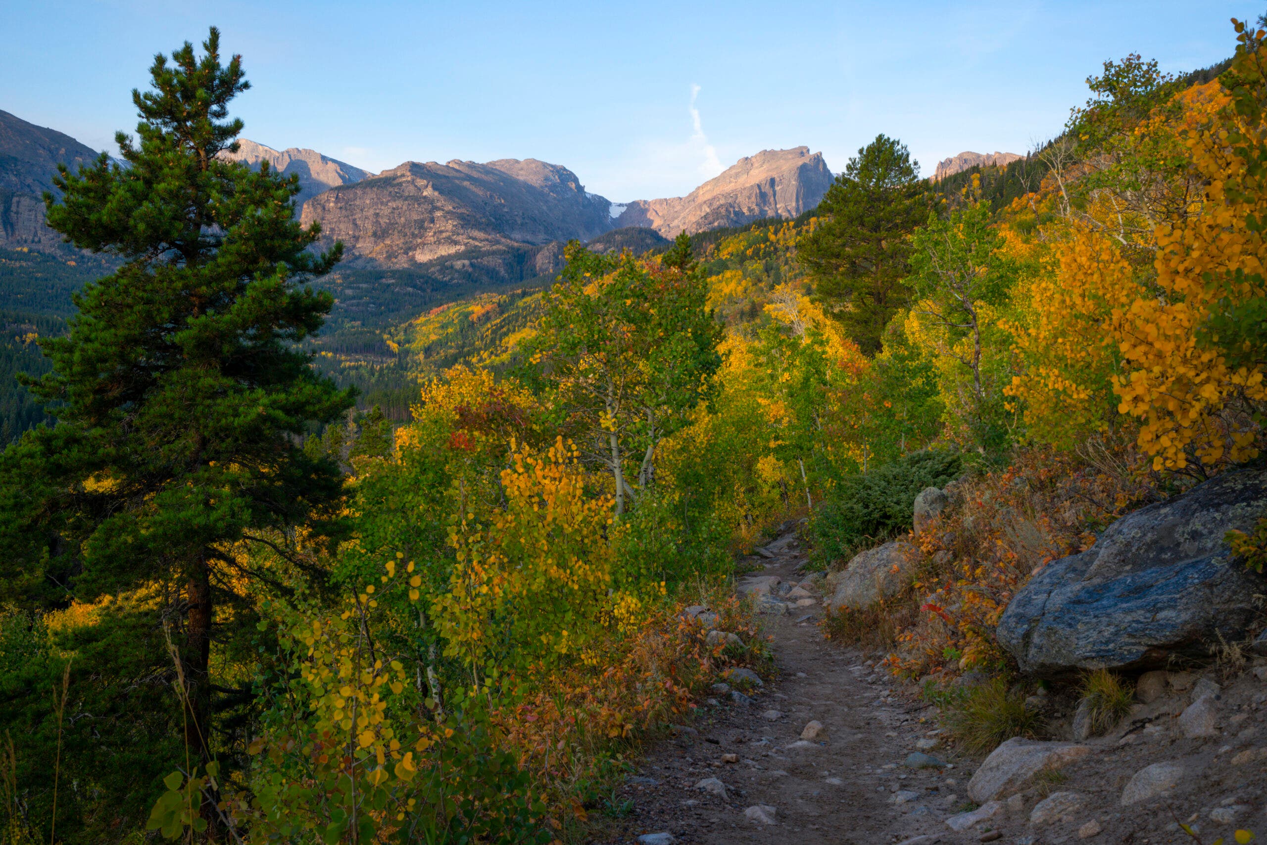
Flattop Mountain, Rocky Mountain National Park, CO
When most people think of fall in the Colorado Rockies, they think aspens, all pale gold leaves and white trunks. There’s a lot more to the season than just one tree, though. On the 8,1-mile out-and-back climb of Flattop Mountain, check out some color closer to the ground. Most of the hike is above treeline, which means there won’t be any distractions from the show at your feet-—bright red kinickinnick. Also known as bearberry, kinickinnick doesn’t grow more than a foot high, and thrives in any well-drained soil, even sand, so the rocky slopes of Rocky Mountain National Park are a paradise for it. As you can probably guess from the alternate name, its berries—also bright red in the fall—are a favorite of bears fattening up for the winter, so keep an eye out for black bears heading up the slopes with you.
There’s more to this hike than just cool plants, though. Viewpoints before and just after the trail clears the treeline offer tantalizing glimpses into the mountainous heart of the park, and once you start the long, exposed climb to the summit, the glimpses give way to full-time vistas. After winding past views of Dream Lake and Emerald Lake, the summit opens up a panorama of the Mummy Range, Longs Peak, Glacier Gorge, and Tyndall Glacier.
How does Hibernation Work?
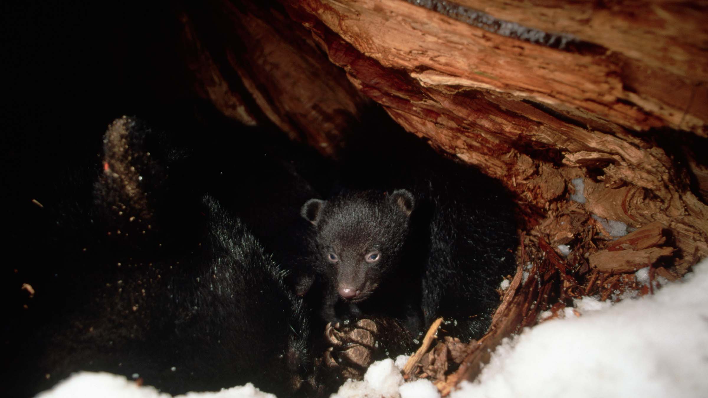
Bears—along with marmots, their fellow mountain-dwellers—spend the cold months of the year snug in their dens, sleeping the time away. But what actually happens when the bears go into hibernation? To start, they lower their body temperature by 8-12 degrees, lowering the amount of energy they need to expend. They don’t need to eat or drink, instead breaking down the fat stores they built up over the summer and fall. They also rarely, or never, go to the bathroom. They do move around, though, to prevent pressure sores from forming—or, for many females, to give birth to cubs. The entire process is an adaptation to winter food scarcity, when the bears have little chance of finding enough forage to sustain them. Hibernation allows them to sleep the time away until the plants and prey return in the spring.
ADVERTISEMENT
The Trail
From Bear Lake, this 8.1-mile out-and-back begins by heading northwest on the Flattop Mountain Trail. The methodical upward climb—over 2,800 feet in 4 miles—begins almost immediately and traverses rich conifer forests intermixed with aspen. At mile 1.6, catch your breath at the impressive view of Dream Lake’s shimmering surface, backdropped by rugged mountains. From the overlook, continue upward on the tight, switchbacking trail.
Just before breaking treeline, the trail passes another overlook above Emerald Lake. Stop for views of Glacier Gorge and Longs Peak that open up to the southeast. Look southwest toward Hallett Peak, and pick out the level profile of Flattop Mountain by following Tyndall Gorge’s contour to the west. The remaining 1.3 miles are a long, slow grind up Flattop Mountain’s high-alpine eastern slope. During the winter or if the trail is dusted with snow, follow large rock cairns leading to the mountain’s north side.
Just before summiting, (the trail junction on the indistinct peak is generally considered the highpoint), you’ll pass a hitch rack at the top of Tyndall Glacier. If peak-bagging is your goal, consider adding 1 mile with an out-and-back to Hallett Peak.–Mapped by Tim Shisler and Jenn Fields
ADVERTISEMENT
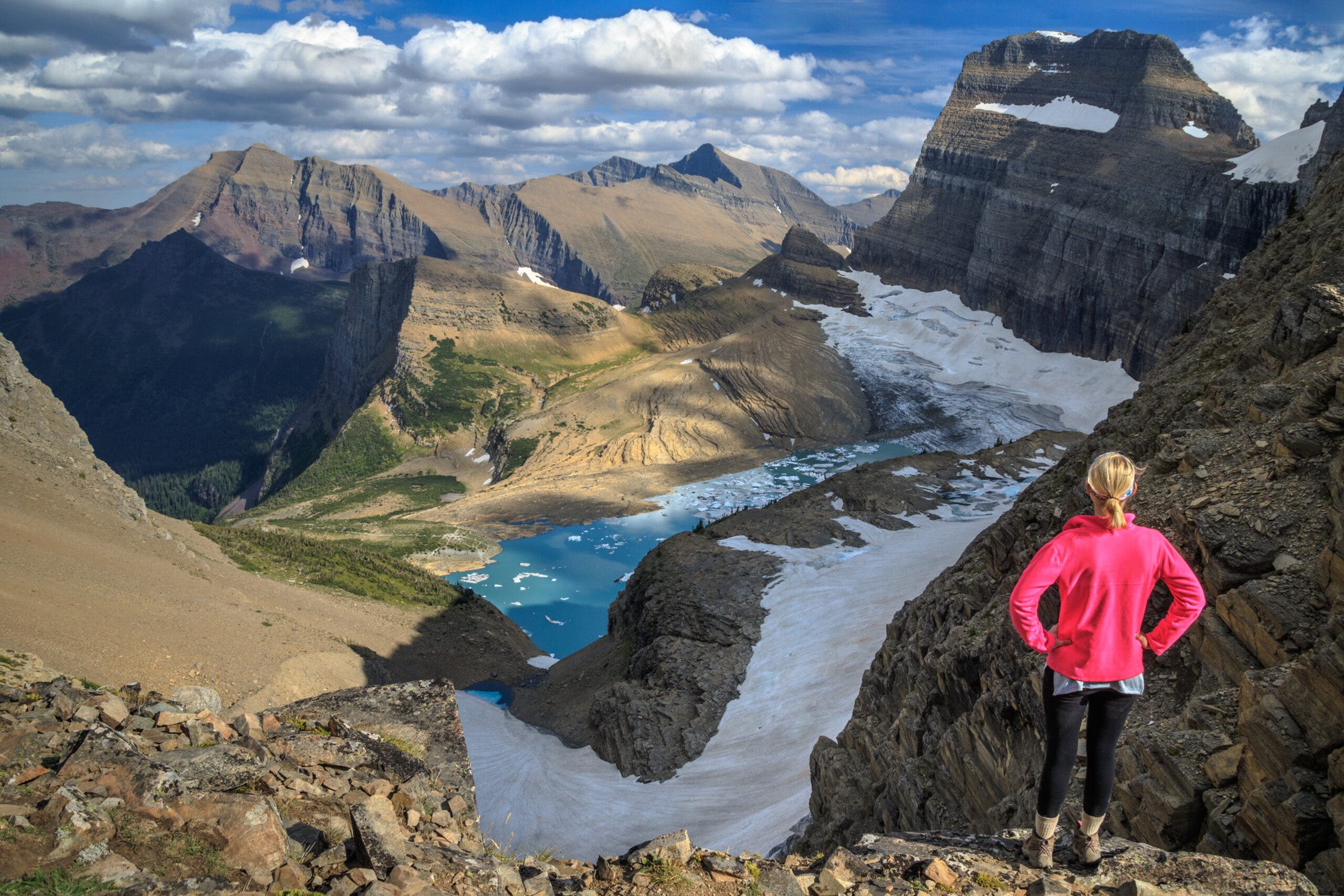
Redrock Lake, Glacier National Park, MT
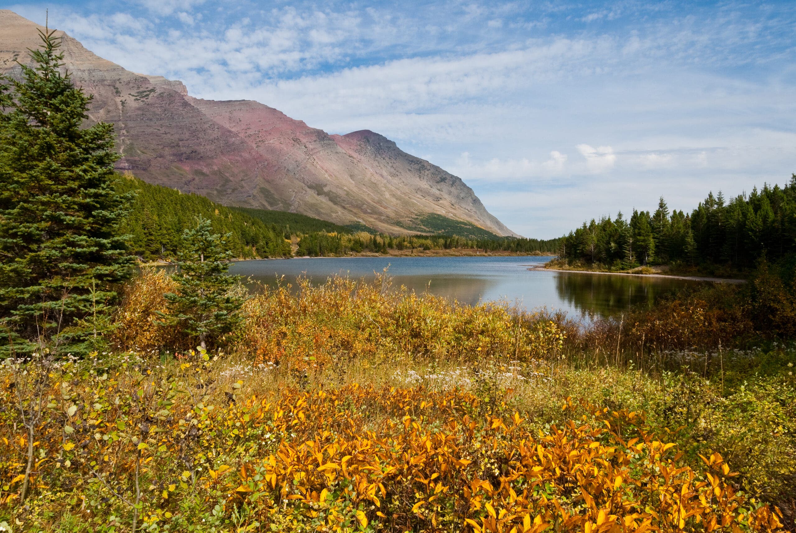
It isn’t just the colors that are the fall draw on this hike—that autumn rainbow is courtesy of blueberry and huckleberry bushes crowding the banks of the lake, and they bear a tasty load. Between snacking, take in views of the continental divide, Mt. Wilbur, and Mt. Grinnell. At only 4.2 miles round-trip, it’s a hike the whole family can enjoy, though you might end up fighting for the best berry bushes. With only 285 feet of elevation gain it isn’t nearly the strenuous climb of many of Glacier’s other hikes, either.
Tucked away in Many Glacier Valley, Redrock Lake‚and its fall burst of deep red foliage, courtesy of the berry bushes—isn’t just a favorite haunt of the park’s human visitors; bears enjoy the fall smorgasbord, too. The berries provide a good source of food in the final weeks of their annual pre-hibernation bulk-up, and there are brook trout in the water, too. On the way up, don’t miss Redrock Falls, a brief but steep cascade over glacier-carved rocks a few shades darker than the leaves to either side of the trail. Bonus: An early section of the trail passes through a stand of aspens, which turn bright gold every fall.
Where are the Glaciers of Glacier National Park?
Like many other glaciers across the country and the world, the namesake glaciers of Glacier National Park are shrinking as climate change accelerates. Most of the glaciers in the park have always been small, mainly alpine cirque glaciers clinging to the peaks along the Continental Divide. As the planet warms, these rivers of ice have gotten even smaller. The latest models, from an effort led by UNESCO, predict that the park will have no glaciers left by 2100 if greenhouse gas emissions aren’t lowered. Because they’re so small, the glaciers of glacier are particularly vulnerable–they have a large surface area to mass ratio, leaving much of the ice exposed to sun and heat, and even a small amount of melt can vanish a significant percentage of the glacier.
ADVERTISEMENT
The Trail
Start from the Swiftcurrent Pass parking lot. Follow the Swiftcurrent Pass Trail west through a stand of aspens and lodgepole pines. At the first intersection, stay straight, passing Fishercap Lake to the left. Swing southwest into an ice-carved cirque, crossing a stream half a mile later. At mile 2.1, reach the grassy banks of Redrock Lake, dotted with berry bushes and dwarf conifers.
Two-Section Trail, Tallgrass National Prairie Preserve, KS
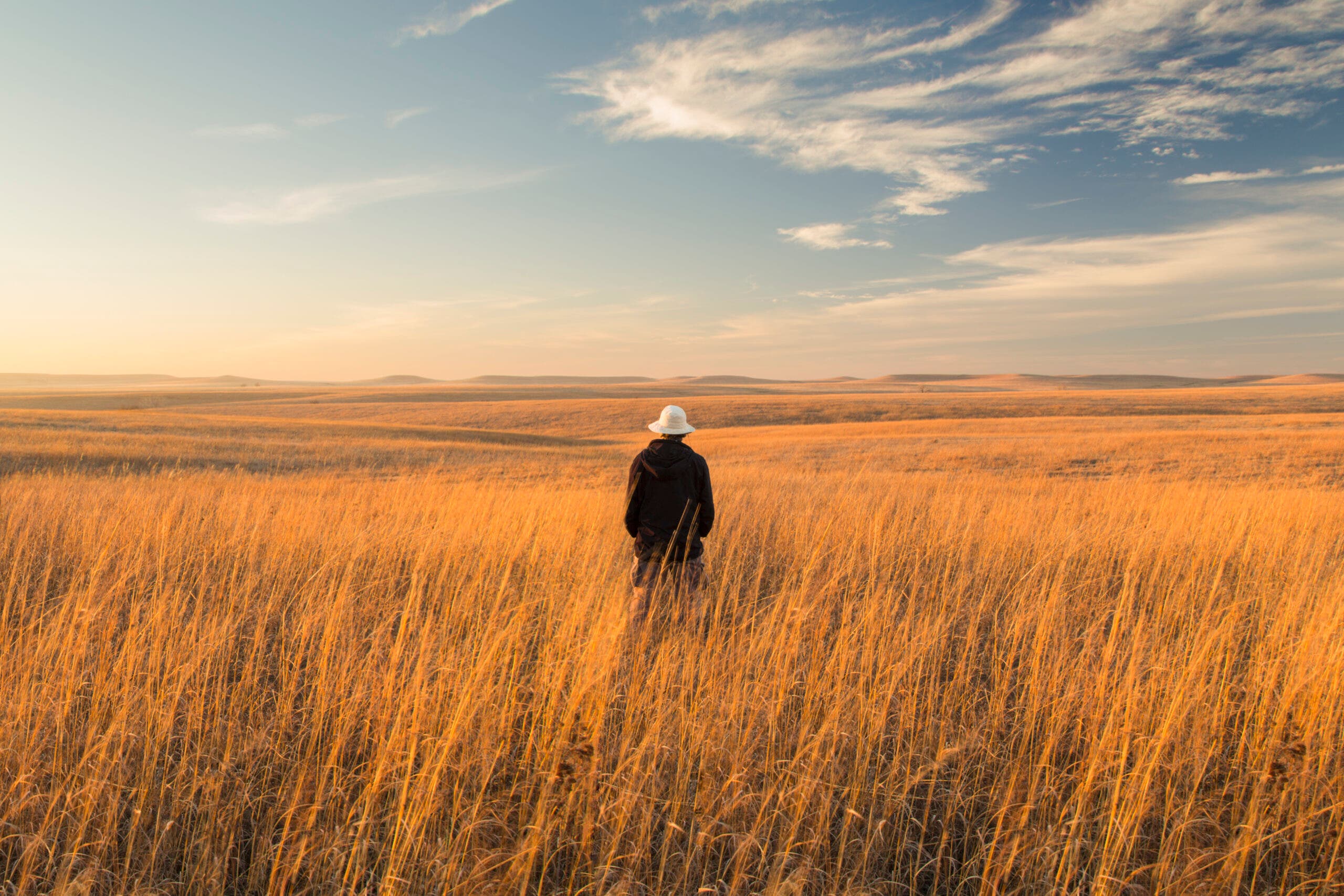
It’s not often you hear about Kansas as a leaf-peeping destination, since the state has few trees, and therefore few leaves, that turn colors in the fall. The prairie more than makes up for that, though, with its own incredible color show. The switchgrasses, a native prairie plant that covers much of Tallgrass National Prairie Preserve, turn as brilliantly red and gold as any maple every fall, leaving hikers with the feeling of wading through a windswept sunset. On this 6.2 mile out-and-back, head into the heart of one of the few remaining pieces of the American heartland’s once-extensive tallgrass prairie for an autumn rainbow like you’ve never seen before.
Of the miles of trails in this National Prairie Preserve, the Two-Section Trail might be the best for switchgrass, the most colorful of the autumn prairie plants. The gentle waves of grass seem to run out endlessly in every direction, meeting the pale blue autumn sky at every horizon. Narrow stands of trees huddle close to the water in hidden creek-bottoms, but these are only rare cracks in the vista—the rest is just red and gold, grass and sky, as far as the eye can see.
ADVERTISEMENT
Tallgrass Prairie Ecosystem

One of the rarest and most complex ecosystems in the world, tallgrass prairie is an ecological treasure. Before European settlement and farming, these prairies covered 170 million acres of North America; today barely 4% of that historic range remains intact. What was once the continent’s largest contiguous ecosystem, stretching from the Rockies across the Mississippi and from Saskatchewan to Texas, now exists only in scattered fragments.
The diversity and complexity of tallgrass prairie is surpassed by only one other ecosystem, the Brazilian rainforest. Eighty percent of the plants in the tallgrass prairie are grasses, with 40 to 60 individual species found in any stretch of prairie. Little and big bluestem are common, as is wild rye. The rest of the plant life consists of over 300 distinct species of flowers and forbs. Below the grasses and flowers, over 100 species of lichens and liverworts crowd the ground. The vast variety in soil type and depth, moisture content, and slope across the prairies resulted in the development of dozens of distinct niche ecological communities, from bottomland prairies to sandy near-desert soil. The main stems of the prairie plants—and three quarters of the prairie’s biomass—are underground, where they are protected from scouring winds, extreme cold and heat, and fire.
The Trail
From the Two-Section trailhead on west 9th street, head north into the grass. Pass a small pond before gradually turning east, heading deeper into the preserve. Ascend a gentle hill before passing two more ponds, surrounding by brightly colored switchgrass. Head slightly downhill before reaching the border of the preserve and the end of the trail at mile 3.1, then retrace your steps to the parking lot.
ADVERTISEMENT
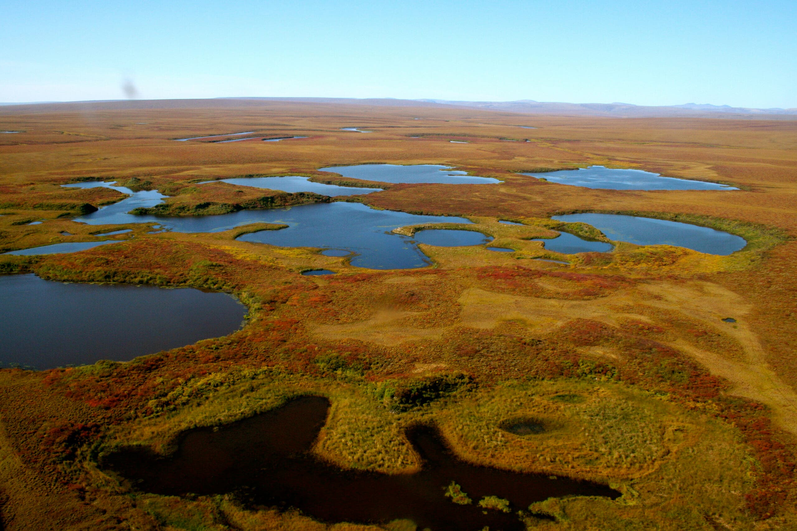
Kuzitrin Lake, Bering Land Bridge National Park Preserve, AK
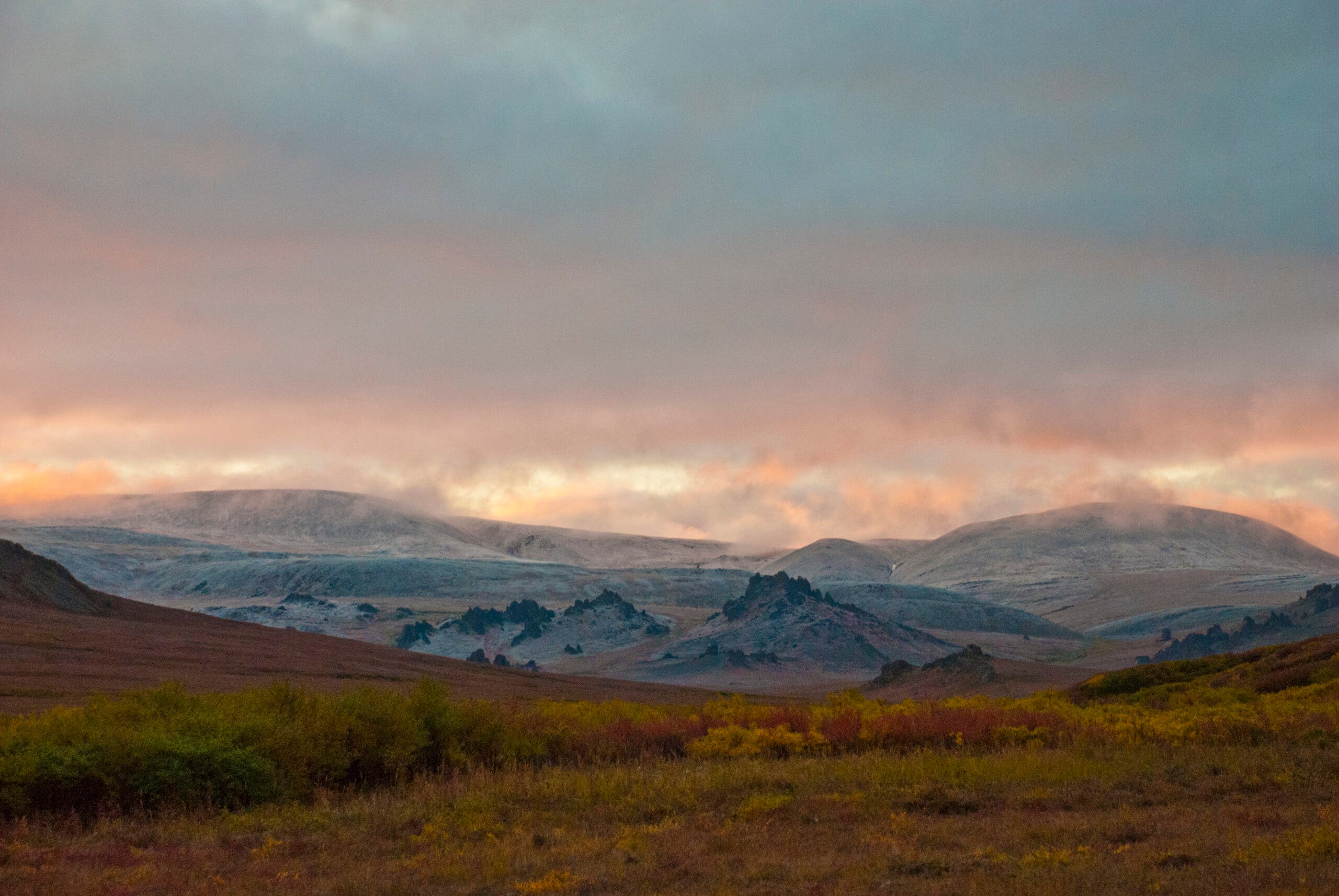
No crowds here: The only way to get to this colorful autumn stretch of tundra is backpacking. The hummocky tundra covering one of the country’s most remote national parks is usually a smattering of greens, from pale lime to deep veridian, but for a few short weeks every fall it turns to bright crimson and gold. Catch the show on the 55-mile hike up the Kuzitrin River to Kuzitrin Lake (or, if time is short and funds are deep, take a bush plane to one of the larger lakes nearby and hike in from there). Caribou, musk oxen, and Arctic fox are your most likely neighbors on this trip; the foxes will be shedding their brown summer fur for white winter camouflage, making them easy to spot against the bright fall colors of the tundra plants. Closer to the coast, walruses, ribbon seals, and polar bears stalk through the preserve. There are brown bears here too, feasting on the shrubby plant life and the herbivores that thrive on it, so make sure your food is kept somewhere secure. Listening for birdsong from your tent? The low, eerie wail of the yellow-billed loon is likely to drift from Kuzitrin Lake, as this iconic Arctic bird prefers inland waters for fishing. On the nearby shore you might hear the rustle and guttural trill of willow ptarmigan picking through the foliage for seeds.
Volcanoes!
The flat landscape of Bering Land Bridge National Park is broken up by two distinct sets of volcanic formations—the Imuruk Lava Field and the Devil Mountain Lava Field. The Imuruk Lava Field, in the southeast section of the park, is made up of about 75 volcanic vents and 900 square miles of lava flows, in overlapping layers from older to newer eruptions. The oldest layer, called the Kugruk Volcanics, formed between 28 and 26 million years ago, while the newest layer—the Lost Jim Lava Flow—formed only 1,000 to 2,000 years ago. The Lost Jim Lava is mostly pahoehoe lava, which is basaltic lava that twists in ropelike strands now preserved as rock. The Devil Mountain Lava Field, on the Seward Coastal Plain in the central northern part of the preserve, covers about 400 square miles. One of the most notable features of this field are five small shield volcanoes (named for their shape, these volcanoes have low-angled sides and form from basaltic lava, the least explosive type). Another is four maars, lakes that formed from explosions made by interacting ice and magma. The oldest of these maars, Whitefish Lake, is between 100,000 and 200,000 years old, and 2.5 miles wide; its depths has never actually been measured.
The Trail
There aren’t any marked trails in Bering Land Bridge National Park, so good maps, a compass, and orienteering skills are a must; a GPS unit comes in handy, too. From the end of the dirt road at Kougarok, follow the Kuzitrin River all the way to Kuzitrin Lake, a distance of about 55 miles over hummocky tundra.
ADVERTISEMENT
Taskinas Trail, York River State Park, VA
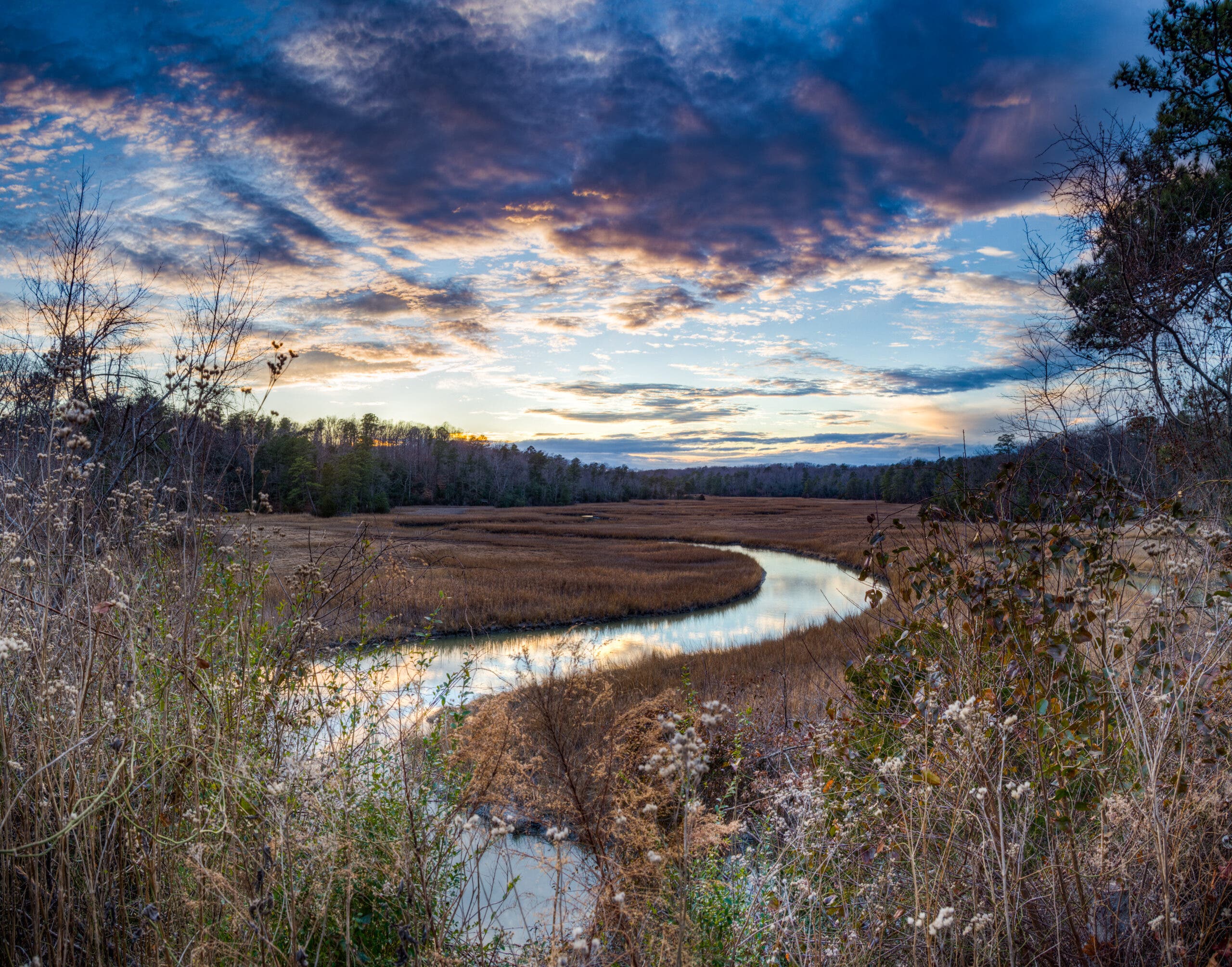
The Taskinas Trail weaves a 2.9-mile lollipop loop around a tributary of Virginia‘s York River, dropping through wetlands and woods. There’s plenty to see here in every season, with fossil beds, archaeological artifacts, and an estuary ecosystem that supports an incredible array of plant and animal life, but fall marks the best season of one particular plant: American beauty berry. This understory shrub, usually only 3-5 feet in height, produces iridescent purple berries every fall. Apart from their colorful allure, these berries are an important part of the ecosystem. During the fall and winter, as food becomes more scarce and the weather gets colder, many of the park’s birds rely on the beautyberry as an important food source. The northern bobwhite, a ground-dwelling bird sometimes known as a Virginia quail and classified as near-threatened (the population is dropping but not yet dangerously low), is particularly reliant on the beautyberry.
Four observation platforms along the trail give hikers a chance to spot two other bird species. Ospreys and great blue herons can often be seen fishing in Taskinas Creek Marsh and the creek itself. As the leaves drop away in fall these birds get even easier to spot, making this trail a great choice for birdwatchers.
What is an Estuary?
An estuarine ecosystem is one located where a freshwater source, like a river or stream, meets the ocean. The shifting tides mix fresh and saltwater together, creating a unique environment that supports a wide variety of species across the entire spectrum—freshwater, saltwater, and mixed. They produce twenty times more plant matter than open ocean, and are one of the most productive ecosystems on earth. The shallow water that forms a large part of most estuaries offers easy access to food for birds, mammals, and fish, and wildlife comes from both the ocean and inland to feed there. As a sheltered environment connected to both rivers and the open sea, these unique ecosystems are important as breeding and nursery grounds for a wide variety of species whose young are not resilient enough for the buffeting waves and currents out in the ocean.
ADVERTISEMENT
The Trail
Start from the horse trailer parking lot just south of the visitor center. Follow the tomato-red blazes through woods and then marsh, weaving between the two environments as the trail dips in and out of small valleys. A spur trail partway through leads to a platform in the middle of Taskinas Creek Marsh, where hikers can watch for paddlers going by as well as fishing ospreys and herons.
Cadillac Mountain, Acadia National Park, ME
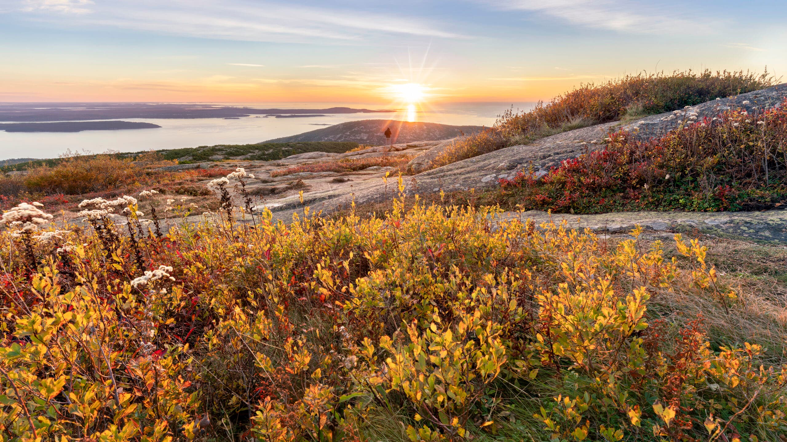
The scent of salt drifts up with clouds of spray far below, carrying far through the clear autumn air. From the rocky summit of Cadillac Mountain, it seems all of Acadia is laid out before you; a scattering of islands beyond the shore, high peaks inland, and the Atlantic, rolling in long sheets of blue-gray to the brighter blue sky at the horizon. Though the surrounding vista is dominated by blue sea and sky, gray rock, and dark green evergreens, at your feet and to either side of the trail is all bright fall colors: deep red woodbine, alder, and bearberry sprawl over the granite ledges of the mountainside and fill the understory with crimson and scarlet.
The 3.5 mile-climb isn’t easy, but the top is more than worth it, a spot of color with all the world of wild Maine laid out below. For an even more incredible summit experience—and easy-to-find early morning parking spots—get up in time to catch the sunrise, hiking up in the dark to reach the summit just as dawn spills gold, rose and lavender over the spumy waves of the Atlantic coast.
ADVERTISEMENT
Raptors on the Move

Cadillac Mountain is one of the best places in the park to catch the annual raptor migration, when a dozen different species of hawks head south for the winter. The park’s official Hawkwatch tallies them from lookouts on the mountain, but you don’t have to be part of the official count to get caught up in the spectacle. Turkey vultures, bald eagles, sharp-shinned hawks, and American kestrels are some of the species you’re most likely to spot, but merlins, ospreys, and red-tailed hawks are often seen too. One exception is a raptor that ends its journey here: the snowy owl leaves its Arctic nesting grounds to winter in Maine every year, though you’re more likely to see them farther into winter and at night.
The Trail
From the Cadillac Mountain South trailhead, follow the blue-blazed trail south. The climb starts almost immediately, ascending quickly to views of Bar Harbor and the islands off the coast. Begin to parallel the park road as you climb 100 stone steps, built early in the 20th century. From the summit, take a long moment to absorb the view, then retrace your steps to your car.