Updated July 11, 2025 01:08PM
Best Day: Jenny Lake and Hanging Canyon Loop
Circle a glacial lake, see a waterfall, and explore a forgotten trail.
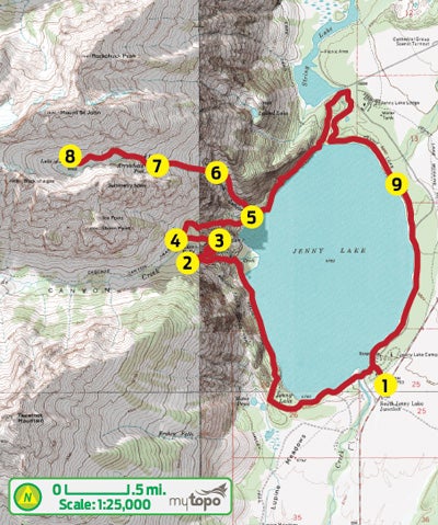
Come summer, the established trails near Jenny Lake can be hiker magnets. Your solution: This 12.4-mile circuit that tours several of the park’s must-see sights before ducking onto an unofficial trail that doesn’t appear on area maps. From the ranger station (1) near Jenny Lake Campground, pick up the well-maintained Valley Trail around the lake’s southern shoreline. After 2.5 miles, bear left at the fork for a gentle climb up the Cascade Creek drainage to Hidden Falls (2), which plummets 200 feet down tiers of boulders.

Next, cross a bridge over the creek and follow the switchbacks to Inspiration Point (3), a rocky pulpit overlooking the entire lake. From here, the trail curves west into Cascade Canyon for less than half a mile to a junction (4); turn right and descend to Jenny’s western shore. At mile 4.3, turn left on the Valley Trail and hike north for .1 mile.
Immediately after crossing a stream (mile 4.4) on a small bridge, watch closely for an unsigned turnoff (5) into Hanging Canyon; veer left here. Keep the stream on your left as you follow the obvious user path—soft with decomposing trees and crowded by ferns and towering stalks of purple monkshood—through lush terrain reminiscent of the Pacific Northwest.
ADVERTISEMENT
Soon after the route enters the canyon, the climbing ramps up (you’ll notch 2,800 feet in the next 1.5 miles) as the trail switchbacks up a forested hillside that’s slowly recovering from a wildfire nearly a decade ago. Pass Ribbon Cascade (6), where narrow bands of water plunge down tiered outcrops, and maneuver around intermittent stretches of thick deadfall caused by heavy snows in 2011. At mile 5.3, contour southwest across patches of slabby granite to reach Arrowhead Pool, the first of the canyon’s three lakes.
Drop down a spur to the shore (7), then continue another three-quarters of a mile on a path that runs along the north side of Ramshead Lake to Lake of the Crags (8), tucked into a pinched cirque of towering rock walls. (Tempted to stay longer? There’s one campsite per lake.) Descend back to the canyon’s mouth and turn left. The final 4.5 miles wrap around the north and east shores (9) of Jenny Lake to the ranger station.
GPS databackpacker.com/hikes/1636658