Updated December 3, 2024 08:51PM
Fall Hiking in the Bankhead National Forest, Alabama
The hardwood forests, scalped cliffs, and sandstone caves of northern Alabama are good any time of year, but they’re hard to beat with fall’s mild temperatures and electric foliage. It’s time to reap the rewards of the South’s best season.
'Steve Minor'
The insider
The Bankhead—which includes the Sipsey Wilderness—is Janice Barrett’s backyard. And as outreach coordinator for the advocacy nonprofit Wild South, she takes full advantage of it. Barrett leads hikes exploring the wilderness’s caves and ridges all year.
Canyon country
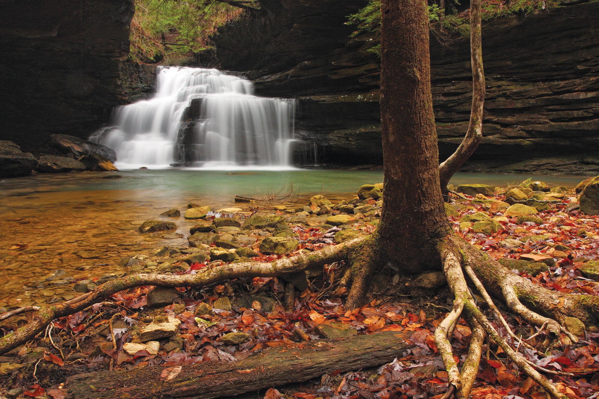
The swimming hole below 40-foot Caney Creek Falls is no secret. But most hikers stop at the falls 1 mile in—leaving the off-trail extension deeper into the canyon all for you. Continue downstream on the social trail along the South Fork of Caney Creek another .8 mile to reach a 20-foot cascade Barrett calls Lower Caney Creek Falls (there’s no official name). From here, the trail disappears and the sandstone walls deepen to 50 feet. Hike on and keep your eyes peeled for shallow overhangs; these rock shelters were used by prehistoric inhabitants 10,000 years ago. Turn back at the junction with the North Fork of Caney Creek for a 5.9-mile out-and-back.
Golden hour dayhike
Toward the end of October, you’ll find a fiery palette of fall colors on any trail in the Bankhead. But for a view that’s next-level idyllic, make like a photographer and chase the light: “The Rippey Trail runs north-south, and on a fall afternoon, when the sun is shining from the west, it’s a beautiful scene,” Barrett says. For a 7.5-mile out-and-back, follow Rippey Trail 201 along a ridge thick with northern red oak, hickory, sugar maple, and American beech. Then hang a left on Trail 206 to descend into the Sipsey Fork canyon, a short-but-steep drop with expansive views over the forest’s mosaic of reds, oranges, and yellows. Trace the river for a half mile, then head back on Trail 206 to link back to 201.
ADVERTISEMENT
Off-trail overnight
In the Sipsey’s little-tracked northern reaches, “you can drop down any canyon, follow a stream, and find beautiful places to camp,” Barrett says. Her top pick for those with navigation chops: the roughly 5-mile, partially off-trail loop linking the Lick Branch and Thompson Creek areas. From the Braziel trailhead, immediately head cross-country to the southwest and follow the unnamed creek. Pick your way down into the canyon, where ankle-deep Lick Branch flows between sandstone walls and limestone outcroppings. Scout an established campsite under the trees, then ditch your pack and explore the side canyons riddling the area—you might find unnamed waterfalls and more rock shelters. Next day, head west to Thompson Creek, then climb Warlick Ridge back east to hook up with the Gum Pond Trail back to the road and your car.
Multiday epic
Get a grand tour of the Sipsey on Barrett’s favorite trip: a four-day, 40-mile loop that meanders through each of the region’s ecosystems, from upland forests to sandstone canyons to fern-filled gullies. The logistics are a bit intense, but it’s worth it: You also get abundant seasonal waterfalls (November through May) and a firsthand look at the area’s human history, from post-Ice Age shelters to 19th-century whiskey stills. Follow Trail 203 from the Flannigan trailhead on the wilderness’s eastern edge down to Borden Creek, then link Trails 207, 208, and 210 to camp under the forest canopy near mile 9.5. Day two’s hike stays high on a ridge for almost 7 miles, connecting Trails 210 and 223. Day three, follow Trails 208 and 206 past Eye of the Needle (a tight boulder squeeze) and Ship Rock (a prominent, prow-shaped bluff) before taking Trail 209 east along the Sipsey Fork. To finish, link Trails 209, 200, and 203.
Birder’s campground
Avian enthusiasts pitch their tents at the quiet, 13-site Brushy Lake Campground for a peek at great blue herons, kingfishers, and, in spring and fall, migratory species such as orchard orioles, yellow-throated vireos, and warblers. Not among the binocular set? Launch a kayak or canoe from the campground and paddle the day away on 35-acre Brushy Lake or 10 miles along Class I and II Brushy Creek to Hickory Grove Road (portage around the dam on the southern shore).
ADVERTISEMENT
Trip planner
Season Year-round Permits None car camping $5/night (first-come, first-serve) Maps Bankhead National Forest
and Sipsey Wilderness by Carto-Craft Maps ($5 each)